|
|
Post by Michael John on Feb 17, 2008 18:24:48 GMT -5
Anyone familiar with rockhounding in Afton Canyon? I plan to go down there in the next week or so, but after doing a bit of reading on the internet, it appears that you have to "know where to go" there. I'll be going down there in my car (Chrysler Sebring), so decent dirt roads are okay, but "off-roading" is out of the question.
All good directions to definate hounding locations would be much appreciated!
If anyone would like to meet-up down there, that would be cool, too! My schedule is flexible.
|
|
mike4bears
spending too much on rocks

Member since December 2007
Posts: 275
|
Post by mike4bears on Feb 18, 2008 13:37:53 GMT -5
|
|
Sabre52
Cave Dweller  Me and my gal, Rosie
Member since August 2005
Posts: 20,456
|
Post by Sabre52 on Feb 18, 2008 17:08:18 GMT -5
Michaeljohn: I've been hunting the north Cadys for about 35 years. A lot of the good locations are in about 15 miles by tough four wheel drive road. You can with good luck find some fine materials in the outflow gravels of Afton Gorge which can be accessed off Basin Road off hwy 15 about 45 miles NE of Barstow. Simply drive south towards the RR tracks on Basin road toward the offroad vehicle area. A couple miles down the road you'll hit a fork where one branch ( the worst) goes straight south and the other better road turns towards the hills. Stay straight on the bad road till you hit the RR tracks. No good rocks on the other road. Park anywhere on the hwy 15 side of the tracks and hunt the gravel beds going into Afton canyon or drive the gravel road into the canyon making stops to check the gravel. Lots of fine moss, jasper, nodules, orbicular rhyolite etc. some of huge size. Only thing is the sand which can vary from trip to trip and the amount of gravel exposed which also varies. I've seen the road to the RR tracks impassable even to a four-by a few times and I've had to dig out once myself so be careful where you put your tires. The road into the real good stuff is marked by trail markers and takes off across the tracks to the south but stay out of there unless you've got several 4X4 cars in your group. Very easy to get stuck out there. You can see the roads on Google satellite photos if you want to get the lay of the land. Just put in Basin Road and follow the road on the maps. The photos are so good I can even spot the foot trails we take into the fluorite mine plume digs....Mel
|
|
AGATEGRRRL
spending too much on rocks
AGATEGRRRL
Member since October 2007
Posts: 466
|
Post by AGATEGRRRL on Feb 18, 2008 20:33:51 GMT -5
Michaeljohn - Mel is correct about the Basin road area - I know it well. It is extremely easy to get stuck in the sand there & you must be very careful if you plan to go there. It is never good to go there alone & you HAVE to have 4 wheel drive if you cross the RR tracks. There are many safer & easier places to access in that area near Barstow off of hwy 15 or hwy 40 - I would highly recommend doing that instead if you can.  Patti |
|
|
|
Post by Michael John on Feb 18, 2008 22:45:41 GMT -5
Wow, thanx! I was under the impression that the "loop" from Afton Canyon Road ... through the canyon ... and then up Basin Road was all a decent gravel road. Okay, just to clarify what you've said: In this pic, the green dots take me down to the canyon, but once I hit the blue dots I should start looking for good rocks? I can continue driving along the blue dots until I get to the red X? Rock collecting is on the mountain sides just north of the red X? 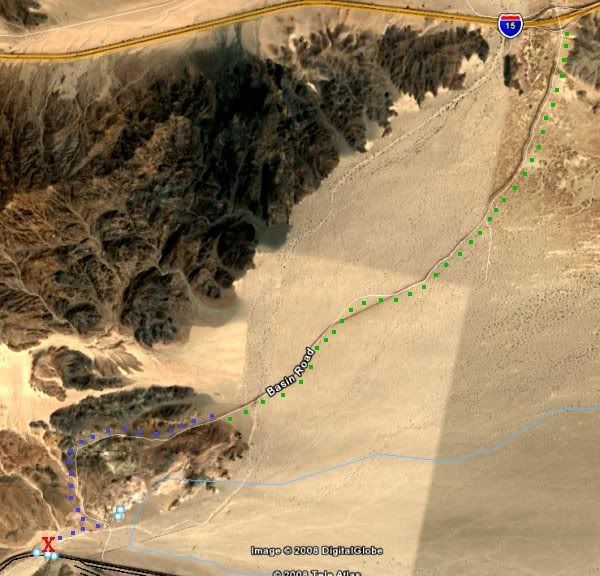 And this next pic is "The Canyon" ... I'm guessing it's about 3 miles from end to end. This area is sandy and my car won't make it through there? 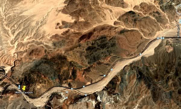 From a couple of stories I read, apparently most people go down Afton Canyon Road. Is this also a good way to go, or is the way you described better? See dots in the pic: 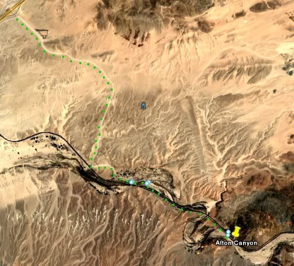 Last but not least, this next pic shows the area along I15 from Afton Canyon up to Halloran Springs. The Turquoise X at the top is famous Turquoise Mountain. Next to that, the yellow Xs are an historical area very rich in Copper, Silver, and Gold. The Green X is the famous Blue Bell mine (and a dozen other near-by mines which were massive gem producers). Now, I'm curious if anyone knows anything about the orange X areas (before I'd get to Basin Road), or the red X areas (just after Basin Road). I'm thinking that since they're in this good mineralization area, there's probably some good stuff in those areas. Can anyone enlighten me? 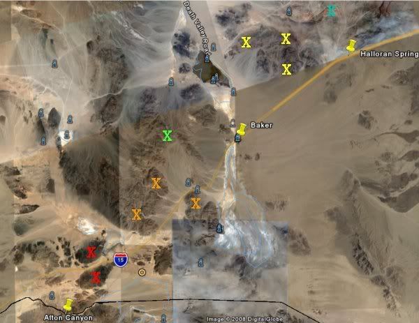 For this trip, I don't want to go further than Afton Road. There's plenty between Pahrump and Afton Canyon for me to explore in a day. LOL I figure if I can get 200-300 pounds of whatever, it'll be a good day. ;D |
|
Sabre52
Cave Dweller
Me and my gal, Rosie
Member since August 2005
Posts: 20,456
|
Post by Sabre52 on Feb 18, 2008 23:09:56 GMT -5
Michaeljohn: Nope, your dots took the wrong fork in the road. You have to go south ( left at fork) on the fainter road towards the Basin siding at the fork not turn into the hills on the new mine road. The right fork takes you out of the good rock territory and out to a private mine with no trespassing signs last I looked. The hills around that mine at the X suck for rocks. The good agate and jasper deposits originate in the hills to the south of the RR tracks if you want to do some serious and fairly dangerous hiking. Lots of box and hanging canyons and very easy to get badly lost south of the river if you don't know the area. You want to get to the gravel beds at the east end of the canyon. The left road at the fork takes you right to the RR crossing at the exit of the gorge. Also, last I drove it, the road through the gorge from the campground had several deep fords of the Mojave River ( over our truck mufflers and if you didn't check it first even deeper). Also lots of soft sand and some steep climbs. We actually gave up on it with our four bys even though we probably coulda made it through if we took our time. I'd say it's closer to 10 miles and a long slow ten miles too.The area around the campground off Afton road is, to my way of thinking pretty hunted out. Don't even expect to find huge quantities off Basin Road as it's near Zzxyx and often hunted. I always find a bucket or so full in a days hunt but I really know what to watch for. Some of the materials are hard to spot, especially the beautiful silicified rhyolite nodules. I wouldn't expect to really load up but the area is well worth hunting as there is some very high quality material in the lower canyon....Mel
PS: I just pulled up the Google photo of the mine road ( right fork) and it does show it going through to the RR crossing now. Haven't gone through that way so I don't know if that's still a private road or not. Most the hunting I do is between the mine and the east canyon mouth and on the gravel beds along the Mojave running parallel to the south fork of Basin Rd.Mel
|
|
|
|
Post by Michael John on Feb 19, 2008 3:06:38 GMT -5
Now ya did it! Ya went and got me confused! LOL Okay, first ... this is the way to go? 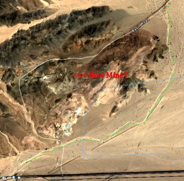 Now lemme try to break down what you said and go from there... "The good agate and jasper deposits originate in the hills to the south of the RR tracks if you want to do some serious and fairly dangerous hiking. Lots of box and hanging canyons and very easy to get badly lost south of the river if you don't know the area."If it's the area in the pic below, that's some nasty terrain ... about a 5 mile diameter circle of peaks and valleys. The smartest way to explore an area like that is to go up a wash, then turn around and go back the same way you came in. I wouldn't mind going up in there a bit if I had an idea of where I'd be most likely to find good stuff and where to start. I broke the area up into eight sectors ... maybe you could tell me which sector or two would be best, about how long a hike it would be, and what I'd be looking for? 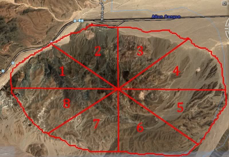 "You want to get to the gravel beds at the east end of the canyon" "You want to get to the gravel beds at the east end of the canyon"Where-abouts is that? Is it in one of the sectors on the map above? "I always find a bucket or so full in a days hunt but I really know what to watch for. Some of the materials are hard to spot, especially the beautiful silicified rhyolite nodules."I wouldn't know a "silicified rhyolite nodule" from a petrified mule's nut. I'm mostly interested in Jasper, and maybe some Agates if I happen across them. If I find other cool-looking stuff, it's all gravy. Would you happen to have any pics of Agates and Jasper found there, or any other stuff you've found there? I'm after a LOT more than a bucket full. If I have to make a bunch of hiking trips up into mountain washes to get it, that's fine with me. I don't want to sift through over-hounded "public" areas for little pieces of left-overs. That would be a complete waste of my time. Would a mountain bicycle do me any good out there, if nothing more than just to wheel my pack out, or are the washes too nasty for that? "Most the hunting I do is between the mine and the east canyon mouth and on the gravel beds along the Mojave running parallel to the south fork of Basin Rd."This area? 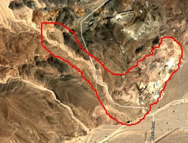 Did you ever call the mining company up and ask for permission to hound on their land? Most don't mind a little hounding as long as you don't go inside mines or specific dangerous areas. |
|
Sabre52
Cave Dweller
Me and my gal, Rosie
Member since August 2005
Posts: 20,456
|
Post by Sabre52 on Feb 19, 2008 23:42:41 GMT -5
MIchaeljohn; First, the area you've circled in your last pic is geologically not much good for quartz gems. I've never found much of anything there in the mine region.. On pic #1, your green dots are now correct. Hunt the main canyon gravel beds thoughout the canyon below your red circle which is the Mojave river gorge. On the last pic, the creekbed in your red area is just a wash. Mountain bike would do no good as the area is too soft for bike tires and much of it too rocky. Finally, your segmented circle is actually north of the main collecting area which would be a few miles to the SW of your marked area and rough country indeed accessible only by four wheel drive and never by yourself. Approx 15 miles of rough road in and some of the truck climbs are near vertical to get to the good stuff. Actually though, huge agate and jasper deposits abound south of the tracks and there's certainly good stuff in your segmented circle but I'm too friggin lazy and careful to venture into that country on foot. ( I actually did once a few years ago and found some nice moss agate but it was a hell of a hike and we had kids along and I wound up carrying lots of their tools and stuff back which sucked). I guess I'm fairly selective in my hunting because I never bring out the quantities you're wanting. I'm only a hobby rockhound, not a commercial collector and this is all BLM land which limits your take to about a packfull a day per person. Maybe someone else can put you on to the mother lode but in the areas I hunt, I usually only bring out a couple of milk crates for a multi day trip. I'll try to take a few pics in the next day or so and post them here so you can see what to look for....Mel
|
|
|
|
Post by Michael John on Feb 20, 2008 3:24:56 GMT -5
huge agate and jasper deposits abound south of the tracks and there's certainly good stuff in your segmented circle but I'm too friggin lazy and careful to venture into that country on foot.
Since I'll be driving my car down there, I'll be limited to collecting areas I can reach either by car or on foot. So, since I'll have to park my car where my green dots meet the railroad tracks, I'll be on foot to do the collecting, which isn't a problem. I don't mind hiking 20 miles in a day and I'm not in the least bit intimidated by mountainous terrain. However, knowing exactly where to go would save me WASTED walking.
Where do you mean by "south of the tracks" in the above statement? I had thought you meant the circled mountain area.
You said there is good stuff in the segmented area. Which segments have you been in and what's there? Jasper and Agate?
In a previous post you mentioned "the gravel beds" at the east end of the canyon. Where are they, specifically?
The BLM rarely monitors rockhounds' activities. Their only beef would be with guys filling the back of pickup trucks. Not that I would ever do that!
|
|
Sabre52
Cave Dweller
Me and my gal, Rosie
Member since August 2005
Posts: 20,456
|
Post by Sabre52 on Feb 20, 2008 10:49:14 GMT -5
You know, we're talking an area here much larger than what your maps show ( probably close to 15 X 40 miles) and you might even have problems reaching the railroad tracks in a regular car. The gravel beds I'm talking about run the length of the gorge along your green dots you've shown on your map. They're intermittent and huge and dispersed throughout the canyon. In actuality, the places I've hiked from the canyon directly in the mountains to the south of the tracks are closer to the campground and west of your map and you can't reach the takeoff point in a car because it takes fording the river several times. The other areas where I go south of the tracks are again off your maps and way in by 4-by plus you'd need a guide because everything is in certain areas and difficult to find. Sorry, but It's impossible to explain how to get there in a note. The only area actually "possibly" reachable by a car and the casual collector are the gravel beds.....Mel
|
|
rallyrocks
fully equipped rock polisher

Member since November 2005
Posts: 1,507
|
Post by rallyrocks on Feb 20, 2008 10:56:26 GMT -5
Regarding BLM enforcement...
While we were lounging around the campground on the Burro Creek trip, Len the local BLM guy stopped in and reminded us of the limits, and that we were only to be hobby collectors taking less than 25 lb/day or 250 lb per year for personal use, Jamie jumped in and read him some of the rules from memory which seemed enough to let him know we were OK...
- despite -ahem- "someone's" trailer with probably a good quarter ton of boulders parked at our campsite...
Probably not a good idea to push it like that, but I think they'd be more concerned with someone taking bigger truckloads out, a hundred pounds or so in a pickup shouldn't get you in any trouble.
Filling the bed of a one-ton, well- that might raise some eyebrows....
|
|
|
|
Post by johnjsgems on Feb 20, 2008 11:19:55 GMT -5
If you are interested in marble there is a huge deposit and easily reached by car. Exit at Afton Canyon Rd. Go West on the road North of the freeway and along the freeway. It veers 90 degrees at the end. Follow that road and look to the right for a big green outcropping/quarry site. A landscape rock company quarried the green marble but found it too hard for what they wanted. Colors are from dark to light and takes a nice polish.
I've seen "Chinese Writing Rock" from ZZzx Rd. (several miles North of freeway) but have not gone out to locate it. Supposed o be boulders along the road. Has smaller pattern than the Auburn stuff.
|
|
Sabre52
Cave Dweller
Me and my gal, Rosie
Member since August 2005
Posts: 20,456
|
Post by Sabre52 on Feb 20, 2008 14:11:32 GMT -5
Michaeljohn: Posted some Cady agate pics for you in the photo section. Those all came off the gravel beds we've been discussing.....mel
|
|
|
|
Post by Michael John on Feb 20, 2008 15:07:50 GMT -5
Rallyrocks, for that trip I'll be in a Chrysler Sebring, collecting on foot with a pack. and I'll be alone. Chances of arousing the interest of a ranger will be a million to one. Besides, from what I'm understanding so far, it looks like the probability of collecting more than 100 pounds in a day will be slim to none.
In Arizona, they may have that weight limitation, but not in California, according to the Barstow office BLM sight. There, it says "whatever you can fit in a day pack". My pack will EASILY hold 100+ pounds of rock.
John, those locations seem like they'd be easy to find. I'll definately check them out while I'm "in the area". Thanks!
Mel, now I understand that "the gravel beds" are throughout the area, not just one spot. Are these "gravel beds" the spill-out at the end of the washes between the mountains? Are the bright red/yellow Jaspers easily spotted when looking through the "gravel bed" areas? Thanks for the beautiful pics! I'd be more than happy with a bunch of that!
I'm going to call the Barstow BLM office to inquire about car accessibility. I need to know, for sure, if I can go all the way down Basin Road to the railroad tracks. If not, maybe I can get a BLM guy to take me out there ROTFLMAO.
|
|
rallyrocks
fully equipped rock polisher
Member since November 2005
Posts: 1,507
|
Post by rallyrocks on Feb 20, 2008 16:56:04 GMT -5
The other thing about roads out there in the desert, which I'm sure you know all too well, what might be passable in a Sebring one weekend could be totally impassable a few days later.
All this discussion has me psyched to make another weekend road trip down there myself!
|
|
Sabre52
Cave Dweller
Me and my gal, Rosie
Member since August 2005
Posts: 20,456
|
Post by Sabre52 on Feb 20, 2008 18:15:08 GMT -5
Michaeljohn: First off, Rally is correct. Road conditions change with every wind storm. I've seen the road impassible 1/2 mile from the freeway and other times drivable by any car at all. The fords are another story as the river flows a lot now and the crossings can be deep and sandy. The agate etc is bright colored and easy to spot with the sun behind you. The rhyolite is tough as it just looks like a knobby red rock. My only gripe about the canyon is you lose sun early in the day as it drops behind the high hills and it's slow coming up in the morning to the point where you can hunt, especially in the winter. Also colder than hell sometimes at night in the winter and often very windy...Mel
|
|
|
|
Post by johnjsgems on Feb 20, 2008 22:14:25 GMT -5
If anyone goes be sure to post. That area is close to home (if we happen to be home). There are a lot of good spots on the South side and Hector Rd. areas as well.
|
|
Bucknutty
starting to spend too much on rocks
Member since November 2017
Posts: 171 
|
Post by Bucknutty on Jun 12, 2018 0:53:20 GMT -5
If you are interested in marble there is a huge deposit and easily reached by car. Exit at Afton Canyon Rd. Go West on the road North of the freeway and along the freeway. It veers 90 degrees at the end. Follow that road and look to the right for a big green outcropping/quarry site. A landscape rock company quarried the green marble but found it too hard for what they wanted. Colors are from dark to light and takes a nice polish. I've seen "Chinese Writing Rock" from ZZzx Rd. (several miles North of freeway) but have not gone out to locate it. Supposed o be boulders along the road. Has smaller pattern than the Auburn stuff. Is the marble all hard rock work or is there some loose stuff? I'm planning a trip out that way and love marble. Just want to know if it's a short side trip or a good day's work. Appreciate your help. |
|
NRG
fully equipped rock polisher
Member since February 2018
Posts: 1,630
|
Post by NRG on Jun 27, 2018 8:47:27 GMT -5
If you are interested in marble there is a huge deposit and easily reached by car. Exit at Afton Canyon Rd. Go West on the road North of the freeway and along the freeway. It veers 90 degrees at the end. Follow that road and look to the right for a big green outcropping/quarry site. A landscape rock company quarried the green marble but found it too hard for what they wanted. Colors are from dark to light and takes a nice polish. I've seen "Chinese Writing Rock" from ZZzx Rd. (several miles North of freeway) but have not gone out to locate it. Supposed o be boulders along the road. Has smaller pattern than the Auburn stuff. Is the marble all hard rock work or is there some loose stuff? I'm planning a trip out that way and love marble. Just want to know if it's a short side trip or a good day's work. Appreciate your help. Its not marble, its andesite. Fill a pickup truck with any size hunk you want. Nobody will know its gone. Soft, takes a decent polish. Take the exit with the dead convenience store. The one west of basin road. I forget the name. Follow the paved road west until it swings north onto a dirt road. Follow that past the first green quarry and dry lake bed, if you can. Then go another mile or less to the second green quarry. That is where the the good stuff is. Patterns and color changes. I'm planning to go get some big yard boulders there. Wanna help? PS Hit the first quarry on the way out and explore there too! |
|
Bucknutty
starting to spend too much on rocks
Member since November 2017
Posts: 171
|
Post by Bucknutty on Jun 27, 2018 11:10:00 GMT -5
Is the marble all hard rock work or is there some loose stuff? I'm planning a trip out that way and love marble. Just want to know if it's a short side trip or a good day's work. Appreciate your help. Its not marble, its andesite. Fill a pickup truck with any size hunk you want. Nobody will know its gone. Soft, takes a decent polish. Take the exit with the dead convenience store. The one west of basin road. I forget the name. Follow the paved road west until it swings north onto a dirt road. Follow that past the first green quarry and dry lake bed, if you can. Then go another mile or less to the second green quarry. That is where the the good stuff is. Patterns and color changes. I'm planning to go get some big yard boulders there. Wanna help? PS Hit the first quarry on the way out and explore there too! I'd love to, but I'm in Phoenix. Was just out there last week, but it'll be a while before I have time to head that direction again. Thanks for the info! |
|


