|
|
Post by petrifiedwoodfarm on Oct 26, 2014 23:53:46 GMT -5
|
|
Fossilman
Cave Dweller 
Member since January 2009
Posts: 20,676 
|
Post by Fossilman on Oct 27, 2014 6:33:26 GMT -5
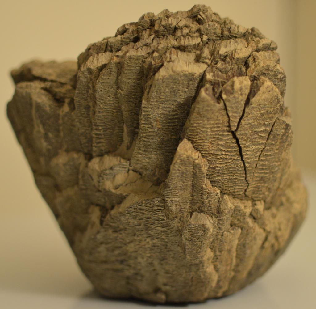
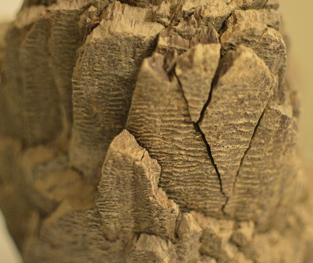
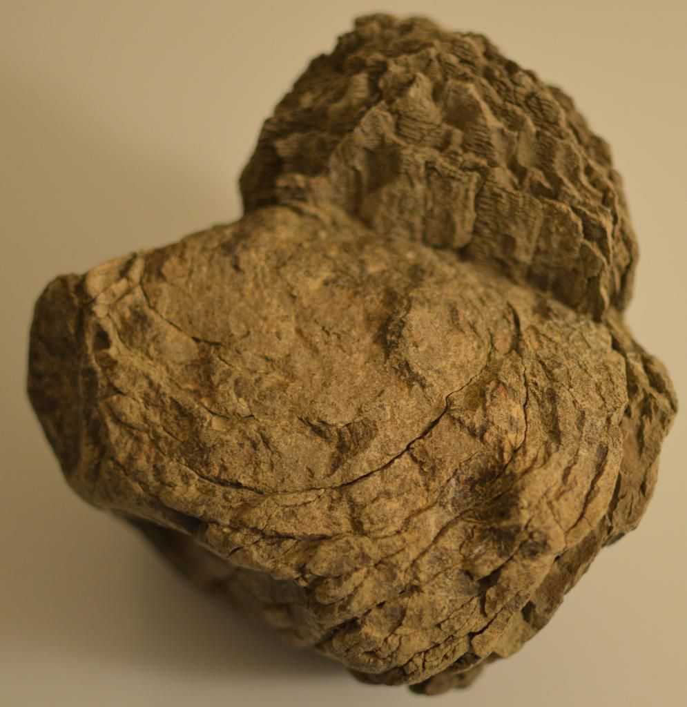
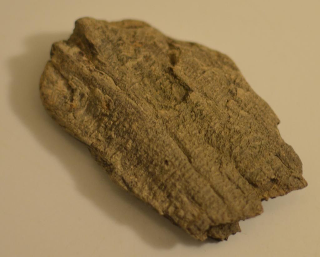
Michael,These pieces have me stumped!!! I love fossils.....To me,it looks like an undeveloped piece of petwood...
My opinion.........Hope some can ID this..
|
|
|
|
Post by snowmom on Oct 27, 2014 6:47:59 GMT -5
how very interesting. Do you find other identifiable fossils in that area also? (for example, most of the fossils we find here are Devonian era since we stand on a great reef of limestone which developed then) If you knew the age of the outcrop on the cliff it might
help narrow down the search by a few million years one way or the other.
|
|
|
|
Post by snowmom on Oct 27, 2014 6:49:40 GMT -5
|
|
|
|
Post by snowmom on Oct 27, 2014 6:53:37 GMT -5
|
|
|
|
Post by petrifiedwoodfarm on Oct 27, 2014 8:51:49 GMT -5
Thanks for taking your time reviewing the images (I do have many more from other angles, which I have not uploaded to PhotoBucket).
In my opinion, it looks like a reed or fern type of plant. That 3" circle in the centre seems where everything originates from, and develops to maturity as it makes it way to the outer rings of the plant.
The "fragment" is a fragment of one of what could have been an outer leaf of the plant.
Snowmom, you have come up with some very nice questions indeed. I shall do my best to answer your Q's the best I can.
1) We have found other marine fossils and petwood in the area. The "area" (area being Lake Diefenbaker and surrounding areas) is also known to be the home of dinosaurs. In the area where the said specimen was found, I have also located a fragment of a rib bone, which is opalized with Mother of Pearl (of which I had intended to share an image of in the future, here). Within the next few days, I shall take photos of the other interesting finds to share with all.
2) The cliff that erodes away seems to me to be nothing more than Glacial Till. In the coming weeks I shall take pictures of various cliff sides (sorry, but it is hunting season around here and we could easily be mistaken for a Goose or Duck (of which there are millions here right now), or a Deer, Elk, Moose or other game (Coyote or Wolf). I'll see if I have a few landscape images in my library to share, just to give all an idea of what we experience.
3) Wow! Thanks for the image of Lake Agassiz! Lake Diefenbaker is the western most portion arm of the lake, on the South Saskatchewan River. The River was Dammed to create one of the largest man-made lakes in the world. This year, the river levels are the highest I have ever seen, making access to 95% of our day trips along the shoreline impossible. Of course, Lake Diefenbaker is a large area of land, and it has limited access to the water, since it is mainly Rural Farmland, where the Farms are Mega-Farms and own many sections of land like a large quilt. Though Saskatchewan has the greatest road surface of ANY State or Province (yes, that includes California too), the road surface was created for the farmers, in order to get their grain to market. Unfortunately, access to the lake area was not on the minds of the "Grid Road Master Mind". South of Saskatoon, the majority of the roads are every 2 x 1 miles (every 2 Mi east-west and 1 Mi north-south). The problem for us, they are the WORST Road Surface on the planet!!! 85% are of Gravel 5% Sand-Tar mix (heaves all the time), and 10% dirt roads. You take your chances on our roads. This is mainly because Saskatchewan was of course at the bottom of the seabed. There is NO SOLID rock at all around here. Everything heaves! Even the Trans-Canada Highway! About 5 years ago, there was a major break in the Trans-Canada in Maple, Sask. This was due to Spring break-up and the melting ice just washed the sands away from under the highway and tore out a section larger than a football field!
4) As for this final image, my mind had something radically different than this image shares, but since I am not a master of the Geologic or Flora past, who knows... I will work through the website you shared and see if I can come up with something else. snowmom, you just might be on to something here, though!
I plan to send images of my find to the Royal Saskatchewan Museum to see if the Pro's can shed some light on the situation. First I have to find an email address to ensure it is directed to the correct department for identification.
Michael
|
|
|
|
Post by petrifiedwoodfarm on Oct 27, 2014 9:16:06 GMT -5
As a footnote to the above,
We have also located some beautiful Agates (an extremely rare find!), a few rocks that look like Jade! (Now, I ask myself how does a Jade-like product make its way to the Lucky Lake - Beechy area??? - Outside of Glacial Erratic Till, I'm totally stumped).
With my present employment as Farm Fuel Delivery Agent for the Co-Op, I have the wonderful ability to access a huge swaths of land, keeping a keen eye open for new areas to explore and animals to see. I also have some good maps of the district which aides me on the job as well as during my explorations. GPS, Google Earth are other aides as well.
There are land features here that boggle the mind! I have lived in the area for nearly 5 years on, and this past month was the first time we have encountered the local "Sandcastles"! This is a natural erosion of the sandy seabed, but are about 150' in the air and about 300' long!
You can clearly see the Bear Paw formation, while standing on the Sandcastles, where dinosaurs are known to exist in Montana! I was floored to understand that that formation in Havre, MT has something to do with Beechy, Saskatchewan! The Badlands are truly Bad-Ass indeed!
This just may have been fun and enjoyable ramblings, but one hopes not to be the case...
Michael
|
|
spiritstone
Cave Dweller
Member since August 2014
Posts: 2,061
|
Post by spiritstone on Oct 27, 2014 10:55:30 GMT -5
As a footnote to the above, We have also located some beautiful Agates (an extremely rare find!), a few rocks that look like Jade! (Now, I ask myself how does a Jade-like product make its way to the Lucky Lake - Beechy area??? - Outside of Glacial Erratic Till, I'm totally stumped). With my present employment as Farm Fuel Delivery Agent for the Co-Op, I have the wonderful ability to access a huge swaths of land, keeping a keen eye open for new areas to explore and animals to see. I also have some good maps of the district which aides me on the job as well as during my explorations. GPS, Google Earth are other aides as well. There are land features here that boggle the mind! I have lived in the area for nearly 5 years on, and this past month was the first time we have encountered the local "Sandcastles"! This is a natural erosion of the sandy seabed, but are about 150' in the air and about 300' long! You can clearly see the Bear Paw formation, while standing on the Sandcastles, where dinosaurs are known to exist in Montana! I was floored to understand that that formation in Havre, MT has something to do with Beechy, Saskatchewan! The Badlands are truly Bad-Ass indeed! This just may have been fun and enjoyable ramblings, but one hopes not to be the case... Michael It sounds to me your in southern Sask. There is a few impact craters to the south and west of you that have tossed a lot of material around these parts. One place i particular like to go looking is in the Hands Hills area southern Alta. Chalcedony, angelwings, jaspers, agates etc... can be found scattered on the ground on the badlands. |
|
|
|
Post by petrifiedwoodfarm on Oct 27, 2014 21:38:10 GMT -5
Spirtstone, thanks for your tips! Lucky Lake is located on the western side of Lake Diefenbaker (well by 15kms as the crow flys). At the HWY 42 & 45 Junction. Due east of Calgary.
Is that you narrating the video? It seems to be a very windy day, and since the camera is pointed into the wind, the wind overpowers the author. I know there is some important information he is trying to share, but I am unable to pick out the key points. Spiritstone, could you or were you able to pick out what the author is saying in the video? These Angelwings, what are they? Obviously a nice crystal, but do they grow flat, or is it a conglomerate and they break off from a larger source? Anyways, it looks like a nice find, and something worth investigating further on a lazy hot afternoon! Count me in next year. Oh, do you have rough co-ords for the Hands Hills area (or what direction from Settler)? Thanks for sharing with us.
P.S. I never knew there was an impact near the area! I have traveled the area many times while working the patch! Is this within the posted restricted zones? I never understood what those darn signs were all about, other than those darn signs = Dinosaurs near by! (that's all the intelligent information that was shared my way). Well since the wife loves camping in Drumheller and area, looks like a wonderful way to spend a week in the brush!
|
|
jerrys
spending too much on rocks

Member since February 2014
Posts: 263
|
Post by jerrys on Oct 28, 2014 21:30:55 GMT -5
this could be cone in cone
|
|
|
|
Post by Peruano on Oct 29, 2014 7:20:14 GMT -5
Michael, The specimens are interesting and unique, but hardly the kind of stuff that folks in the amateur world come across or are able to work in lapidary or mineralogical collections. Contacting the museum you mentioned will be one of your best bets. If you can find an appropriate person (expert) (capable and willing), they will probably want to see the photos to judge relevance and fragility of shipping. Museums flourish on data - exact locality information - geographic description is nice, but gps coordinates are invaluable in case someone needs to go back to look at the site for substrate info, further exploration etc. Sounds like you may need a gps anyway to keep track of your widespread travels. Interesting. Possibilities could potentially span terrestrial plants to marine sponge, algae, or ?? Finding an expert may be difficult unless the specimen is something that has been well studied, but you may get lucky. Tom
|
|
free4rms
freely admits to licking rocks
 My little pet walrus
Member since January 2007
Posts: 839
|
Post by free4rms on Oct 29, 2014 7:44:46 GMT -5
I have an idea what this fossil is, but I am not 100% sure. The instant I saw the photos, the I.D. popped into my head. I think this is a chunk of a mammoth molar. I find the from time to time here in S.C., and the pattern of horizontal, squiggly lines on the outward facing surfaces of the fossil look just like what you find on mammoth tooth enamel. In addition, at the broken surface of the "top" of the fossil, you will see somewhat parallel, zig-zag patterns of enamel that are about a little less than a quarter of an inch thick. Mammoth teeth are made up of parallel "plates" of enamel, separated by dentine, and each plate is about 1/8 to 3/4 inch thick. The plates or layers you see in the photo showing the internal pattern are a more closely packed together and not separated by the dentine layers like you would expect to see, but this may be because you are looking at the base of the tooth nearest the root area. Here is a link to a photo showing a mammoth tooth that displays the characteristics I described:http://www.thefossilforum.com/index.php?/topic/21136-mammoth-tooth-fragment/
Now, I may be totally wrong on this identification. Keep in mind that this would most likely have come from a Pleistocene exposure. Let's just say that if I found this in a S.C. fossil bed, mammoth would be my first guess. Google "mammoth tooth fragments" and you might come up with some photos that would help you decide if this is the culprit.
|
|
|
|
Post by petrifiedwoodfarm on Oct 29, 2014 11:15:41 GMT -5
Michael, The specimens are interesting and unique, but hardly the kind of stuff that folks in the amateur world come across or are able to work in lapidary or mineralogical collections. Contacting the museum you mentioned will be one of your best bets. If you can find an appropriate person (expert) (capable and willing), they will probably want to see the photos to judge relevance and fragility of shipping. Museums flourish on data - exact locality information - geographic description is nice, but gps coordinates are invaluable in case someone needs to go back to look at the site for substrate info, further exploration etc. Sounds like you may need a gps anyway to keep track of your widespread travels. Interesting. Possibilities could potentially span terrestrial plants to marine sponge, algae, or ?? Finding an expert may be difficult unless the specimen is something that has been well studied, but you may get lucky. Tom Thanks Peruano for this info! Yes, I always travel with my Garmin T450 Oregon! GPS coords are always noted when in the field. As for fragility, yes, it sure is fragile! I would not ship it, but rather travel in person. I've seen too many YouTube's of UPS, Fed Ex, etc guys just tossing items around! Also, we have located individual fragments over a large area, in multiple locations. I know the U of Sask frequents the lake, though farther southwest from where we have been able to gain access this year. The water levels are just way too high, and unless you have a boat or are a fish, pickings are real slim this year in the lake! We just hope for a dry winter this year. Fingers crossed. Thanks Tom! |
|
spiritstone
Cave Dweller
Member since August 2014
Posts: 2,061
|
Post by spiritstone on Oct 29, 2014 11:41:03 GMT -5
Spirtstone, thanks for your tips! Lucky Lake is located on the western side of Lake Diefenbaker (well by 15kms as the crow flys). At the HWY 42 & 45 Junction. Due east of Calgary. Is that you narrating the video? It seems to be a very windy day, and since the camera is pointed into the wind, the wind overpowers the author. I know there is some important information he is trying to share, but I am unable to pick out the key points. Spiritstone, could you or were you able to pick out what the author is saying in the video? These Angelwings, what are they? Obviously a nice crystal, but do they grow flat, or is it a conglomerate and they break off from a larger source? Anyways, it looks like a nice find, and something worth investigating further on a lazy hot afternoon! Count me in next year. Oh, do you have rough co-ords for the Hands Hills area (or what direction from Settler)? Thanks for sharing with us. P.S. I never knew there was an impact near the area! I have traveled the area many times while working the patch! Is this within the posted restricted zones? I never understood what those darn signs were all about, other than those darn signs = Dinosaurs near by! (that's all the intelligent information that was shared my way). Well since the wife loves camping in Drumheller and area, looks like a wonderful way to spend a week in the brush! No not me, at least he could of held the camera the proper way ,LoL. I think he mentions that a lot of it is Glacier deposit that was dropped so chances are you wont be able to dig out a pocket. Angel wings are chalcedony. From Stettler it is south. I hope the link works. travelingluck.com/North+America/Canada/Alberta/_5970091_Hand+Hills.htmlThe Bow city crater is a close impact site and there is a large one in Montanna close to the border. Name just isnt ringing a bell at the moment. en.wikipedia.org/wiki/List_of_impact_craters_in_North_Americaforgottenalberta.com/tag/amethyst/Not a problem, CC you on there next planned digs for spring and summer.  Good luck on the ID of your find. |
|
|
|
Post by petrifiedwoodfarm on Oct 29, 2014 11:44:59 GMT -5
I have an idea what this fossil is, but I am not 100% sure. The instant I saw the photos, the I.D. popped into my head. I think this is a chunk of a mammoth molar. I find the from time to time here in S.C., and the pattern of horizontal, squiggly lines on the outward facing surfaces of the fossil look just like what you find on mammoth tooth enamel. In addition, at the broken surface of the "top" of the fossil, you will see somewhat parallel, zig-zag patterns of enamel that are about a little less than a quarter of an inch thick. Mammoth teeth are made up of parallel "plates" of enamel, separated by dentine, and each plate is about 1/8 to 3/4 inch thick. The plates or layers you see in the photo showing the internal pattern are a more closely packed together and not separated by the dentine layers like you would expect to see, but this may be because you are looking at the base of the tooth nearest the root area. Here is a link to a photo showing a mammoth tooth that displays the characteristics I described:http://www.thefossilforum.com/index.php?/topic/21136-mammoth-tooth-fragment/ Now, I may be totally wrong on this identification. Keep in mind that this would most likely have come from a Pleistocene exposure. Let's just say that if I found this in a S.C. fossil bed, mammoth would be my first guess. Google "mammoth tooth fragments" and you might come up with some photos that would help you decide if this is the culprit. Free4rms, this is a lead which is NOT TOO FAR FETCHED!!! Not too far from us a few years back, a Mammoth was unearthed just outside of Kyle, Saskatchewan. The RM Road Crew was out re-working a grid road, and the grader operator kicked up some bones. Worked stopped, the UofS was called in, and the area was dug up, and now Kyle has a concrete statue of a Mammoth, and they now have a section in the local Museum of the find. I do believe the Original Mammoth resides either with the UofR (Regina) or the Royal Museum of Natural History, also located in Regina. One point that was note made public was the specimen was recovered from within the water, and not from a nearby cliff side. The lake water's wave action may have added to the separation from the core, this is if it is a Mammoth's Molar. The photos I took may be of a tooth inverted! Looks like we'll be making a trip into Regina this wintertime. I'll send emails to the University's and Museums. I'm most certain that there will be interest. Michael |
|
jerrys
spending too much on rocks
Member since February 2014
Posts: 263
|
Post by jerrys on Oct 29, 2014 12:56:32 GMT -5
|
|
jamesp
Cave Dweller
Member since October 2012
Posts: 36,154
|
Post by jamesp on Oct 29, 2014 15:41:44 GMT -5
It's not a mammoth tooth. Looks like a plant structure, as mentioned. Perhaps the basal portion. Please post findings.
|
|
Deleted
Deleted Member
Member since January 1970
Posts: 0
|
Post by Deleted on Oct 29, 2014 17:40:08 GMT -5
|
|
|
|
Post by snowmom on Nov 4, 2014 5:42:15 GMT -5
|
|
|
|
Post by pghram on Nov 9, 2014 15:40:56 GMT -5
I can't help w/ an id, but very nice specimens.
Rich
|
|