Banjocreek
fully equipped rock polisher
  
Member since March 2003
Posts: 1,115
|
Post by Banjocreek on Feb 16, 2004 8:58:18 GMT -5
I found this old mine on a topo map a few miles from me and went to see what they were doing.
It is abandoned, and it looks like they were digging gold, or silver when it was active. The interesting part is that the tailings had gone through a crusher and the residue was about 1 to 1.5 inches. Pawing around in that, I found a half a bucket of quartz, all perfect tumbler size and that is just the surface of maybe a couple of hundred tons of crushed tailings.
Some has interesting color, most of it is white.
Just thought it might be worth looking into; if you have any topo maps just look for the little crossed pick-ax icons and go see what they were digging for.
It is probably at least worth checking out the area. Of course this is Arizona, and a lot of abandoned mines can be found. I just thought that the tailings were an interesting place to start.
|
|
|
|
Post by rockyraccoon on Feb 16, 2004 21:48:15 GMT -5
2 questions: what are "tailings" and what is a topo map?
kim
|
|
Banjocreek
fully equipped rock polisher
  
Member since March 2003
Posts: 1,115
|
Post by Banjocreek on Feb 17, 2004 0:19:11 GMT -5
Mine tailings is all the left-over material once they get the rock broken down to harvest the, gold, silver, copper, whatever.
They have to dump that leftover material somewhere. The thing is that the tailings have some stuff in them that you and I might like, but that they have no interest in. In this case the tailings ranged in size from 1 inch to 6 inches in size of waste material type rock. Some mines out here dump all their tailings at the entrance to the drive to the mine, for people like us to pick over. "Easy pick'ins". A topo map is a topographical map showing land levels. (Kinda like the way a weather map draws the temperature readings across the country) You've probably seen them and you can get them for any area in the USA from a state government office of land management. They will have little makers were there once were mines. The icon typically looks like two crossed pick axes.
|
|
|
|
Post by rockyraccoon on Feb 18, 2004 9:11:13 GMT -5
having mines tails and different land levels?!?!  that's like being a kid and having willie wonka's factory down the street. thanks for the info. our land levels here are flat, flatter, and flattest  . kim |
|
Banjocreek
fully equipped rock polisher
  
Member since March 2003
Posts: 1,115
|
Post by Banjocreek on Feb 19, 2004 12:06:15 GMT -5
I don't mind sending out stone to you to beat up. Get me your address Kim, and I can box some up. I'm not charging for anything I send so no one can complain  I try to get out at least every other weekend, but never know exactly what I'll find. So it's a gamble. -Banjo |
|
MichiganRocks
starting to spend too much on rocks
  "I wasn't born to follow."
Member since April 2007
Posts: 154
|
Post by MichiganRocks on Mar 20, 2004 11:37:27 GMT -5
A little something about the topo maps. The site below allows you to download and/or print free topo and aerial maps of anywhere in the US. Topo maps go down to 2m resoulution and the aerial maps go down to 1m resolution. Topos not only show old mines, but they show old gravel pits as well. Hope this works better than the hpphoto idea.  terraserver.homeadvisor.msn.com/default.aspx terraserver.homeadvisor.msn.com/default.aspx |
|
|
|
Post by creativeminded on Apr 21, 2004 10:53:37 GMT -5
That is a really cool site, I was able to find the town that I live in. I imagine if I had played around with it a little more I would have found the house I live in.
Tami
|
|
James
freely admits to licking rocks
  
Member since October 2003
Posts: 876
|
Post by James on May 17, 2004 3:07:01 GMT -5
I know of a place that has a bunch of snow white quartz here in the goldrush country of california. It should polish up nicely. The location has huge boulders weighting tons! The hard part is breaking them up.
|
|
texmom
spending too much on rocks
  When life gives you lemons, squeeze it on fried catfish!
Member since February 2005
Posts: 344
|
Post by texmom on Apr 3, 2005 14:22:53 GMT -5
Is there anything interesting to be found at a clay pit? Marshall Pottery has been digging clay for many decades to make pottery. They do white and terra cotta. Just wondered if anything interesting might be found there.
I figure it is just sedimentary stuff, like most of East Texas, but thought I would ask
|
|
|
|
Post by gaetzchamp on Apr 14, 2005 15:47:23 GMT -5
Here's another excellent topo map site. I use it all the time www.topozone.comgaetz |
|
texmom
spending too much on rocks
  When life gives you lemons, squeeze it on fried catfish!
Member since February 2005
Posts: 344
|
Post by texmom on Apr 14, 2005 21:14:52 GMT -5
I think I'll move to Banjocreek.... or maybe in the next county to mandelinbrook  I love the name banjocreek, but too much fun not to think of another... now that I think of it... I like it. Course in Texas it would be pronounced Banjocrik |
|
smadelinker
starting to shine!

Member since October 2005
Posts: 47
|
Post by smadelinker on Jan 4, 2006 22:26:52 GMT -5
Speaking of tailings, I found a site that lists old mines which, if you know local history/geography, could help you find some tailings: mindat.org Happy hunting  smadelinker |
|
greenmann
spending too much on rocks
 
Member since August 2005
Posts: 325
|
Post by greenmann on Jan 5, 2006 17:40:45 GMT -5
Um, you might want to double check somehow after you find an old mine that no one else has a claim on it. Lots of the old mines in the Cascades now have people with new claims on them who are specifically looking for most of the same kinds of stuff we do- quartz chrystals, pyrite, etc. If you start going through these tailings and get caught, the fines are pretty steep for trespassing.
|
|
thehawke
freely admits to licking rocks
   My Lord and Master
Member since January 2006
Posts: 866
|
Post by thehawke on Jan 11, 2006 1:23:23 GMT -5
ooh there is an abandoned copper mine pretty close to us. I was thinking of heading out there sometime for some geocaching. But with mudslides currently flattening our state and floods everywhere, the kayaking will have to wait.
|
|
gemmaster
spending too much on rocks
 
Member since July 2005
Posts: 281
|
Post by gemmaster on Feb 8, 2006 20:52:00 GMT -5
kim,if you would please send me a list of the african rough rock you import i am a dealer myself would be glad to have you as a supplierfor any number of good reasons . the generosity of your sending the african autumn jasper blew me away, i hope you liked what i sent you if we can trade fine if not i will buy from you . i saw pics you posted some months ago of the rainbow jasper, the socalled and missnamed african blood stone , the silicated sodalite etc, drool profundo. your could easily become a heroine to my effots here in jawjah. thanks your friend . gemmaster
|
|
spacemanspliff
starting to spend too much on rocks
 
Member since January 2006
Posts: 171
|
Post by spacemanspliff on Feb 9, 2006 2:55:02 GMT -5
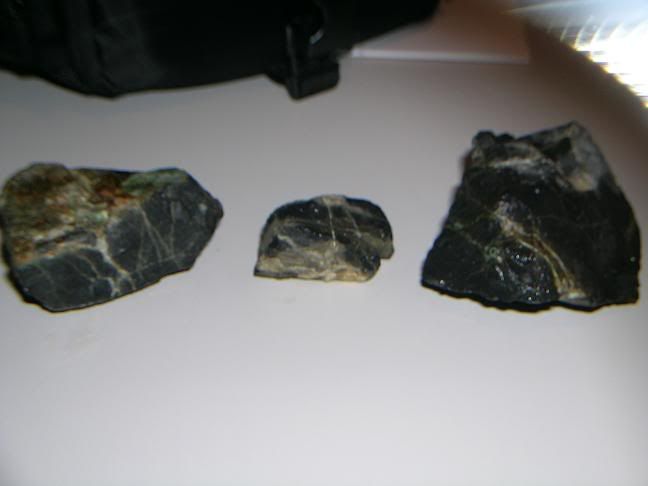
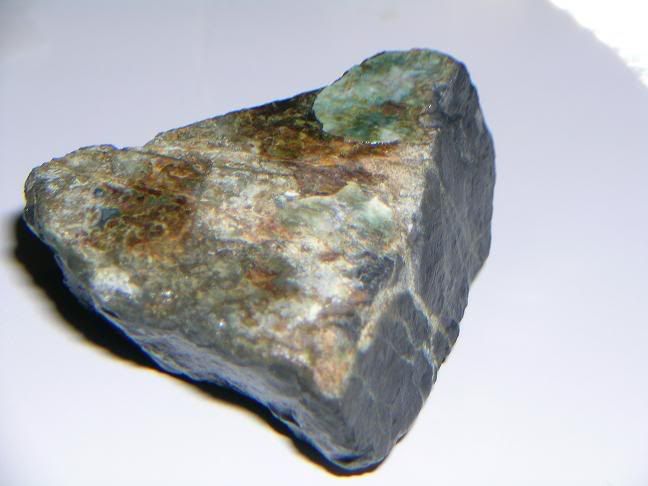
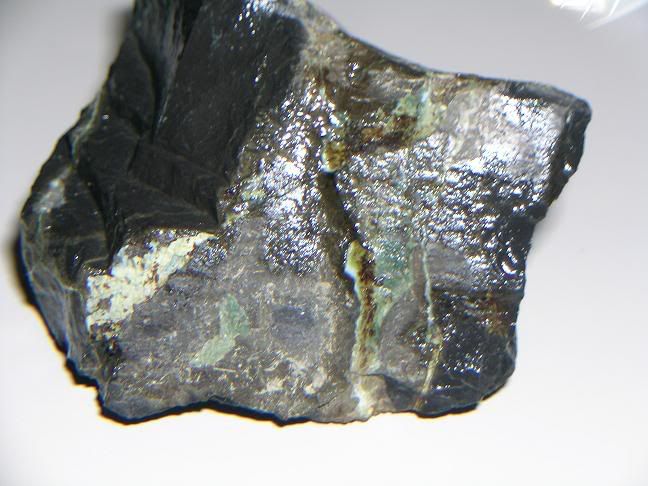
Here's what I found at my mine's tail  . It's a coal mine so I assume this is coal as the matrix, but I only assume that because it's black. Anyway it's got green veins running through it almost like a marble of some kind. This is what one of the driveways to an old quarry is lined with, there was much more than I could pick up but I sure tried.    Peace, SSSSpaceman SSSpliff |
|
jerryb
spending too much on rocks
 
Member since January 2006
Posts: 408
|
Post by jerryb on Feb 9, 2006 7:21:47 GMT -5
its not coal, but beyond that...
jerry
|
|
greenmann
spending too much on rocks
 
Member since August 2005
Posts: 325
|
Post by greenmann on Feb 9, 2006 18:17:16 GMT -5
My guess would be basalt. Most of the Cascades is a mix of granite and basalt bedrock. Columbia Basalt is often blackish. Seems to be hard enough to tumble all right... but we'll see if mine shines up or not. Might also be shale, since shale is often associated with the coal deposits here, but it doesn't look flaky like shale usually is.
|
|