|
|
Post by 1dave on Apr 19, 2017 15:15:26 GMT -5
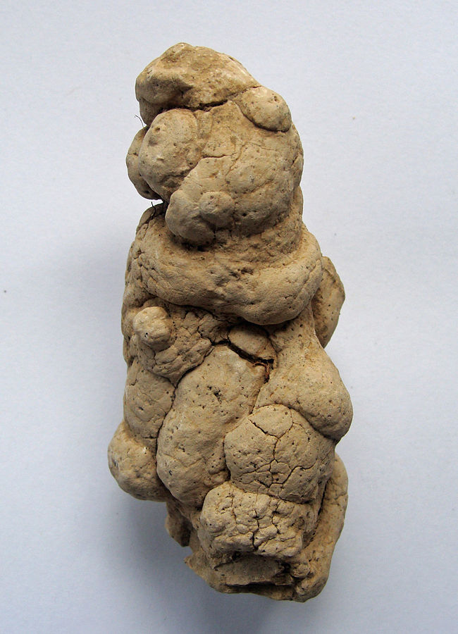
mohs roused my interest in this unusual material though the book "The Lost Cities of Cibola".  Petersen pointed out serious errors in the "Wind Blown" interpretation for their creation. 1. Loess is a geologically recent deposit that buries pre-existing landscape like a blanket from up to 300 feet thick as a massive uniform deposit. 2. "Loess" means loose, used because the material is extremely porous - exceeding 50%. In other words More than half it's bulk is vacant! 3. It has a tendency to cleave along vertical planes to form bluffs. This is because undisturbed loess is perforated with countless mainly vertical capillary tubes. How were they formed? Not by wind blown silt!  4. 4. The loess of Iowa is filled from top to bottom with snail shells and angular (not wind nor water worn!) pebbles!  5. 5. Odd dried clay nodules throughout that could not be wind blown..  So if not by wind or water, nor compacted by gravity, how were they formed?
|
|
|
|
Post by melhill1659 on Apr 19, 2017 20:20:42 GMT -5
The bluffs may not have been deposited there by wind but could they look like that from wind erosion??? Your thoughts?
|
|
|
|
Post by 1dave on Apr 19, 2017 21:08:05 GMT -5
Wind and water. Water takes it away quickly - faster than any other kind of soil.
Petersen wracked his brains trying to figure out how they were formed - slow comet particle impact, 4th dimension, but that does not explain the snail shells. Perhaps very large tornado or water spout?
|
|
|
|
Loess
Apr 19, 2017 21:25:19 GMT -5
1dave likes this
Post by mohs on Apr 19, 2017 21:25:19 GMT -5
That Aeolian theory is really mind boggling A more sober account (but no loess boggling) is from Walter Alvarez book “A Mostly Improbable Journey” What a great title ! It explains where the sand that formed the sandstone in the Colorado Plateau came from. This sandstone is in area called Ruby Canyon It is a beautiful pink hue. Good rock’n heart material. (Whoever ever goes hounding there  ) Scientist figure the sand was deposited some 200 mya. And where did this sand come from? The Appalachian Mountains! That's pretty loess ! They can tell by the dating of zircon crystals in this sandstone. The only source rock to account for the age of these sands Comes from eastern United States. Well that my interpretation of the facts. I’d get the book to get a different interpretation. What the wind can carry may surprise. What can fall from the sky, in mass quantity, in short period of time, into a small area ? The sky is falling? Well maybe the Papago’s are an example ? A Most Improbable Journey Mostly - slow comet particle impact, 4th dimension,  Yep the 4th Dimension, loess caliches, and Yellow soil and not from where the huskies go  |
|
|
|
Post by toiv0 on Apr 19, 2017 22:14:41 GMT -5
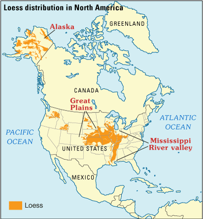
for a guy who likes a little more clay content in his soil the Loes is not your friend. Iowa, central Illinois and points between.
|
|
|
|
Loess
Apr 19, 2017 23:44:22 GMT -5
1dave likes this
Post by mohs on Apr 19, 2017 23:44:22 GMT -5
 The book does talk about clay (or lack thereof) in the loess but I think in China its mostly caliche Petersen wracked his brains trying to figure out how they were formed - slow comet particle impact, 4th dimension, but that does not explain the snail shells. Perhaps very large tornado or water spout? You ask a good question Dave One I was wondering about I thought Petersen theory was going off swimmingly until the snails came up some of his reasoning seemed forced to conform to his theory the only time he used Occam razor was when he was slicing those snails up with his observations. Pretty intense ! but the theory certainly wasn't the simplest explanation... mostly
|
|
metalsmith
Cave Dweller 
Member since October 2012
Posts: 1,537
|
Post by metalsmith on Apr 20, 2017 3:02:09 GMT -5
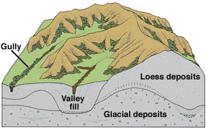
In the first image in the thread, there is a landscape with erosional features such as 'gulley' and these are subject to 'valley fill'. From an aeolian formation mechanism perspective, the loess would effectively be raining fine soil dust down onto a landscape. The setting for this would have to be generally dry for the dust to form, but there is no requirement for the entire landscape to be devoid of water. I suggest the snail shells and larger clasts are the result of alternative erosional mechanisms: glacial / fluvial and their environments (see Fig 3 here). The angularity of clasts is reduced with exposure to the erosional agents. At or close to the source of the material and the point of entry even fluvial sediment can be highly angular. ETA Evidence for a windblown origin of loess In order to explore the Neogene evolution of East Asian winter monsoon circulation, grain-size analysis was conducted on the Neogene Sikouzi section, Guyuan, Ningxia, China, a relatively monsoon-sensitive region. The results show that most of the particles are fine, the sand-bearing samples (median grain size [Md] >63 μm) are less than 6.4%, and that all the grain-size distribution curves of representative samples have a similar pattern to those of eolian dust sediments on the Chinese Loess Plateau. Rare earth element (REE) patterns of eight samples from the Sikouzi section are all characterized by light (L) REE enrichments, relatively flat heavy (H) REE patterns, and slight negative Eu anomalies, similar to those of loess and the average upper continental crust. These lines of evidence point to a windblown origin of the Sikouzi fine sediments. sourceFluvial role in loess deposition Rivers are essential for loess deposit formation. River systems which relate directly to loess deposit formation include the Danube and the Rhine; the Mississippi and the Missouri; the Thames and the Medway; the Indus, Ganges and Brahmaputra; the Dnepr, Don and Volga; the Clutha, Mataura and Rakaia—New Zealand rivers; the Yellow River; rivers in South America; Siberian rivers (flowing north); the Odra and the Wisla (between the mountains and the ice); the Syr-Darya and Amu-Darya (into the desert) sourceRole of fluvial transport agents for loess in England A complex series of events in the Weald loess trap causes a concentration of loess material by rivers flowing through various gaps in the Downs. The Thames provides loessic estuarine deposits, and the Pegwell Bay loess was a feature of the Stour. South coast accumulations are related to rivers flowing south through Downs gaps, such as the Adur and the Arun. sourceLoess is not necessarily simply aeolian The ‘known’ distribution of loess in the UK cannot be accounted for under simple aeolian transportation and dumping of silt sized material, its distribution is too sporadic. Therefore the distribution is controlled by the geomorphic surroundings, processes and even in some cases several phases of reworking and redistribution sourcePeriglacial setting of loess On the Yorkshire Wolds the loess was deposited before the ice reached its extreme limit, as it is incorporated in a chalky, flinty head beneath the till. sourceThe role of freezing / freeze-thaw / cryoturbation New sedimentological evidence is presented for phases of accretion with two distinct units, a calcareous brickearth exhibiting periglacial cryoturbation sourceRole of reworking of loess Most loess has been modified to some degree by local reworking, bioturbation and syn-depositional weathering, but a process of ‘loessification’ is not necessary for a dust deposit to qualify as loess. The terms ‘primary loess’ and ‘secondary loess’ have previously been used to described wind-deposited loess and redeposited loess, respectively, but it is more accurate to describe material reworked and redeposited by non-aeolian processes as ‘loess-derived colluvium’ or ‘loess-derived alluvium’. sourceInfluences on Chinese loess the Chinese Loess Plateau has evolved as a more dynamic landform than previous thought, where wind deflation, fluvial input, lateral transport, and accumulation of sediment are equally important sourceLacustrine Himalayan loess In the Kashmir valley the Quaternary geological record is preserved in the form of exposed Karewas (ancient lake beds), capped by loess. sourceSimplicity ... ahhh! |
|
|
|
Loess
Apr 20, 2017 4:48:32 GMT -5
1dave likes this
Post by MrP on Apr 20, 2017 4:48:32 GMT -5
1dave another great topic. What an amazing world we live in...................................MrP
|
|
|
|
Loess
Apr 20, 2017 10:26:02 GMT -5
Post by 1dave on Apr 20, 2017 10:26:02 GMT -5
metalsmith, Great information! - But it does not account for the long capillary tubes, empty spaces, odd clay masses, nor the snails. What I like about the waterspout idea is water between the particles that later dried out accounts for the spaces. Air bubbles rising accounts for the tubes, mud balls slammed together in the wind accounts for the odd clay found. Oh, and also the snails. It does not account for the huge volume.
|
|
metalsmith
Cave Dweller 
Member since October 2012
Posts: 1,537
|
Loess
Apr 20, 2017 12:26:55 GMT -5
1dave likes this
Post by metalsmith on Apr 20, 2017 12:26:55 GMT -5
metalsmith, Great information! - But it does not account for the long capillary tubes, empty spaces, odd clay masses, nor the snails. What I like about the waterspout idea is water between the particles that later dried out accounts for the spaces. Air bubbles rising accounts for the tubes, mud balls slammed together in the wind accounts for the odd clay found. Oh, and also the snails. It does not account for the huge volume. 1dave you have a great mind for information. Consider then the volumes of sand in the Taklamakan, Mongolian Steppe and Tengger deserts. It is the winnowing of these sediments that produces loess in China that exceed 300m thick in places. Now that is volume indeed! Without source or observation I would suggest that the tubes are more likely to be accounted for by differential cementation by percolating soil-water than water-spouts. By what mechanism would the water-spouts defy gravity? In the UK, I'm aware that the brickearths are accompanied by calcite crystals; these would dissolve in carbonic acid (rain water+CO2) although what stimulates the precipitation, I'm not sure: there is an inverse temperature relationship with Calcite in solution (assuming temperature decreases with depth); perhaps saturation and ion-exchange with the clays is sufficient. I don't know if you have clarity on whether the snails are terrestrial or aquatic? As per my previous post, though, I suggest the snail shells are the result of alternative landscapes such as gully-fill or lacustrine (if aquatic) loess depositional areas or washed in by fluvial mechanisms. Do 'mud balls slammed together in the wind' have a modern equivalent / analogous environment? I wonder how pervasive these are or whether they are a local phenomenon? I would look to the local environment to explain the creation of the clay-balls in a local context before extrapolating it across the global loess deposit terrains. |
|
|
|
Loess
Apr 20, 2017 12:52:00 GMT -5
Post by 1dave on Apr 20, 2017 12:52:00 GMT -5
metalsmith, I've also considered very heavy windstorms that convert to torrential rains.
|
|
metalsmith
Cave Dweller 
Member since October 2012
Posts: 1,537
|
Loess
Apr 20, 2017 13:46:41 GMT -5
1dave likes this
Post by metalsmith on Apr 20, 2017 13:46:41 GMT -5
metalsmith, I've also considered very heavy windstorms that convert to torrential rains. Would the torrential rains not serve to collapse the open macro-porous structure typical of loess and converting to flow, lead to the recognised fluvio-sedimentary features such as current ripples, dunes and lower and upper stage plane-beds? See bedforms phase diagram, fig 5-12 hereActually, I'd be interested to know what bedforms are present in loess. |
|
|
|
Loess
Apr 20, 2017 15:11:32 GMT -5
Post by 1dave on Apr 20, 2017 15:11:32 GMT -5
metalsmith, I've also considered very heavy windstorms that convert to torrential rains. Would the torrential rains not serve to collapse the open macro-porous structure typical of loess and converting to flow, lead to the recognised fluvio-sedimentary features such as current ripples, dunes and lower and upper stage plane-beds? See bedforms phase diagram, fig 5-12 hereActually, I'd be interested to know what bedforms are present in loess. We are on the verge of talking about lahars. Connect this thread to forum.rocktumblinghobby.com/post/921993The hills around Phoenix appear to be covered with a thick mud like loess. Most odd. |
|
metalsmith
Cave Dweller 
Member since October 2012
Posts: 1,537
|
Post by metalsmith on Apr 20, 2017 16:01:34 GMT -5
If this report is reliable,then Barnes Buttes is partially comprised of tuff, which is aeolian. However, it is different to loess by virtue of particle size, the effect of winnowing and the proximal source where loess can be remote. Also, through the semi-molten state of tuff ash-fall tends to lend to welding together of the particles so that the resulting rock is much more dense. I have some English tuff to hand. I can get a photo at the weekend. |
|
|
|
Post by mohs on Apr 20, 2017 16:30:16 GMT -5
Wow!! now this is getting thick as the melted mud crust of the Papago's I like it  Recall that I mentioned about the government land? No access! National armory? hhhhmmmmmm…… Unfortunately what buried at Barnes Butte in Phoenix is classified. Top secret! Even Petersen couldn’t get in to inspect the melt! Perhaps I’ll try….  |
|
metalsmith
Cave Dweller 
Member since October 2012
Posts: 1,537
|
Loess
Apr 20, 2017 16:52:10 GMT -5
mohs likes this
Post by metalsmith on Apr 20, 2017 16:52:10 GMT -5
Wow!! now this is getting thick as the melted mud crust of the Papago's I like it  Recall that I mentioned about the government land? No access! National armory? hhhhmmmmmm…… Unfortunately what buried at Barnes Butte in Phoenix is classified. Top secret! Even Petersen couldn’t get in to inspect the melt! Perhaps I’ll try….  |
|
|
|
Post by rockpickerforever on Apr 20, 2017 17:19:04 GMT -5
Wow!! now this is getting thick as the melted mud crust of the Papago's I like it  Recall that I mentioned about the government land? No access! National armory? hhhhmmmmmm…… Unfortunately what buried at Barnes Butte in Phoenix is classified. Top secret! Even Petersen couldn’t get in to inspect the melt! Perhaps I’ll try….  Wrong Barnes Butte, metalsmith. That one is located in Prineville, OR. |
|
|
|
Loess
Apr 21, 2017 9:30:03 GMT -5
mohs likes this
Post by 1dave on Apr 21, 2017 9:30:03 GMT -5
I think I found the answer - posted in the Phoenix thread with pictures. I agree with the scientists on loess beginning source, but for me more is required for loess creation than just wind. For me that just results in another sand dune. Just wind and gravity leaves no voids, creates no tubes, creates no clay balls. A huge dust storm colliding with an overhead hundred year rain storm = unprecedented Mud Fall! What happened at the Phoenix location, for granite buttes to be covered with mud and huge rocks is at the edge of imagination. I doubt anything like that has been seen anywhere else on earth. Seems to have happened around 1680.  |
|
|
|
Loess
Apr 21, 2017 10:44:58 GMT -5
1dave likes this
Post by mohs on Apr 21, 2017 10:44:58 GMT -5
I think the answer to age of the buttes is bound up with erosion issue/
what I can't understand is why the buttes are granite breccia's ?
why not just solid granite like most mountains ?
|
|
metalsmith
Cave Dweller 
Member since October 2012
Posts: 1,537
|
Post by metalsmith on Apr 25, 2017 1:26:20 GMT -5
Wrong Barnes Butte, metalsmith. That one is located in Prineville, OR. Ok - thanks for clarifying ... does this help? Hopefully in the right place this time. |
|


 )
) 


