|
|
Post by 1dave on Apr 10, 2018 9:17:05 GMT -5
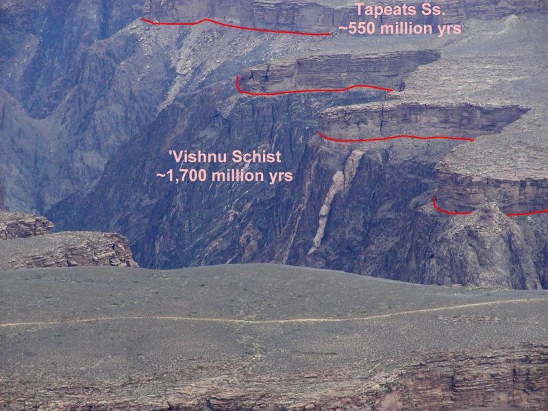
 For the past week I've been studying Upheaval Dome and Robert's Rift by Moab Utah. When did it happen?  There are clues. 1. The top rocks lifted and tilted have been long eroded away, but huge blocks of Navajo Sandstone remain.  Rocks uplifted in the center of the crater date back to the Cutler Formation.  A cross-section prepared after Gene Shoemaker examined the site provides great insight.   2. A short distance after leaving US 191 onto State Road 313 this curious wavy formation comes into view. In most of the rest of the area this has long since been eroded away. What caused the waves and when?   What did the area look like back then?  Lehi Hintze of BYU provided data on the area. Mid Jurassic was about 150 million years ago.  Each of the red arrows I've added point to unusual "Disturbances in the Force." Each of the red arrows I've added point to unusual "Disturbances in the Force."Consider the Salt Wash Member of the Morrison Formation when SUDDENLY "sand pods" filled with vanadium, uranium, petrified wood, and dinosaur bones appeared.  There have been many, beginning with The Great Unconformity, when 1,150 million years of history was washed away!  |
|
|
|
Post by 1dave on Apr 14, 2018 12:27:26 GMT -5
I've been wondering when the Upheaval Impact happened and tried to narrow it down. To the northwest was the Sundance Sea. Did it record any vibrations?  It mohs defiantly did! Check out Boundary Ridge in Idaho and Wyoming pubs.usgs.gov/pp/0540/report.pdf- about the same time of the Page Sandstone Thousand (water) Pocket sandstone,Stump Firmation, Carmel Formation, The Curtis Formation, The San Rafael Group, the Salt Wash Member of the Morrison Formation, etc. which is all a BIG jumble.   Boundary Ridge Member :Unit# Name, Description ---------------------------------------------------Thickness in feet Boundary Ridge Member :Unit# Name, Description ---------------------------------------------------Thickness in feet16. Limestone, oolitic, slightly sandy, yellowish-gray;weathers pinkish gray; forms ledge_________ 2 15. Siltstone, sandy, soft, yellowish-gray------------------------------------------------------------------ 6 14. Claystone, soft, medium-gray------------------------------------------------------------------------- 18 13. Covered ------------------------------------------------------------------------------------------------ 24 12. Limestone, dense to granular, yellowish-gray,vuggy, partly brecciated ; forms cliff __________ 11 11. Siltstone, soft, reddish brown____________________________________________________ 25 10. Limestone, thin-bedded to shaly, slightly sandy,granular light-yellowish-gray,poorly exposed__ 36 9. Limestone, thin- to medium-bedded, brownishgray; weathers light yellowish gray; forms low ridge; makes sharp contact with underlying unit--------------------------------------------------- 52 8. Limestone, thick-bedded (beds %-6 ft thick),oolitic, medium-brownish-gray; weathers yellowishgray ; forms prominent ridge; Camptonecte common on bedding surfaces_____________ 727. Siltstone, soft, sandy; yellowish gray at top, becoming greenish gray at bottom;
overlain abruptly by massive oolitic limestone along an undulating bedding plane; grades into underlying unit_____________________________________________________________________ 5
6. Siltstone, soft, sandy, purplish-to reddish-brown;contains some green streaks near base 6
5. Siltstone, thin-bedded to shaly, calcareous, slightly sandy ; exhibits some crossbedding; yellowishgray at top, becoming greenish gray at base; surfaces wavy and crenulated; makes sharp· contacts with adjoining units____________________________________________94. Siltstone, soft, yellowish-gray ----------------------------------------------------------------------------1 3. Siltstone, soft, brownish-red________________________________________________________ 5 2. Siltstone, soft, yellowish-gray----------------------------------------------------------------------------- 3 1. Claystone, thinly laminated, silty, soft, mediumgray, crinkled ---------------------------------------10 Total thickness of Boundary Ridge Member____________________________________________ 285 It is tough to get those columns to line up! The bottom layer of Boundary Ridge got crinkled, layer 5 got wavy and crenulated and sandy. 6 became more sandy and started changing color, but by 7 big changes are happening, suddenly covered with a 72 foot layer, then 52 feet more from layer 8! |
|
pizzano
Cave Dweller 
Member since February 2018
Posts: 1,390
|
Post by pizzano on Apr 14, 2018 13:11:06 GMT -5
I've been wondering when this happened and tried to narrow it down. To the northwest was the Sundance Sea. Did it record any vibrations?  It mohs defiantly did! Check out Boundary Ridge in Idaho and Wyoming - about the same time of the Page Sandstone Thousand (water) Pocket sandstone,Stump Firmation, Carmel Formation, The Curtis Formation, The San Rafael Group, the Salt Wash Member of the Morrison Formation, etc. which is all a BIG jumble.   Boundary Ridge Member :Unit# Name, Description -----------------Thickness in feet Boundary Ridge Member :Unit# Name, Description -----------------Thickness in feet16. Limestone, oolitic, slightly sandy, yellowish-gray;weathers pinkish gray; forms ledge_________ 2 15. Siltstone, sandy, soft, yellowish-gray------------ 6 14. Claystone, soft, medium-gray------------------- 18 13. Covered -------------------------------------- 24 12. Limestone, dense to granular, yellowish-gray,vuggy, partly brecciated ; forms cliff _________ 11 11. Siltstone, soft, reddish brown__________________ 25 10. Limestone, thin-bedded to shaly, slightly sandy,granular light-yellowish-gray,poorly exposed_ 36 9. Limestone, thin- to medium-bedded, brownishgray; weathers light yellowish gray; forms low ridge; makes sharp contact with underlying unit---------- 52 8. Limestone, thick-bedded (beds %-6 ft thick),oolitic, medium-brownish-gray; weathers yellowish gray ; forms prominent ridge; Camptonecte common on bedding surfaces___________________ 72 7. Siltstone, soft, sandy; yellowish gray at top, becoming greenish gray at bottom; overlain abruptly by massive oolitic limestone along an undulating bedding plane; grades into underlying unit______ 5
6. Siltstone, soft, sandy, purplish-to reddish-brown;contains some green streaks near base_______ 6
5. Siltstone, thin-bedded to shaly, calcareous, slightly sandy ; exhibits some crossbedding; yellowishgray at top, becoming greenish gray at base; surfaces wavy and crenulated; makes sharp· contacts with adjoining units___________________________ 94. Siltstone, soft, yellowish-gray------------------ 1 3. Siltstone, soft, brownish-red____________________ 5 2. Siltstone, soft, yellowish-gray------------------- 3 1. Claystone, thinly laminated, silty, soft, mediumgray, crinkled ------------------------------ 10 Total thickness of Boundary Ridge Member____ 285 I had looked up Mylonite awhile back thinking I may have found that occurrence in Utah.........still not sure.......here's a link I saved.....:
myweb.facstaff.wwu.edu/talbot/cdgeol/Structure/Mylonite/Mylonite.html
Sure seems to cover a lot of ground.....and flavors....!
|
|
|
|
Post by 1dave on Apr 14, 2018 16:15:41 GMT -5
I copied a bunch of Rock columns, clipped them to the Jurassic sections, and pasted them all into one huge image. Rockshow took it! it shows how the Jurassic changed from place to place   |
|
|
|
Post by 1dave on Apr 14, 2018 16:40:09 GMT -5
That didn't work as well as I hoped. The image got reduced too much. Here are the individual columns. Idaho Jurassic all washed away  Northeastern Utah underwater. Twin Creeks deposited on Navajo - here named Nugget.  We are "Stumped" at Flaming Gorge.  Really Stumped at the Dinosaur Monument.  East of Vernal on the Colorado border.  At the San Rafael Swell.  Grand Junction Colorado.  Hanksville  |
|
|
|
Post by 1dave on Apr 15, 2018 20:35:01 GMT -5
I made a drawing trying to understand this impact. From the center of the crater to the nearest edge of Robert's Rift is just under 5 miles. A lot of overburden has eroded away. Could that edge have been the edge of the impact?  I still don't see how that could open up a fracture over 30 miles long. Something does not compute. I played around trying to make a fit using Purdue's excellent program. www.purdue.edu/impactearth/  Crater size is about right  But something is really wrong with the fallout. Only a dusting at 100 miles? 500 miles away in the Sundance Sea the annual accumulation had been ~ 5 feet of silt. suddenly it jumped up to 72 feet! What Happened? Let's look at that data again! From 5 feet to 72 feet in one year, 52 more feet the next year, then 36, 25, 11, 24, 18, and back to normal 7 years later! That is a lot of fallout! |
|
|
|
Post by 1dave on Apr 15, 2018 20:56:27 GMT -5
This all happened on top of the San Raphael group - Curtis - Summerville - Entrada - etc. sed.utah.edu/Stop4_1.htm .jpg) Figure 1: Figure 1B, A model of internal sedimentary structures pictured in Figure 1A: 1 - A thin basal bed plus overlying, gently dipping laminations, interpreted as ACCELERATION PHASE. 2 - Topset laminations passing over a brinkpoint to foreset laminations, MAXIMUM VELOCITY. 3 - Sigmoidally curved parallel lamination, DECELERATION PHASE. |
|
|
|
Post by 1dave on Apr 15, 2018 22:15:58 GMT -5
Looking a little closer to the impact site we find the Salt Wash Member of the Morrison Formation by Thompson, north of Moab. This was part of the Morrison Lake, the Tidwell Member being deposited. Suddenly the Salt wash Member arrived. At the bottom is fine sand and tiny bits of wood and bone. Then bigger bits of wood and bone. Then whole logs a hundred feet long, vegetation and more bone - all radioactive! Miners were finding Roscoelite and Carnotite in the area. Four parts Vanadium to 1 part Uranium. Later they realized they had been overlooking tantalum and niobium. What else have they overlooked? Elements so far identified are:  What an interesting collection! |
|
|
|
Post by 1dave on Apr 15, 2018 22:20:39 GMT -5
Have I whetted your Interest Yet? Jeremy Irons Quote:  |
|
|
|
Post by 1dave on Apr 16, 2018 17:11:50 GMT -5
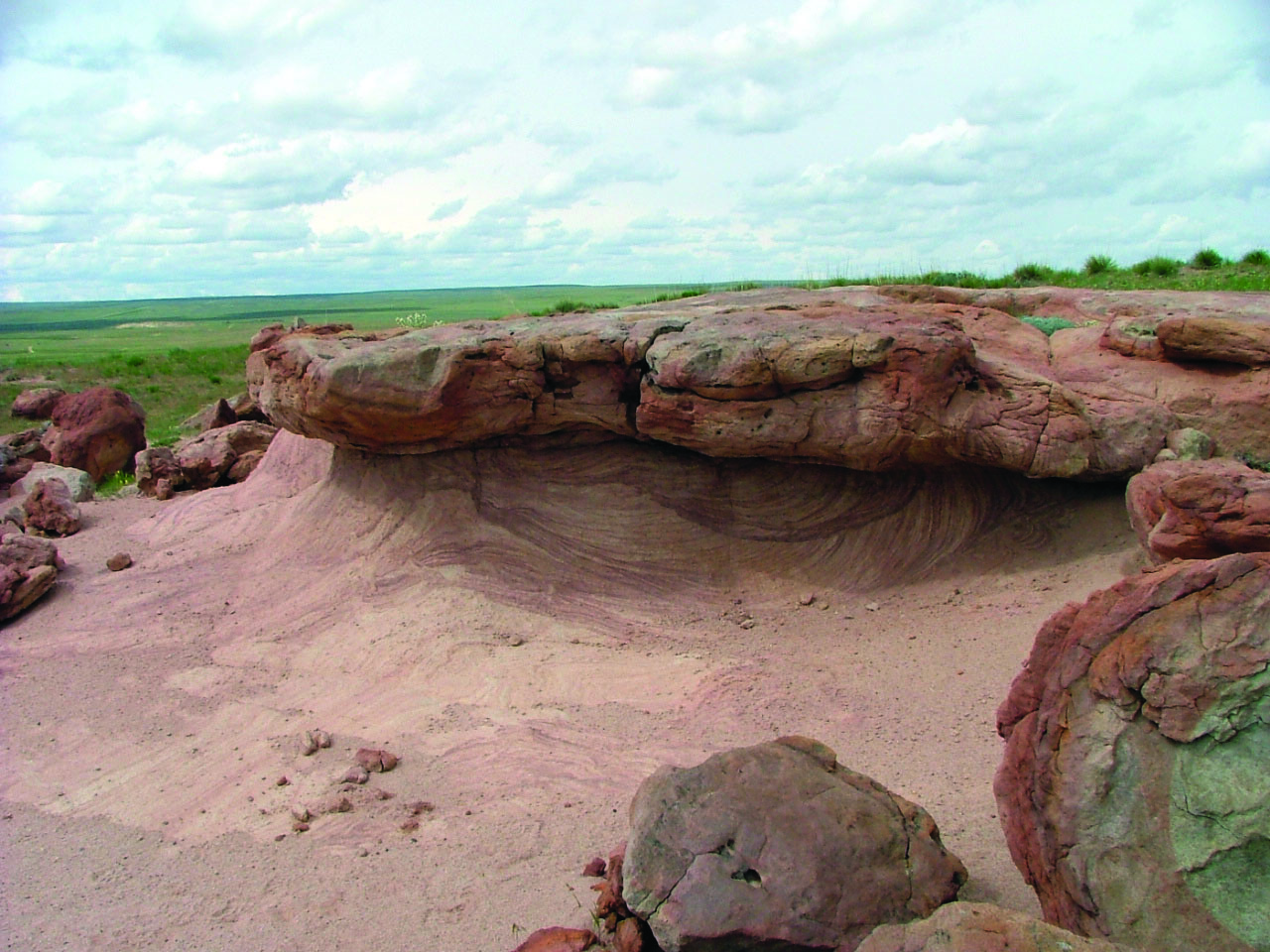
Meanwhile, back at Page Arizona, Something weird was happening to the sandstone. John Westley Powell Named it "Thousand wells." Today it is known as Thousand (water) Pockets.  Harris wash is where billions of Moqui marbles are rolling down into the Escalante river and into the bottom of Lake Powell. Don't dare pick one up because that would stop the process, - and no one in their insane mind would want that. Another look at the falling sand:  South and west of Page things started heating up. A - Early Page, B - Middle Page, C - Late page. Early Carmel.  Quit a mess our little impact is making. - MORE TO COME! |
|
|
|
Post by 1dave on Apr 17, 2018 10:36:37 GMT -5
Just how extensive is this Roscoelite, Carnotite infestation of the Salt Wash Member of the Morrison formation? I came across this curious map of "Buying Stations." And then I found this map of the Carnotite thus far found in the Morrison Formation. That is a LOT of Vanadium and Uranium from one little impact crater!  It is becoming obvious something substantial happened 154 million years ago. It is becoming obvious something substantial happened 154 million years ago.Here is a brief description : |
|
|
|
Post by fantastic5 on Apr 17, 2018 11:41:49 GMT -5
1dave - very interesting! I used to think I was smart....now my head just hurts. Uranium rich asteroid impact? Naturally occurring nuc? Dinosaur duck and cover? But if the Purdue mock up does not support an impact event, was this some sort of internal disturbance in the force? Mud volcano on a grand scale? Or some other internal cataclysmic event? Roberts rift some kind of subduction zone? All I know is I know nothing! And knowing a very little bit is even worse 
|
|
|
|
Post by 1dave on Apr 17, 2018 15:30:34 GMT -5
Many sites are run by elitist types that want to know if you are one of them before they are willing to share. A great source of information on the Morrison Formation is: wyomingpaleo.org/references/Turner-Peterson_synthesis.pdfAxis - an imaginary line about which a body rotates. Jurassic Time- "Kimmerrigian Time does NOT refer to Kemmerer Wyoming.  icon_think What does radioactivity hve to do with evolution? |
|
goatgrinder
spending too much on rocks
  Make mine a man cave
Member since January 2017
Posts: 368 
|
Post by goatgrinder on Apr 17, 2018 18:25:54 GMT -5
Yeah my head hurts too. I think I'll just go along with the nice colors.
|
|
|
|
Post by 1dave on Apr 17, 2018 23:10:12 GMT -5
Although I disagree with THEIR interpretations, ALL the facts are there, especially in the charts, graphs, and diagrams. I am sorely tempted to share them with you through RockShow. Reading the entire report is worth your time, but most of you won't, so here at least are their conclusions. I've bolded the (to me) most outstanding comments. wyomingpaleo.org/references/Turner-Peterson_synthesis.pdf |
|
|
|
Post by grumpybill on Apr 18, 2018 11:12:14 GMT -5
Sure. There you go making me look up words and terms again...
|
|
|
|
Post by 1dave on Apr 18, 2018 11:23:54 GMT -5
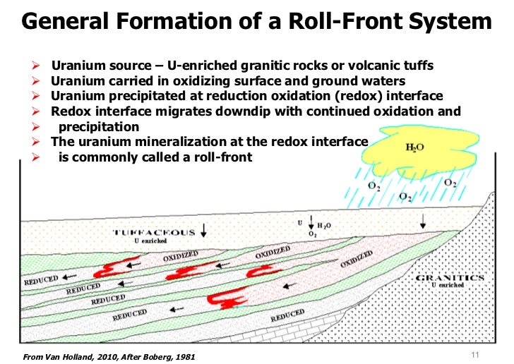
As good as the above report is, How did they completely ignore the vanadium/uranium mining in the area?  Take a close look at paradox valley in the above image. Note the wavy line from northeast to southwest? That is the Delores River (Rio Dolorosa - river of sadness) that gave the Paradox valley it's name. The river drains the area to the southwest north to the Colorado River, but WHY does it cross the valley instead of running through it? That is the paradox. Back to the image. All the white is the Morrison Formation, the 45 degree lines is where the Morrison has been eroded away. The grey is the "UraVan" Mineral Belt where most of the Vanadium and Uranium is found in it's curious "ROLLS" Why so circular?      |
|
|
|
Post by 1dave on Apr 18, 2018 11:54:55 GMT -5
Present Geological Thinking   Looking at a "roll."  QUESTION: IF the uranium was coming out of decomposing granite, WHY did it begin AND end with the Salt Wash Member? WHY didn't it continue to accumulate in the overlaying Brushy Basin and other upper layers? QUESTION: IF the uranium was coming out of decomposing granite, WHY did it begin AND end with the Salt Wash Member? WHY didn't it continue to accumulate in the overlaying Brushy Basin and other upper layers? |
|
|
|
Post by 1dave on Apr 18, 2018 12:06:42 GMT -5
A uranium mine near Moab Utah.  EDIT 4/19/2018 EDIT 4/19/2018 - I forgot to include these cross-section images of the turbulence involved with the Salt Wash Member emplacement -apparently AFTER Brushy Basin Member had begun.   Compare to the Thousand Pockets Sandstone above. |
|
|
|
Post by 1dave on Apr 19, 2018 11:47:35 GMT -5
Almost immediately after the "Uravan" Mineral belt occured, the hot dry area was covered by a new body of water - Lake T'oo'dichi' - and the forming - ( Authigenesis is the process whereby a mineral or sedimentary rock deposit is generated where it is found or observed. Such deposits are described as authigenic.) - of albite that cemented everything together. www.minsocam.org/ammin/AM56/AM56_1403.pdf Note that the lake is surrounded by "active uplifts" - Zuni Uplift, Monument Uplift, and the Umcompahgre Uplift! That would account for the sudden 7 year jump in the amount of sediment reaching the Sundance Sea!!! |
|


.jpg)


