|
|
Post by 1dave on Apr 19, 2018 18:38:44 GMT -5
Two final parallel GROOVY CLUES.Excuse the delay. I just remembered to include two images in forum.rocktumblinghobby.com/post/992776/threadThe two grooves are clearly visible on google Earth.  Some Quick Measurements reveal that they are about 30 miles apart from center of groove to center of groove, the northeast groove is about 25 miles wide, and the southwest groove is about 20 miles wide.  The southwest groove carved out the Paradox Valley and sucked up the salt and over-lying layers just as Upheaval Dome and Robert's Rift did.   It lines up with Upheaval Dome, Robert's Rift, and was responsible for the Zuni Uplift, the Monument Uplift, and the San Rafael Swell.  The other groove carved out Eagle basin and was responsible for the Umcompaghre Uplift. Both were responsible for opening Robert's Rift AND the trough later followed by the Colorado River. Also, the land mass they landed on slid on the salt layer to the north.  Both grooves were filled up by lake sediments which explains the paradox of the Dolored River crossing Paradox valley instead of following it. 
|
|
|
|
Post by 1dave on Apr 20, 2018 18:56:24 GMT -5
|
|
|
|
Post by fernwood on Apr 21, 2018 5:12:29 GMT -5
Thank you for another excellent post. I had to read this three times to comprehend (I think) what a unique phenomenon happened and the resulting effect. Will probably be coming back to this one some more for a better understanding.
|
|
|
|
Post by 1dave on Apr 28, 2018 11:25:29 GMT -5
|
|
|
|
Post by 1dave on Apr 30, 2018 21:28:08 GMT -5
I just found this map of where our uranium came from State Number of mines Tons of ore produced!  |
|
|
|
Post by 1dave on May 2, 2018 16:03:00 GMT -5
When I first visited Upheaval Dome the Park Rangers were determined to convince everyone that it was a salt dome. I just made this image that shows conclusively it never could have been. The Paradox Formation is at least 3000-5000 feet (almost a mile) below the rocks that were sucked up into the crater center. The image makes it obvious how much material has eroded away as the impact occurred in the Salt Wash Member of the Morrison Formation. 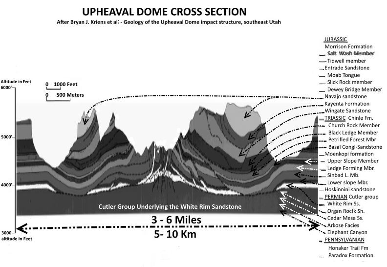 The crater size depends on which rings they count - How much washed away? |
|
|
|
Post by 1dave on May 3, 2018 8:51:18 GMT -5
Here is this whole thread in a nut shell:  The "VanUraTantNiobium" 160 mile diameter (A = πr 2 = ~ 20,000 square miles) portion of the Salt Wash Member appeared in an instant. Melt water from the comet flooded the area, washed the contaminated logs and vegetation along the flood channels, and created Lake T'oo'dichi', which contaminated the lands of northern New Mexico and Texas. Water converted some of the uranium into autunite - (hydrated calcium uranyl phosphate) with formula: Ca(UO2)2(PO4) 2· 10-12H2O is a yellow - greenish fluorescent mineral with a hardness of 2 - 2 1⁄2. Autunite crystallizes in the orthorhombic system and often occurs as tabular square crystals. - which soaked into so much of our agate + d-bone, pet wood and made them fluoresce green. QUESTION: How much did all that radiation affect the local mutations? Dinosaurs dying of radiation sickness? |
|
|
|
Post by 1dave on May 3, 2018 9:03:48 GMT -5
 The surrounding coma contaminated most of the Rocky Mountains.  |
|
|
|
Post by 1dave on May 3, 2018 10:49:28 GMT -5
The Magic of Ron Blakey, NAU, allows a fantastic view of the area through time. Note the starling change that happened between 150-145 Ma. In triassic Times drainage was to the west, then as the land was tilted in the Jurassic it shifted to the northwest, then north east, and finally ended up to the southeast for a while. jan.ucc.nau.edu/rcb7/jurpaleo.html
|
|
|
|
Post by 1dave on May 4, 2018 11:06:23 GMT -5
Did all these uplifts in southeastern Utah take place at the same time? 
Were impact shock waves responsible for sandstone weaknesses for forming Arches National Park? 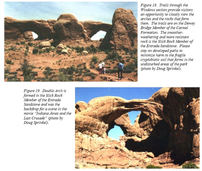 Most of the guesses revolve around the Paradox salt deep below, but www.utahgeology.org/road_logs/uga-29_first_edition/NP_guide/arches.pdf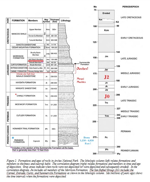 Hellmut H. Doelling Hellmut H. Doelling of the Utah Geological Survey, Salt Lake City, Utah did such a great job in this PDF that I am going to present it in a separate post. 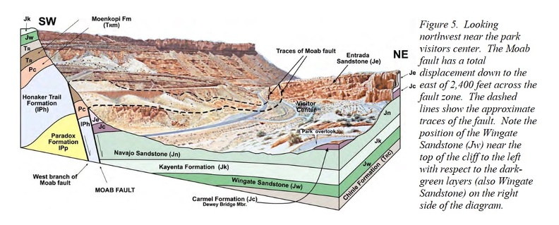
Dinosaur National Monument  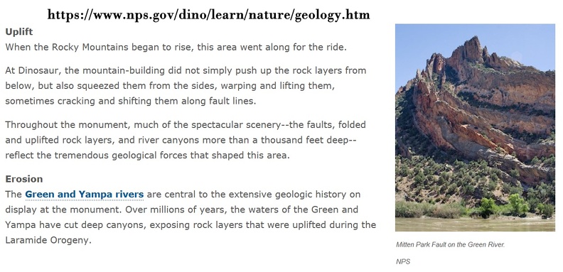 |
|
|
|
Post by 1dave on May 4, 2018 12:29:57 GMT -5
|
|
|
|
Post by 1dave on May 4, 2018 19:48:06 GMT -5
Fall out - the Final Clue.A-A' is in Wyoming.  J0 J0 is the erosional surface ending the Triassic Chinle Formation and the beginning of the Jurassic Wingate sandstone. J2 is the erosional surface ending the Navajo Sandstone and the beginning of the Carmel/Curtis/Entrada/Summerville/Page/Morrison/etc. formations. 
|
|
|
|
Post by 1dave on May 12, 2018 14:12:07 GMT -5
|
|
RWA3006
Cave Dweller 
Member since March 2009
Posts: 4,633 
|
Post by RWA3006 on Sept 10, 2020 20:50:05 GMT -5
I just read this thread once again and boy, there's a lot of food for thought. I certainly have very few answers, but sure enjoy pondering what happened through the eons. Thanks 1dave for the thought provoking info. |
|
|
|
Post by 1dave on Sept 10, 2020 21:10:10 GMT -5
I just read this thread once again and boy, there's a lot of food for thought. I certainly have very few answers, but sure enjoy pondering what happened through the eons. Thanks 1dave for the thought provoking info. Hopefully this winter I'll find time to do some research on how all that radiation changed the genetics of the creatures that lived there from before to after. |
|
RWA3006
Cave Dweller 
Member since March 2009
Posts: 4,633 
|
Post by RWA3006 on Sept 10, 2020 21:43:35 GMT -5
I just read this thread once again and boy, there's a lot of food for thought. I certainly have very few answers, but sure enjoy pondering what happened through the eons. Thanks 1dave for the thought provoking info. Hopefully this winter I'll find time to do some research on how all that radiation changed the genetics of the creatures that lived there from before to after. No need, Dave. We all know it simply made their coprolites glow.  |
|