|
|
Post by 1dave on Jul 29, 2018 14:37:51 GMT -5
|
|
|
|
Post by 1dave on Jul 29, 2018 14:38:25 GMT -5
|
|
|
|
Post by mohs on Jul 29, 2018 15:09:45 GMT -5
Thanks Dave
ya save me a trip
even though it only mile or two down that rocky road
my car over heat
no refer
and it hot & humid about
I did make it Burton Barr yesterday
and did some more studying
on the Lost City of Cibola
hard to follow Peterson
when he indicates that
a river, canal, Hohokam settlement
were on the east side of the buttes
but he does mention Indian Bend Wash
which present possibilities
tell your grand son
welcome to Phoenix
heck of time to be here
I almost worked for State Farm
at the 52nd St facility
they had there major print operations there...
|
|
AzRockGeek
has rocks in the head
  
Member since September 2016
Posts: 703
|
Post by AzRockGeek on Jul 29, 2018 15:19:24 GMT -5
Traveled these roads more then a few times when I use to live at 52/McDowell and 68th/McKellips. Never gets old viewing the area.
Thanks for posting, don't get out that way much any more since I moved a little further east.
|
|
|
|
Post by mohs on Jul 29, 2018 16:17:40 GMT -5
I don’t know Dave
The whole area is a mystery
From the elevated ground
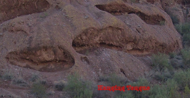
To the pockmarks
Such a strange anomaly
|
|
|
|
Post by mohs on Jul 29, 2018 16:20:55 GMT -5
what would be interesting is some drone video
of the caves
I'll have to look into that....
|
|
|
|
Post by 1dave on Jul 30, 2018 1:54:34 GMT -5
|
|
|
|
Post by fernwood on Jul 30, 2018 7:02:45 GMT -5
Thanks for the trip.
|
|
|
|
Post by mohs on Jul 30, 2018 14:08:36 GMT -5
Ha ha Geologist goes to great length to disprove Peterson’s Comet Loess Theory. Encasing fine grains of Pagago breccia in resin, sanding smooth with different grits of sandpaper and then polishing the grains using 5.0 µm and 3.0 µm aluminum powder. The grains were also coated carbon to prevent electron discharging! The samples were then placed under JEQL JXA 8600 Electron Microprobe. The microprobe was equipped BSE & WDS. We can conclude the spectrograph was precise. And the conclusion is: that tiny grains of calcium carbonate (but not salt) causes a chemical reaction that blows out matter forming the pockmarks? They even came up with new name for the tongues: Rock Meal ! Well Peterson would call that Tafoni Baloney! the real cause of the pockmarks en.wikipedia.org/wiki/Great_Papago_Escape |
|
|
|
Post by 1dave on Jul 30, 2018 15:54:53 GMT -5
Tafoni Baloney!
Agreed!
I am amazed at the number of articles that say the buttes are sandstone!
I live surrounded by thousands of feet of sandstone.
There isn't a grain of sandstone in all of Phoenix!
|
|
|
|
Post by 1dave on Jul 31, 2018 2:46:46 GMT -5
|
|
|
|
Post by mohs on Jul 31, 2018 14:40:28 GMT -5
I can concur with the analysis that
South Mountain Metamorphic Kinematic Complex
is the bedrock that the buttes sit upon.
Mr S J Reynolds alludes to that in this fine statement
I cannot abide though- that the pediment the buttes sit upon
were formed by some detachment of a South Mountain rock slide.
That is not where the redbeds, breccias and clastic come from.
So the question becomes:
Were the buttes established and, some underground plutonic event,
(associated with the South Mountain Metamorphic Kinematics Complex),
uplift those buttes?
Or
Was the bedrock already established,
and some other event as yet undetermined,
-terrestrial or extra terrestrial-
deposit the breccia & clastic that build up those buttes?
mostly
|
|
|
|
Post by 1dave on Jul 31, 2018 17:30:08 GMT -5
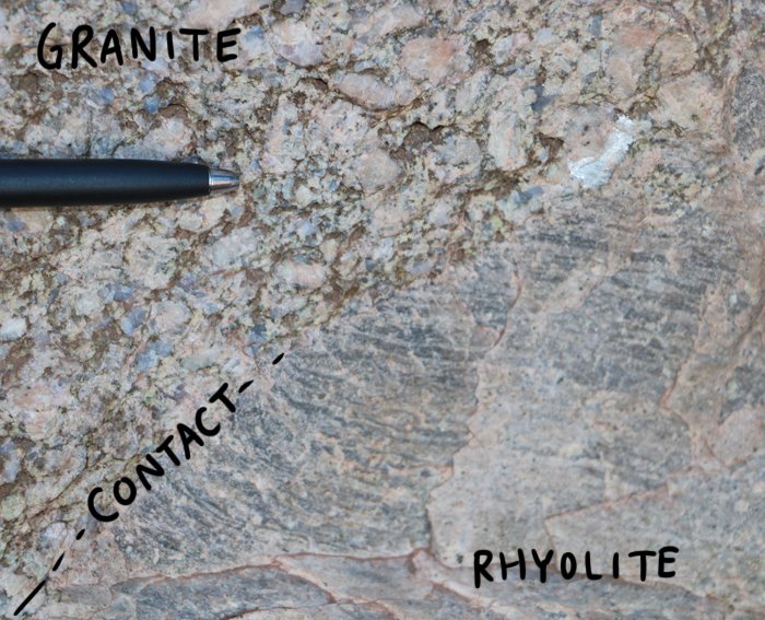
That is what I'm trying to establish now mohs. I believe the buttes themselves are ancient granite with two layers of landslide coatings. The southwest half of south Mountain is ~1.5 billion year old granite that was metamorphosed to gneiss. The northeastern half is 25 million year old granite. in the middle is 22 million year old granite that caused the northeast corner to brecciate. Something later caused the outer layer to brecciate again making two layers, the outer layer finer than the inner. That would provide the two slides. The first slide was MOSTLY rhyolite. The second slide was MOSTLY granite. So far I haven't found of there being any rhyolite on South Mountain. Perhaps most of it was removed with the first slide, and the rest with the second? Now, does the granite in the Barnes Butte Breccia match the granite from South Mountain? Earthquakes? www.tucsonnewsnow.com/story/17203031/history-of-earthquakes-in-arizona |
|
|
|
Post by mohs on Aug 1, 2018 11:15:01 GMT -5
Another hypothesis to explain the unique features of the buttes Especially the sediment encrusted clastic material So strange The buttes looks like a Biblical proportion mudflow that just froze in time/ And the remaining buttes are the last weathered remnants. Catastrophic mudflow, landslide, rock & roll are all intuitive. But that may be an illusion Just as the earth appears to be a sphere but is actually flat Easy to be deceived So the hypothesis states that The South Mountain Metamorphic Kinemathic Complex up lifted the sediment fill of the Valley basin. The buttes are the valley sediment exposed. Weathered & oxidized., This deep sediment was up lifted by a plutonic thrust during the Kinemathic Complex. No mudslide or rocknroll needed. Just deep earth exposure But No ! There is a problem with the ingenious theory The sediment fill of the valley is not filled with clastics. Amazing how relatively rocks free the soil in the Valley is. Well at least for many feet of digging. This photo is of an archeology dig that makes my point to an extent. 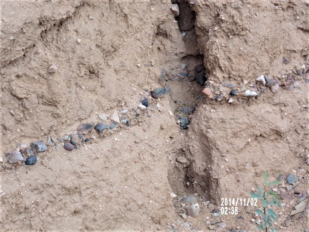 The excavation was at a Hohokam site 2 miles west of the Papago. The dig was at least 8 feet deep. This band of exposed rocks are at least 4 feet down from the surface. No clastics! Just a band of stones in rich soil. Which is why I took the picture. Another strange phenomena. But my hypothesis may still be saved This plutonic thrust brought the material up from deep in the Valley basin Deep! Hundreds of feet deep. In those depths clastics may reside So that is what is exposed in the buttes/ Yet you may ask:  ‘O’K mohs-- where do those clastics come from'? Well obviously there was catastrophic mudflow & mountain disintegration rock n roll event that occurred eons previously... |
|
|
|
Post by 1dave on Aug 1, 2018 12:23:16 GMT -5
mohs I envy you being on site! Seeing things in person that I will never get to see.
|
|
|
|
Post by mohs on Aug 2, 2018 21:18:35 GMT -5
Thanks Dave ! I'll see if I can't fix the connection it was video taken about 10 years ago of the big horn sheep in Papago the quality not all that great but it is historical...mostly They have been trying to reintroduce Big Horn into the Superstition Wilderness Range yo 1dave ! see if it play now |
|
|
|
Post by 1dave on Aug 4, 2018 19:43:48 GMT -5
Yes, it played.
Famous amethyst mine?
|
|
|
|
Post by mohs on Aug 4, 2018 20:15:20 GMT -5
had always heard about the amethyst mine
Obviously I’ve never been up there
others on the board might have
I have no samples
Its always been a mystery
Maybe others on the board have some to show ?
There is a lot of info on the net about it
I post this video
just because of the killer view
Of the Sonora desert
|
|
|
|
Post by 1dave on Aug 4, 2018 22:53:29 GMT -5
AMA-ZING!
|
|
|
|
Post by mohs on Sept 9, 2021 23:56:04 GMT -5
wow this is really a cool thread it needs morviews whos' cool dude in the you tube ? hire him! he needs a job i;ll be back on a camelsback  |
|

