|
|
Post by 1dave on Jun 4, 2019 6:45:14 GMT -5
|
|
Deleted
Deleted Member
Member since January 1970
Posts: 0
|
Post by Deleted on Jun 4, 2019 10:42:37 GMT -5
Those fault lines give a good idea of how the state is rotating. Looks like I'm sitting overlooking an old fault that connects with a recent fault across the road a ways.
|
|
|
|
Post by 1dave on Jun 4, 2019 18:42:20 GMT -5
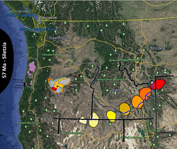
57 Ma A hotspot formed the Hawaii sized island of Siletz that crashed into and became the western part of Oregon 50 Ma. As the continent continued to move over the hotspot, supervolcanoes began appearing above it, moving southeast through Tillamook(48 Ma), Madras (35 Ma) - Richardson Ranch! - etc. spouting up Thundereggs as it went, hit the Oregon/Nevada border for McDermitt(16 Ma), Owyheea(13), Bruneau (12 Ma), then northeast to Twin Falls (10 Ma), Spencer Opal (6 Ma), and present Yellowstone (0.6 Ma). It is not done on it's back trail. 7 million years ago southeastern Oregon was blanketed with the Rattlesnake Tuff that has spheroids and lithophysae in it. filepickup.wrd.state.or.us/files/studies/harney_gw_study/Selected_References/Streck_1994%20Rattlesnake%20Tuff.pdf We owe a lot to Siletz!  |
|
halitedigger
starting to spend too much on rocks
  Lost in the Mojave, Sierras or Itoigawa
Member since September 2013
Posts: 104 
|
Post by halitedigger on Jun 5, 2019 4:53:33 GMT -5
Thanks for posting this 1Dave. Just back from Japan and have Jet lag so nothing better to do. I'm a dealer in Japan and recently have been getting interested in the Owyhee Mountains, Spencer Opals and the various minerals up in Nevada, Oregon, Utah, Idaho & Montana. Awesome material.
|
|