|
|
Post by 1dave on Mar 21, 2021 8:55:51 GMT -5
 en.wikipedia.org/wiki/Kasha-Katuwe_Tent_Rocks_National_Monument en.wikipedia.org/wiki/Kasha-Katuwe_Tent_Rocks_National_MonumentKasha-Katuwe Tent Rocks National Monument is a U.S. National Monument located approximately 40 miles (64 km) southwest of Santa Fe, New Mexico, near Cochiti Pueblo. Managed by the Bureau of Land Management (BLM), it was established as a U.S. National Monument by President Bill Clinton in January 2001. Kasha-Katuwe means "white cliffs" in the Pueblo language Keresan.[2] The monument is a unit of the BLM's National Conservation Lands. Geology Kasha-Katuwe is located on the Pajarito Plateau between 5700 and 6400 feet (1737–1951 m) above sea level. The area owes its remarkable geology to layers of volcanic rock and ash deposited by pyroclastic flow from eruptions within the volcanic field of the Jemez Mountains that occurred 6 to 7 million years ago. These rock layers are assigned to the Peralta Tuff. Many of the layers are light in color, which is the origin of the monument's Keresan name. Over time, weathering and erosion of these layers has created slot canyons and tent rocks. The tent rocks are composed of soft pumice and tuff. Most of the tent rocks have a distinctly conical shape and some retain their caprocks of harder stone. The tent rocks vary in height from a few feet to 90 feet (27 m).[2] |
|
|
|
Post by orrum on Mar 21, 2021 9:39:58 GMT -5
Good one Dave.
|
|
|
|
Post by 1dave on Mar 21, 2021 10:22:28 GMT -5
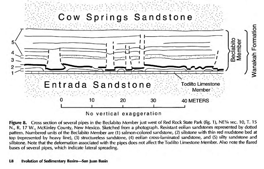
Could these have grown on top of 140 Mya sandstone pipes - ponds of underground water being driven up with later quakes from various sources? ORIGIN OF PIPES - Time of Origin Whatever the origin of the pipes, several types of evidence indicate a relatively early origin during the Jurassic, before the beds were lithified. The preserved tops of a few pipes within Jurassic units indicate that the pipes reached the ground surface during the Jurassic (Hilpert and Moench, 1960; Schlee, 1963; Moench and Schlee, 1967). We designed a series of simple experiments in which the cohesive strength of the material was varied by changing its degree of water saturation. The experimental apparatus consisted of a 5-gallon paint bucket (30 cm diameter) and a small can (7.5 cm or 2.5 cm in diameter). The bucket was cut open on one side and covered with a removable wall to allow a window for viewing the structure at the end of the experiment (fig. 1 IA). In the bottom of the bucket a hole was cut just large enough to allow the can to slide through. The experiment was begun by raising the can approximately 5.5 cm (4 cm for the smaller of the two cans) through the hole in the bottom of the empty bucket. The bucket was filled loosely with alternating thick layers of a light-colored, medium-grained sand, similar to that found in pipes in the study area, and thin layers of a dark, fine-grained sand to delineate the pattern of deformation produced during the experiment (fig. 1IA). The can was then slowly (over a period of several minutes) lowered flush to the bottom of the bucket so as to cause gradual collapse of the overlying sand. Finally, the bucket was turned on its side while a partial lid was put on the top of the bucket to keep sand from spilling out, the upward-facing removable wall was taken out, and sand was scraped away by a long spatula or machete to allow a view of the resulting deformation in a cross section through the sand.   |
|
|
|
Post by 1dave on Mar 21, 2021 11:02:03 GMT -5
|
|
|
|
Post by toiv0 on Mar 22, 2021 9:04:27 GMT -5
You can pick up apache tears and maybe a shark tooth not too far away
|
|


