jamesp
Cave Dweller 
Member since October 2012
Posts: 36,154
|
Post by jamesp on Mar 5, 2022 14:17:49 GMT -5
This is one way I find artifacts. Humans leave a trail. In this case 1000's of little white chips. Sometimes they are dark and not so visible. If not brightly colored then sift samples of the creek bottom looking for thin chips. It takes a 100 chips to make a point... So I find a plowed field or timbered property and look in the creek adjacent and downstream of it(if it is near a creek). In this case the chips of chert are white and show up in the photo. This is a photo of a creek bottom with a clearing upstream from it. Nature does not make chips like this(or rarely). So I conclude chert debitage is present and the clearing above the creek had Native occupation. It boils down to being a detective of sorts. And a rock analysis can be performed, perhaps the creek is full of chert or flint. A valid supply for making arrowheads. But thin high speed chips are the work of humans. 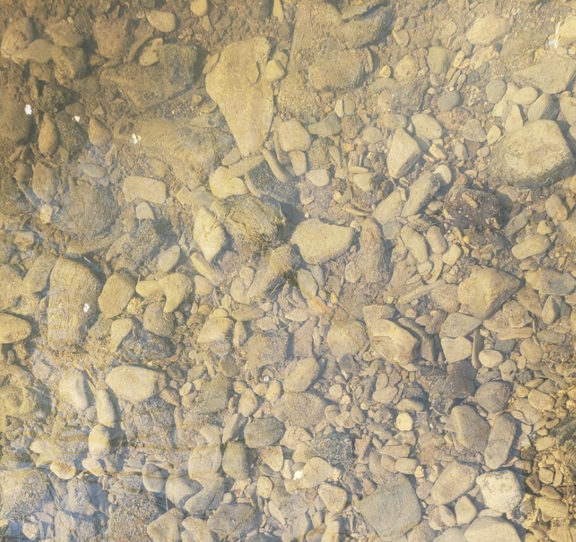 |
|
|
|
Post by liveoak on Mar 5, 2022 14:33:03 GMT -5
That's interesting Jim, you're right it's detective work, obviously you've been doing it for awhile. My husband Tom has always done that with topos to find nice secluded rivers & lakes to go on, over the years. Obviously you're taking it a step further with your eyes on the bottom.
A lot of leg work- but it looks like you've been successful over the years- so well worth it.
We'll watch the water levels in the Withlacoochee & the Swannee- maybe with any luck later this summer.
Oh- we're actually south of Chipley, FL , in Washington county.
Our hobby website is called Live Oak Studios .
Patty
|
|
jamesp
Cave Dweller
Member since October 2012
Posts: 36,154
|
Post by jamesp on Mar 8, 2022 1:11:41 GMT -5
That's interesting Jim, you're right it's detective work, obviously you've been doing it for awhile. My husband Tom has always done that with topos to find nice secluded rivers & lakes to go on, over the years. Obviously you're taking it a step further with your eyes on the bottom.
A lot of leg work- but it looks like you've been successful over the years- so well worth it.
We'll watch the water levels in the Withlacoochee & the Swannee- maybe with any luck later this summer.
Oh- we're actually south of Chipley, FL , in Washington county.
Our hobby website is called Live Oak Studios .
Patty
You guys are close to White Springs and Valdosta. The Suwannee and Withlacochee around those towns is coral rich. Please consider those as targets. Let's cross fingers for low water. It looks like I will be exploring SW Alabama next. It is new to me. Looking for fossils and artifacts for the most part. Close you, I hope to find some sites to share. South west of Montgomery the smaller creeks say 10 to 20 feet wide are loaded with quartzite pebbles. These creeks fill fast and drain fast so they are not 'shut down' by heavy rain seasons since they drain quickly for collecting between rains. May be something for you guys to check out, bring hammers to open the quartzite cobbles. The creeks loaded with quartzite look like this on google earth, but so do creeks with sand banks. It's a short trip for you guys to explore. Somewhere closer to Atlanta is the source for all this quartzite, it will be in layers. I will be seeking the layered stone soon. quartzite cobbles, note time slider in upper left corner of google earth. So the creek can be viewed at low water during other years to see rock bars. Probably 20 miles SW of Auburn. 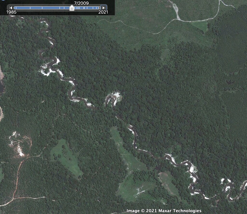 |
|
jamesp
Cave Dweller
Member since October 2012
Posts: 36,154
|
Post by jamesp on Mar 8, 2022 1:43:47 GMT -5
One of many creeks sampled on road trip across south and mid Alabama. In Marengo County. Creek was solid limestone bottom and loaded with bivalve(clam)innards(a limestone mold between two clams. Closer look reveals the actual fossil shells at next rock bar downstream. 82mm21 Sponge damaged Oyster, two quahog equals, cockle clam, others. about 3". Should be a goldmine for fossils, best one sampled.  |
|
jamesp
Cave Dweller
Member since October 2012
Posts: 36,154
|
Post by jamesp on Mar 8, 2022 1:52:48 GMT -5
Lake Wheeler falling back down. 16 days up, about a record ! Got another unseasonably sunny warm next week of 3/14 to 3/18. Lake scheduled at lowest from 556 down to 551 then. Pounding rain should have cleaned mud/silt off them artifacts ! Pumped. Predicting success. 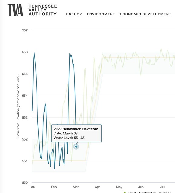 |
|
jamesp
Cave Dweller
Member since October 2012
Posts: 36,154
|
Post by jamesp on Mar 10, 2022 11:00:15 GMT -5
Dang am I striking out, another heavy rain and lake is heading back up. Need 551 to 552, lake is already up to 554 and rising. grrr It was at 551 for a whole 3 hours !  |
|
jamesp
Cave Dweller
Member since October 2012
Posts: 36,154
|
Post by jamesp on Mar 23, 2022 15:05:00 GMT -5
Conditions were finally good to make the trip to the Elk River in north Alabama. Last time there was 12 years ago. This section of the Elk River is backed up by a dam downstream. Many encampments are underwater and untouched by collectors. Apparently the shores are well picked over because there was not an arrowhead to be found on the surface. But lightly raking thru the gravel along the shore at a known ancient encampment produces some finds. The best find was a large knife blade broken in half - ouch. The 3 large items are scrapers. 4 whole points. 4 middle sections. And 2 broken points. 1 serious heartbreaker that would have been a find of a lifetime. 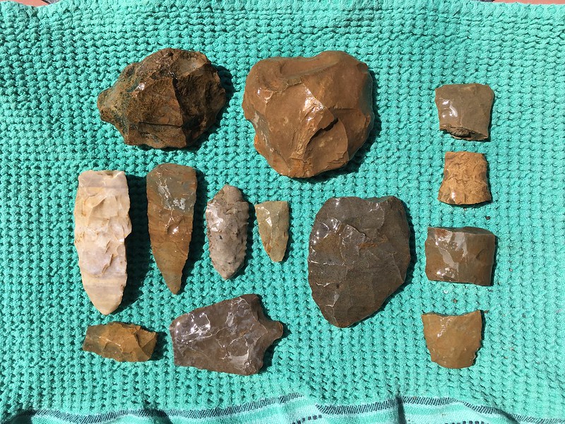 Unfortunately a fine knife blade that would have been 7 to 9 inches long was found broken. Such blades are were found in burials and may have served in ceremonial activities. It takes great skill to make such a large blade. The rock it was chipped from had to be large. They didn't have slab saws back then.  These are chert chips of they left behind. Some appear heat treated. These chips locate the encampments. Common rule, no chips no points except for a rare field find. At the bottom is quartzite that was available for making arrowheads in the southern side of the state. Very little quartz in the north part of the state and little chert in the south half. Chert of this higher quality is not easy to find and more colorful than the common shore gravel. 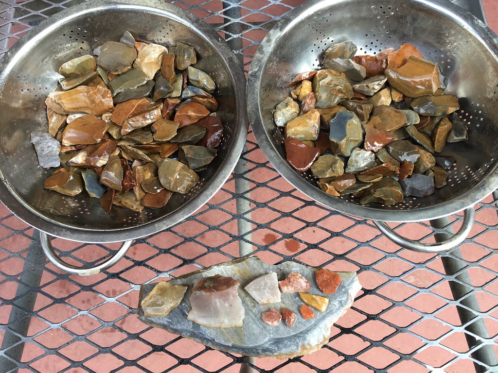 A closer look at the quartzite so common in the south half of Alabama. It occurs in veins 1 to 6 inches thick.  The Tennessee River is known for it's large clams and pearls formed in them. Likely a food source for early man.  Time was spent locating other encampments. One in particular has a high density of chips and points. They are covered with 2 to 4 inches of silt. When the water rises during the warm season the search will entail sitting in 2 feet of water in bathing suit and feeling with hands thru the gravel under the softened silt at a particular encampment with a high density of chips. The points are unusually large along the Elk River and easy to discriminate from the gravel by feel under water. The encampments had to be located by test sampling while the water was low. The silt actually hides the artifacts from beach walkers. Anxious for warm weather to move in for a return trip ! A typical ceremonial blade from images.  |
|
Sabre52
Cave Dweller
Me and my gal, Rosie
Member since August 2005
Posts: 20,456
|
Post by Sabre52 on Mar 23, 2022 17:29:21 GMT -5
Wow, very nice finds James! I used to use the rake method to find points at a campground at Clearlake, CA. Points worked their way down to bedrock where they were usually lodged on edge. Not uncommon to find 20 obsidian points in a day there. I plan to try the technique on our creek gravel beds when it warms a bit as the creek is lined with camp sites and some points have to be in the gravel. The whole knife thing is extremely frustrating here. I have a box of beautifully knapped partial knife blades but I've only found a single complete knife in 13 years. I save the brokes, hoping I will find both halves, as some of the knives must have been huge. No luck yet though. I'll have to take a pic of all the brokes.
|
|
|
|
Post by liveoak on Mar 23, 2022 18:10:05 GMT -5
Sounds like a good trip Jim, I think you're rare in the south dreaming of the heat coming on  |
|
|
|
Post by Son Of Beach on Mar 23, 2022 18:25:18 GMT -5
I came across this video a couple weeks ago, didn't know if there was any validity to his method. Basically, he shoves a stick in the mud just off the shoreline and lets it sit for a couple weeks and the water has a way of forming a divot pile around it, which in turn leads to higher number of arrowheads found.
|
|
jamesp
Cave Dweller
Member since October 2012
Posts: 36,154
|
Post by jamesp on Mar 24, 2022 7:58:09 GMT -5
Wow, very nice finds James! I used to use the rake method to find points at a campground at Clearlake, CA. Points worked their way down to bedrock where they were usually lodged on edge. Not uncommon to find 20 obsidian points in a day there. I plan to try the technique on our creek gravel beds when it warms a bit as the creek is lined with camp sites and some points have to be in the gravel. The whole knife thing is extremely frustrating here. I have a box of beautifully knapped partial knife blades but I've only found a single complete knife in 13 years. I save the brokes, hoping I will find both halves, as some of the knives must have been huge. No luck yet though. I'll have to take a pic of all the brokes. Points working there way down to a hardpan or bedrock is the trick to locating points in most situations Mel. When these large reservoirs are created by dams the wave action at various water levels can erode 2 to 4 feet of clay/soil off the exposed slopes into the deeper water leaving all the solids piled behind. This massive unnatural soil removal leaves a goldmine of artifacts behind mixed in the gravels. Figure a way to rake or feel thru that gravel and one will have success. Creeks and rivers are similar. sure you are aware there can be much more introduced gravel from upstream and the density of artifacts in river gravels can be greatly reduced. This Elk River cove of Lake Wheeler is grossly coated with 2 to 4 inches of silt due to the heavy erosion of the upstream farming along the the river. So the shoreline gravel is covered in silt which effectively covers the treasures. They are waiting to be collected. I spent a lot of hours first finding chips and then mapping out the chip zones under the silt so I could return at higher water to 'feel' thru the silt to get to the underlying gravel. The 'Elk River point' is one of the largest types in the SE US and easy to 'feel' with your hands when raking your fingers thru the gravels when covered with 1.5 to 2.5 feet of water sitting over it. The water makes the silt, the gravels and your body buoyant reducing physical effort greatly. That's my plan when warm weather returns and the lake is raised back to full pool. It's not a pretty plan but it may be effective. I cannot imagine finding 20 points a day. Never had such luck. Matching broken points ? We were amazed at how tricky that is. We had a 5 gallon bucket of broken points from a productive camp near the Etowah Indian Mounds and not one of them matched go figure. Furthermore I have only found a couple of large broken knives ever. If you have found that many you should score a whole one sooner than later. Or a half match. Photos of those finds please... |
|
jamesp
Cave Dweller
Member since October 2012
Posts: 36,154
|
Post by jamesp on Mar 24, 2022 8:16:16 GMT -5
Sounds like a good trip Jim, I think you're rare in the south dreaming of the heat coming on Yes the heat is hell Patty but snorkeling in that 72F Florida spring water is only comfortable for Codfish. Tennessee mountain water just as cold. GOT to get out of that cold water for a warm up break. Just saying, some of the best finds are found underwater. Especially in that crystal clear Florida spring water. I envy your close proximity to those spring fed rivers in the panhandle. Congrats on your return to St. Vincent. If memory serves the pass between St George Island and St Vincent was loaded with Native man's pottery shards. That would be the east shore of St Vincent. I also found out that the Aucilla River has fine fossil coral in it. There is a couple that sells small coral pseudomorphs they find at some type of a privately owned clay pit near the Aucilla. This is they: www.apalachee-minerals.com/agatizedcoral1 |
|
|
|
Post by liveoak on Mar 24, 2022 8:37:42 GMT -5
At the local flea market there used to be a couple of local divers that sold agatized coral and fossils they found in the Apalachicola river, and probably other rivers as well, pretty cheap. We're not divers- but as you say snorkeling works in shallows just fine.
Once the weather warms up (it's only still in the 70's) , we'll have to do some poking around.
Yup, we've seen the pottery on St Vincent, pretty cool.
Ya know, even if that stick poked in the water flow could do something, problem is unless you were quite local to it & could check it regularly, OR at a very remote area, it would be likely someone else would retrieve it before you.
No different then the set crawfish traps you see in the river .
|
|
jamesp
Cave Dweller
Member since October 2012
Posts: 36,154
|
Post by jamesp on Mar 24, 2022 9:15:37 GMT -5
I came across this video a couple weeks ago, didn't know if there was any validity to his method. Basically, he shoves a stick in the mud just off the shoreline and lets it sit for a couple weeks and the water has a way of forming a divot pile around it, which in turn leads to higher number of arrowheads found.
Lol Clegg's a trip. We all need his energy ! I can say that solids due accumulate around roots and stumps. Not sure why. His stick trick is new to me. He must be hunting near Ohio. Ohio is loaded with Native activity and a treasure trove for artifacts. I too found a dozen burned campfire cobbles on an island on this trip. It's not that rare considering the amount of campfires those guys built. There is a lot of collecting tricks Chad. Each site may demand a certain method. One of the more unique is sand probing in Florida where there are very few rocks. A tined probe is thrust into wet sand until it hits a rock(a clink sound), said rock is dug out from the end of the tines. In most cases it is a piece of glass or brought in chert. Hopefully a chert point. Commercial fisherman in central Florida taught me the probing method. They have wide pitchfork like probes maybe 15 inches wide with about 15 tines. They would be out in the lake probing the bottom of the lake where the shore had eroded away leaving artifacts. They supplemented their fishing income by selling their finds. I had seen a few spearheads they sold for up to $5000. Got a link on a probing trip to man-made Lake Rodman Florida. Another Florida lake loaded with sand yet no rock other than imported chert or glass trash. I designed a 'gatling gun probe' for getting around roots and stumps similar to Clegg's stick method. The commercial fisherman were impressed with 'grasshopper's' probe lol. Check it out, 4 hours probing along 20 feet of Rodman shoreline. There is a 500 gallon per second spring in the lake bottom about 100 feet out in the lake bottom where I am probing the shore. An old timer told me this spring was there before the lake was created in 1970.(few knew). Fresh spring water was miles away from each other.: www.flickr.com/photos/67205364@N06/sets/72157685915194525The circle in the water on the left is a small lime clay indian mound with a little 2" diameter spring on east side.(doubt anyone knew). The circle on the right with the semi-circle shore line is the spring funnel. The oblong circles are artifact rich shoreline good for collecting/probing. Found over 100 whole points here. Probably 1000's left behind. This was a property I owned.: 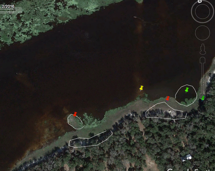 |
|
jamesp
Cave Dweller
Member since October 2012
Posts: 36,154
|
Post by jamesp on Mar 24, 2022 9:30:13 GMT -5
At the local flea market there used to be a couple of local divers that sold agatized coral and fossils they found in the Apalachicola river, and probably other rivers as well, pretty cheap. We're not divers- but as you say snorkeling works in shallows just fine.
Once the weather warms up (it's only still in the 70's) , we'll have to do some poking around.
Yup, we've seen the pottery on St Vincent, pretty cool. Ya know, even if that stick poked in the water flow could do something, problem is unless you were quite local to it & could check it regularly, OR at a very remote area, it would be likely someone else would retrieve it before you.
No different then the set crawfish traps you see in the river .
Check out the sand probing method above liveoak. It should work for you in your sand country. a welder is required to weld 1/8" music wire to a header bar, then a hollow thin wall metal conduit handle for sound magnification. Another trick is to 'cut' the sand by dragging a sharp machete attached to a rake handle across the sand surface. When the blade digs in 2 to 3 inches and drags across chert it makes a real screeching sound. Then dig offender. There were a pair of divers that used to work the Withlacoochee River from the Ga/Fl state line to it's confluence with the Suwannee River and loaded up on incredible specimens. They too sold cheap. They need an internet site ! |
|
|
|
Post by RickB on Mar 24, 2022 9:32:02 GMT -5
[/quote]Lol I too found a dozen burned campfire cobbles on an island on this trip. It's not that rare considering the amount of campfires those guys built.[/quote] jamesp. I always check out modern day campfire rings when I'm around any body of water where modern day man camps to go hunting or fishing. People have found larger stone tools like axes and hammer stones added around modern campfires by people who just see them as another rock. I also had a friend in NC find a full groove axe in landscaping rock at his local garden center. |
|
|
|
Post by liveoak on Mar 24, 2022 9:55:50 GMT -5
Makes sense, since there are no rocks down here, anything you hit has be worth investigating.
I need to get Tom, my husband on it , he welds (among other things) .
You're full of tips & tricks-
Thanks for sharing. Patty
|
|
|
|
Post by liveoak on Mar 24, 2022 10:07:09 GMT -5
Tom wants to know what the elbow is for ?
To give an outlet so the main tube / handle doesn't fill with water  Or was it just a piece of pipe as found ??
Welders need to know 
|
|
jamesp
Cave Dweller
Member since October 2012
Posts: 36,154
|
Post by jamesp on Mar 24, 2022 11:07:04 GMT -5
Lol I too found a dozen burned campfire cobbles on an island on this trip. It's not that rare considering the amount of campfires those guys built.[/quote] jamesp. I always check out modern day campfire rings when I'm around any body of water where modern day man camps to go hunting or fishing. People have found larger stone tools like axes and hammer stones added around modern campfires by people who just see them as another rock. I also had a friend in NC find a full groove axe in landscaping rock at his local garden center. [/quote] As you well know the beauty of artifact collecting is also seeing the stone debitage left behind. Part of the fun is finding the points and tools. The topography, lack of high dry land, flat high dry land adjacent to drinking water or canoe able water, creek/river intersections, vantage points, chert veins, NE wind protected sites, distance between water sources, land bridges where large rivers are closest to each other, etc etc all play a vital role in camp locations. Once that camp is located the fun begins. Grinding and nutting stones, tools axes, chunks of hematite for ochre, quartz crystals, fine chipping debitage, pottery, campfire stones, charcoal, human teeth, points are often present. Amazing how so many people walk past fine grinding stones that are sitting upside down. My return trip to the Elk in warm water should be a real productive. Those large Elk River points are easy to find by feel when fingering thru the silt covered gravel in 2+/- foot deep water. I tested this method shortly and scored easily. Dang water was too cold to deal with. Virgin untouched stock piles of points are loaded up on the hardpan in the sites I found. Collectors have totally picked these sites dry. Gotta use your head(and back and apparently fingers)to score these days. |
|
jamesp
Cave Dweller
Member since October 2012
Posts: 36,154
|
Post by jamesp on Mar 24, 2022 12:22:06 GMT -5
Tom wants to know what the elbow is for ?
To give an outlet so the main tube / handle doesn't fill with water Or was it just a piece of pipe as found ??
Welders need to know Yes welders do need to know these things. The elbow serves two purposes, one is benign and the other is diabolical. benign purpose - Is to simply drain the water out of the handle when it is laid down in the water. Water in the handle neutralizes the needed sounds generated. diabolical purpose - For connecting a 1" 100 psi centrifugal gas pump hose to the 1" FNPT fitting for adjustable forced water flow for probing harder more packed soils. That device is 30 years old and was used back then when the EPA was not so concerned about creating silt with forced water flow. The old handle had a shut off valve just above the elbow which was removed when the laws got strict. I suggest not using forced water flow in the state of Florida unless you need Tom locked away for a while. Starting at 3 minutes this poor freezing fellow is using a gold dredge. I have a 45 pound 2" backpack artifact dredge that catches points in a basket and spits out sand and mud. However I am limited to the number of rivers that dredges are allowed these days. It sucks about three - 55 gallon drums of sand thru per hour. The sand passes and the heavy solids fall downward into a basket. Perfect for sandy Florida. Absolutely exhilarating(in warm weather !). |
|