Tommy
Administrator 
Member since January 2013
Posts: 12,647
|
Post by Tommy on Mar 18, 2022 14:35:47 GMT -5
This is down in the Rockbox Tommycraigcis I just returned from Bloody Basin with a pretty decent haul. I got some material that is superior to anything else that I have seen in the last 5 years. I'll be going back soon to try and get a bit more of this beautiful plume agate. Thanks Rick! Thats too important to let it just disappear in the chatbox. |
|
nursetumbler
Cave Dweller 
Member since February 2022
Posts: 928 
|
Post by nursetumbler on Mar 18, 2022 19:47:27 GMT -5
I wasn't there when you guys were talking about it, but Vince says he remembers someone from our club who had to go in there to rescue someone who got stranded and they said they road is rougher than hell. So is Bloody Basin. Neither one are enjoyable. I've always wanted to go down to Bloody Basin but Vince doesn't like the idea because if you get stranded in there, you're kind of screwed. Back when there was no cell service in there. Don't know if there is now, but I wouldn't go in without an ATV. The other thing you have to be careful of is flash flooding. Definitely a trek best done by multiple well prepared vehicles with towing capabilities. This is precisely why I'm wondering why I hear no mention of the road in from the bottom of the lake. It definitely exists on satellite and looks substantially shorter than either of the other two roads in - my guess is it was created (or improved) for the workers when the modern version of Sheep Bridge was built. There must be a gate or private property to cross - either that or the creek crossings are too gnarly. Does anyone know the best way to look up on a computer if it's BLM land or private property out there? Tommy My husband said to download onXhunt. It shows property lines, who owns it, contact information and if that information is current you could contact for permission. |
|
|
|
Post by drocknut on Mar 18, 2022 20:33:05 GMT -5
drocknut was that you I remember pulled your trailer into the Bloody Basin collecting area a few years ago or was that someone else? Yes, that was me. In 2017 I was going on a rock trip with some people who told me it was no problem taking my 19foot trailer back in there to camp. They even told me to take the road from Cave Creek because it was smoother. Turned out they decided it was too hot to go and didn't bother to let me know the trip was cancelled. I made it to the junction of Bloody Basin Road and camped on the side of the road. I stayed there a few days trying to figure out how to get back out and doing a little rock hounding on my own. I broke my rear stabilizer jack and the propane connection to the back bumper when I hit a random big rock on the road as I was trying to get back out of there. I do not believe everything people tell me now especially when it comes to my trailer. |
|
|
|
Post by drocknut on Mar 18, 2022 20:50:48 GMT -5
In November 2020 my friend Frank and I went to Sheeps Bridge in my 4wd pickup. It was not bad until after the intersection with Seven Springs Road and then it got really rough with boulders and sandy wash outs. There were a ton of ATV's and side by sides tearing up the road and driving like crazy people. It took a long time to get there and we didn't find much because is was nearing dark and we didn't want to get caught on that road after dark. The worst part was the off road vehicles driving too fast and not watching out for other vehicles. I wouldn't recommend the trip but if you are ambitious you might fare better than we did. I know I was sore for a day or so after the trip from all the bouncing around.  view of Sheeps Bridge (Crossing) from the road above the bridge. |
|
Tommy
Administrator
Member since January 2013
Posts: 12,647
|
Post by Tommy on Mar 18, 2022 21:48:50 GMT -5
In November 2020 my friend Frank and I went to Sheeps Bridge in my 4wd pickup. It was not bad until after the intersection with Seven Springs Road and then it got really rough with boulders and sandy wash outs. There were a ton of ATV's and side by sides tearing up the road and driving like crazy people. It took a long time to get there and we didn't find much because is was nearing dark and we didn't want to get caught on that road after dark. The worst part was the off road vehicles driving too fast and not watching out for other vehicles. I wouldn't recommend the trip but if you are ambitious you might fare better than we did. I know I was sore for a day or so after the trip from all the bouncing around. view of Sheeps Bridge (Crossing) from the road above the bridge. Thanks for the info Diane! I wouldnt go that far in if I didn't plan on camping at least a couple of nights. I would want to spend a whole day hiking out to get the lay of the land and hopefully get to material that hasnt been picked over quite as bad. Thats a beautiful photo btw. |
|
|
|
Post by mohs on Mar 18, 2022 23:10:17 GMT -5
That is a Butte of picture Diane drocknut ! Really rocks my evening This thread is. Causing me grief Never been back there It's on the bucket now Butte bucket got a hole. Who knohs tho I get  still |
|
|
|
Post by drocknut on Mar 20, 2022 18:38:37 GMT -5
That is a Butte of picture Diane drocknut ! Really rocks my evening This thread is. Causing me grief Never been back there It's on the bucket now Butte bucket got a hole. Who knohs tho I get still Thank you Ed. |
|
|
|
Post by drocknut on Mar 20, 2022 18:40:52 GMT -5
In November 2020 my friend Frank and I went to Sheeps Bridge in my 4wd pickup. It was not bad until after the intersection with Seven Springs Road and then it got really rough with boulders and sandy wash outs. There were a ton of ATV's and side by sides tearing up the road and driving like crazy people. It took a long time to get there and we didn't find much because is was nearing dark and we didn't want to get caught on that road after dark. The worst part was the off road vehicles driving too fast and not watching out for other vehicles. I wouldn't recommend the trip but if you are ambitious you might fare better than we did. I know I was sore for a day or so after the trip from all the bouncing around. view of Sheeps Bridge (Crossing) from the road above the bridge. Thanks for the info Diane! I wouldnt go that far in if I didn't plan on camping at least a couple of nights. I would want to spend a whole day hiking out to get the lay of the land and hopefully get to material that hasnt been picked over quite as bad. Thats a beautiful photo btw. You're welcome Tommy. I wish I had had more time to look when I was there but I don't want to go back unless the ride gets better. Thank, that is one of my favorite pictures of that area. |
|
|
|
Post by rockpickerforever on Mar 20, 2022 19:50:48 GMT -5
There is an old abandoned suspension bridge over the Gila River, a 20 minute drive north of Yuma, and to the west of US 95 heading to Quartzsite and points north. Built originally in 1929, then rebuilt (replaced) in 1968. Unlike the Sheep Crossing bridge, this one was not built to be used to get sheep accross, it was designed and built for vehicle use. It was replaced in 1968 after they deemed the old one no longer suitable for cars. To build the new bridge, a dam was built and the river was rerouted. The original bridge was called the McPhaul Suspension Bridge, after local Yuma resident Henry Harrison McPhaul, "the only Yuma resident who ever became an Arizona Ranger." Some people know it today as the "Bridge to Nowhere." The old bridge is 1,184 feet (361 m) long in total. Its main span is is just under 800 feet, suspended by cables. The McPhaul Suspension Bridge.   The bridge is no longer maintained, you can walk to it, but you cannot cross it. 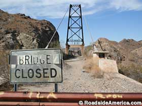  Car traveling down the dry Gila River bed. Water does flow in this river from time to time. I have seen it!  Location  The bridge is visible from US Route 95, but if you like old bridges, you really should park and get an up close look. More info HERE |
|
|
|
Post by beefjello on Mar 22, 2022 21:45:51 GMT -5
Thanks for tagging me on this Tommy I documented both trips I took out this way 14 and 12 years ago (hard to believe its been that long!). I too became.. um.. ‘obsessed’ for a while trying to find an easier way to get there (up north past Horseshoe). I realized back then that without a 4x I didn’t have much chance. forum.rocktumblinghobby.com/thread/22739/spring-break-trip-pixforum.rocktumblinghobby.com/thread/37001/spring-break-trip-lotsa-pixLike AzRockGeek said, most of the purple sagenite float was collected long ago. But from what I understand, digging in that area (just above the last switchback to the crossing) can yield some stellar results! drocknut take a look at the first pic in my second thread in comparison to yours. Yours is a much better pic, but I do believe we were standing right about the same spot  |
|
|
|
Post by drocknut on Mar 31, 2022 17:58:58 GMT -5
Thanks for tagging me on this Tommy I documented both trips I took out this way 14 and 12 years ago (hard to believe its been that long!). I too became.. um.. ‘obsessed’ for a while trying to find an easier way to get there (up north past Horseshoe). I realized back then that without a 4x I didn’t have much chance. forum.rocktumblinghobby.com/thread/22739/spring-break-trip-pixforum.rocktumblinghobby.com/thread/37001/spring-break-trip-lotsa-pixLike AzRockGeek said, most of the purple sagenite float was collected long ago. But from what I understand, digging in that area (just above the last switchback to the crossing) can yield some stellar results! drocknut take a look at the first pic in my second thread in comparison to yours. Yours is a much better pic, but I do believe we were standing right about the same spot I do believe you are right. That's a good photo spot evidently or should I say great minds think alike? :-) |
|
|
|
Post by beefjello on Apr 2, 2022 18:54:57 GMT -5
Thanks for tagging me on this Tommy I documented both trips I took out this way 14 and 12 years ago (hard to believe its been that long!). I too became.. um.. ‘obsessed’ for a while trying to find an easier way to get there (up north past Horseshoe). I realized back then that without a 4x I didn’t have much chance. forum.rocktumblinghobby.com/thread/22739/spring-break-trip-pixforum.rocktumblinghobby.com/thread/37001/spring-break-trip-lotsa-pixLike AzRockGeek said, most of the purple sagenite float was collected long ago. But from what I understand, digging in that area (just above the last switchback to the crossing) can yield some stellar results! drocknut take a look at the first pic in my second thread in comparison to yours. Yours is a much better pic, but I do believe we were standing right about the same spot I do believe you are right. That's a good photo spot evidently or should I say great minds think alike? :-) It’s gotta be the ‘Great Minds’ thing Diane  |
|
|
|
Post by drocknut on Apr 3, 2022 15:18:53 GMT -5
I do believe you are right. That's a good photo spot evidently or should I say great minds think alike? :-) It’s gotta be the ‘Great Minds’ thing Diane Yep, gotta be ;-) |
|
Tommy
Administrator
Member since January 2013
Posts: 12,647
|
Post by Tommy on Apr 3, 2022 21:04:05 GMT -5
It’s gotta be the ‘Great Minds’ thing Diane Yep, gotta be ;-) Well I think the both of you are pretty great so it doesn't surprise me a bit  |
|
|
|
Post by drocknut on Apr 5, 2022 18:31:58 GMT -5
Well I think the both of you are pretty great so it doesn't surprise me a bit I think you're pretty great too Tommy |
|
|
|
Post by beefjello on Apr 6, 2022 20:14:49 GMT -5
Well I think the both of you are pretty great so it doesn't surprise me a bit   |
|
NRG
fully equipped rock polisher

Member since February 2018
Posts: 1,630
|
Post by NRG on Apr 27, 2022 16:36:46 GMT -5
I wasn't there when you guys were talking about it, but Vince says he remembers someone from our club who had to go in there to rescue someone who got stranded and they said they road is rougher than hell. So is Bloody Basin. Neither one are enjoyable. I've always wanted to go down to Bloody Basin but Vince doesn't like the idea because if you get stranded in there, you're kind of screwed. Back when there was no cell service in there. Don't know if there is now, but I wouldn't go in without an ATV. The other thing you have to be careful of is flash flooding. Definitely a trek best done by multiple well prepared vehicles with towing capabilities. This is precisely why I'm wondering why I hear no mention of the road in from the bottom of the lake. It definitely exists on satellite and looks substantially shorter than either of the other two roads in - my guess is it was created (or improved) for the workers when the modern version of Sheep Bridge was built. There must be a gate or private property to cross - either that or the creek crossings are too gnarly. Does anyone know the best way to look up on a computer if it's BLM land or private property out there? For property ownership, I use this app on my phone. pretty impressive actually. it is made for hunters to know if they can legally hunt without permission, but there are many use cases. rockhounding is kinda like hunting in this respect. |
|
|
|
Post by realrockhound on May 23, 2022 23:41:11 GMT -5
drocknut was that you I remember pulled your trailer into the Bloody Basin collecting area a few years ago or was that someone else? Yes, that was me. In 2017 I was going on a rock trip with some people who told me it was no problem taking my 19foot trailer back in there to camp. They even told me to take the road from Cave Creek because it was smoother. Turned out they decided it was too hot to go and didn't bother to let me know the trip was cancelled. I made it to the junction of Bloody Basin Road and camped on the side of the road. I stayed there a few days trying to figure out how to get back out and doing a little rock hounding on my own. I broke my rear stabilizer jack and the propane connection to the back bumper when I hit a random big rock on the road as I was trying to get back out of there. I do not believe everything people tell me now especially when it comes to my trailer. Damn… what the hell is wrong with people. |
|