Thundereggs - Radium Springs, New Mexico
Mar 30, 2022 8:36:09 GMT -5
fernwood, hummingbirdstones, and 1 more like this
Post by 1dave on Mar 30, 2022 8:36:09 GMT -5
Radium Springs
- The Geode Kid: Robert Paul Colburn: The Formation of Thundereggs
"In 1984, I visited the map and book sales room at the New Mexico Bureau of Mines and Technology at Socorro, New Mexico. I opened geologic map 36 and found a bonanza! There are twenty one rhyolite domes along the Cedar Hills Fault 5 miles west of Radium Springs, New Mexico. The geologic maps and text of the N E and S E half of the Corralitos Ranch quadrangle was done by Russel E. Clemons in 1976. Figure 1.01 is an excerpt of this geologic map. To find your way in, you will need regular topographic maps without the formation colors printed over them. They are the Rough and Ready Hills, New Mexico 7.5 minute quadrangle and the Leasburg, New Mexico 7.5 minute quadrangle. “Short stubby flows of flow-banded rhyolite” have flowed out from some these domes, many with unaltered and altered perlite at their base, all within nine miles north and south in the Cedar Hills and Rough the Ready Hills. There are six known lithologically dissimilar thunderegg deposits, all within a couple of miles of one another. There must be many more because I have covered only a third of the outcrop margins."

I found an interesting phenomenon at this fault. I have dug and cut thundereggs from these seven different sites around this fault. All of the thundereggs from the western upthrust side of this fault are hollow,
whereas all those from the eastern down thrown side are filled solid with agate. The down thrown side of
the Cedar Hills Fault is on the east toward the Rio Grande River. Sediments from the Rio Grande and/or
its tributaries are mapped adjacent to some of these rhyolites. Later, in May, 2003, rounded cobbles were
found in-situ east of the Cedar Hills fault in Foster Canyon by Bill Anderson on a field trip with me. They were of a nature that they could have only been transported a long distance by a large river such as that of
the Rio Grande. In an area which probably remained as a desert through the ice ages, it may sound simplistic
to say that waters of the Rio Grande were responsible for filling the eggs on the down thrown side, which at
those places are about 200 feet lower than those found on the western upthrust side which, by the way, are
all hollow. However, we will visit two other sites that demonstrate this same phenomenon in Chapter 8 where
will discuss the alteration of perlite and its diagenetic products.

Secondly, it appears that here as well as in the previously described Stendel perlite deposit, thundereggs develop in flow rock instead of tuffs or ash-flow tuffs as thought by some authors (Pabian-Zarins, (1994), Ross and Smith (1961) and others. Again, unbiased by not focusing on the genesis of lithophysae, Russel Clemons (1976) comments on “geodes” in his work in the Corrolitos Ranch quadrangle: “Lithophysal and spherulitic textures are present in some of the rhyolite. Chalcedony lined geodes have formed in the flow-banded rhyolite at several locations.”
The locations for the four hollow “geodic” thundereggs on the western upthrust side of the Cedar
Hills fault are two course-grained (porphyritic) rhyolite egg deposits adjacent to each other in the southeast
quarter of section 22, Township-21-South, Range-2-West, Figure 1.02, and two fine-grained (aphanitic) egg
deposits, one in the southeast quarter of the southwest quarter of section 11, T-21-S, R-2-W, Figure 1.03
and the other is near the center of the section line of sections 34 and 35,T-21-S, R-2-W, Figure 1.04. I have
placed these specimens side by side show the differences in their matrixes. Digital photos by the author.

Then there are three solid agate-filled egg deposits on the eastern down-thrown side of this fault, two
porphyritic rhyolite deposits about 100 yards apart, probably of the same flow but with different shell and
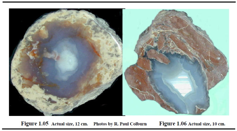
agate colors as well as core size in ratio to their rhyolite shells. These first two beds are near the center of section 25, T-21-S, R-2-W. or N320 26.830', W1060 59.608' in the Leasburg quadrangle. The decomposed perlite grades into its unaltered black glassy pristine state close to where the thundereggs thin out. Figure 1.05 is of one of these two deposits known as the Biconoid Mine. The third deposit has reddish aphanitic rhyolite shells filled with fortification and waterline agate, located just east of the scarp of the Rough & Ready Hills in the northeast 1/4 of the southeast 1/4 of section 11, T-22-S, R-2-W. or N32 0 24.462', W1070 0.718', in the Rough and Ready Hills quadrangle, Figure 1.06. Figures 1.05 and 1.06 are set side by side to show the difference of the matrixes as well as types of solid agate fills, one with fortification agate and the other with a white waterline suspension inside of blue fortification agate.

- The Geode Kid: Robert Paul Colburn: The Formation of Thundereggs

"In 1984, I visited the map and book sales room at the New Mexico Bureau of Mines and Technology at Socorro, New Mexico. I opened geologic map 36 and found a bonanza! There are twenty one rhyolite domes along the Cedar Hills Fault 5 miles west of Radium Springs, New Mexico. The geologic maps and text of the N E and S E half of the Corralitos Ranch quadrangle was done by Russel E. Clemons in 1976. Figure 1.01 is an excerpt of this geologic map. To find your way in, you will need regular topographic maps without the formation colors printed over them. They are the Rough and Ready Hills, New Mexico 7.5 minute quadrangle and the Leasburg, New Mexico 7.5 minute quadrangle. “Short stubby flows of flow-banded rhyolite” have flowed out from some these domes, many with unaltered and altered perlite at their base, all within nine miles north and south in the Cedar Hills and Rough the Ready Hills. There are six known lithologically dissimilar thunderegg deposits, all within a couple of miles of one another. There must be many more because I have covered only a third of the outcrop margins."

I found an interesting phenomenon at this fault. I have dug and cut thundereggs from these seven different sites around this fault. All of the thundereggs from the western upthrust side of this fault are hollow,
whereas all those from the eastern down thrown side are filled solid with agate. The down thrown side of
the Cedar Hills Fault is on the east toward the Rio Grande River. Sediments from the Rio Grande and/or
its tributaries are mapped adjacent to some of these rhyolites. Later, in May, 2003, rounded cobbles were
found in-situ east of the Cedar Hills fault in Foster Canyon by Bill Anderson on a field trip with me. They were of a nature that they could have only been transported a long distance by a large river such as that of
the Rio Grande. In an area which probably remained as a desert through the ice ages, it may sound simplistic
to say that waters of the Rio Grande were responsible for filling the eggs on the down thrown side, which at
those places are about 200 feet lower than those found on the western upthrust side which, by the way, are
all hollow. However, we will visit two other sites that demonstrate this same phenomenon in Chapter 8 where
will discuss the alteration of perlite and its diagenetic products.

Secondly, it appears that here as well as in the previously described Stendel perlite deposit, thundereggs develop in flow rock instead of tuffs or ash-flow tuffs as thought by some authors (Pabian-Zarins, (1994), Ross and Smith (1961) and others. Again, unbiased by not focusing on the genesis of lithophysae, Russel Clemons (1976) comments on “geodes” in his work in the Corrolitos Ranch quadrangle: “Lithophysal and spherulitic textures are present in some of the rhyolite. Chalcedony lined geodes have formed in the flow-banded rhyolite at several locations.”
The locations for the four hollow “geodic” thundereggs on the western upthrust side of the Cedar
Hills fault are two course-grained (porphyritic) rhyolite egg deposits adjacent to each other in the southeast
quarter of section 22, Township-21-South, Range-2-West, Figure 1.02, and two fine-grained (aphanitic) egg
deposits, one in the southeast quarter of the southwest quarter of section 11, T-21-S, R-2-W, Figure 1.03
and the other is near the center of the section line of sections 34 and 35,T-21-S, R-2-W, Figure 1.04. I have
placed these specimens side by side show the differences in their matrixes. Digital photos by the author.

Robert Paul Colburn: The Formation of Thundereggs
Then there are three solid agate-filled egg deposits on the eastern down-thrown side of this fault, two
porphyritic rhyolite deposits about 100 yards apart, probably of the same flow but with different shell and
agate colors as well as core size in ratio to their rhyolite shells. These first two beds are near the center of section 25, T-21-S, R-2-W. or N320 26.830', W1060 59.608' in the Leasburg quadrangle. The decomposed perlite grades into its unaltered black glassy pristine state close to where the thundereggs thin out. Figure 1.05 is of one of these two deposits known as the Biconoid Mine. The third deposit has reddish aphanitic rhyolite shells filled with fortification and waterline agate, located just east of the scarp of the Rough & Ready Hills in the northeast 1/4 of the southeast 1/4 of section 11, T-22-S, R-2-W. or N32 0 24.462', W1070 0.718', in the Rough and Ready Hills quadrangle, Figure 1.06. Figures 1.05 and 1.06 are set side by side to show the difference of the matrixes as well as types of solid agate fills, one with fortification agate and the other with a white waterline suspension inside of blue fortification agate.


