|
|
Post by 1dave on Aug 18, 2022 20:18:55 GMT -5
I predict we will have weather for the rest of the week. jamesp is concerned about the drought out west. We have been having heavy rain showers all week. For him and all Utah members here is:
waterdata.usgs.gov/ut/nwis/rtStatewide Streamflow Table Current data typically are recorded at 15- to 60-minute intervals, stored onsite, and then transmitted to USGS offices every 1 to 4 hours, depending on the data relay technique used. Recording and transmission times may be more frequent during critical events. Data from current sites are relayed to USGS offices via satellite, telephone, and/or radio telemetry and are available for viewing within minutes of arrival. All real-time data are provisional and subject to revision. Build Current Conditions Table Show a custom current conditions summary table for one or more stations. Build Time Series Show custom graphs or tables for a series of recent data for one or more stations. 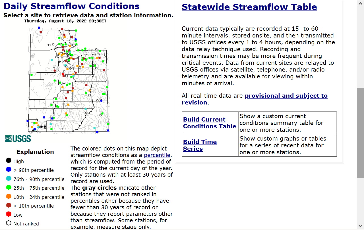 |
|
jamesp
Cave Dweller 
Member since October 2012
Posts: 36,555
|
Post by jamesp on Aug 19, 2022 17:09:54 GMT -5
I predict we will have weather for the rest of the week. jamesp is concerned about the drought out west. We have been having heavy rain showers all week. For him and all Utah members here is:
waterdata.usgs.gov/ut/nwis/rtStatewide Streamflow Table Current data typically are recorded at 15- to 60-minute intervals, stored onsite, and then transmitted to USGS offices every 1 to 4 hours, depending on the data relay technique used. Recording and transmission times may be more frequent during critical events. Data from current sites are relayed to USGS offices via satellite, telephone, and/or radio telemetry and are available for viewing within minutes of arrival. All real-time data are provisional and subject to revision. Build Current Conditions Table Show a custom current conditions summary table for one or more stations. Build Time Series Show custom graphs or tables for a series of recent data for one or more stations. That is a great site Dave. It has been around for a long time. It is the benchmark for river and stream flow. Good to hear the rains are coming your way. |
|
pizzano
Cave Dweller
Member since February 2018
Posts: 1,390
|
Post by pizzano on Aug 19, 2022 18:32:52 GMT -5
Yes Professor.........More Monsoons headed your way.
My son keeps me abreast of the Utah climate conditions all the time........before he moved there (Utah), he spent a lot of time studying those aspects since he spends 90% of his waking hours out of doors......due to profession and hobbies/recreation.
I understand it's not "abnormal" for monsoon conditions during Utah summers, but what you guys have been experiencing the last 4 or 5 years is somewhat historical.........Farmers Almanac history as far back as 1818, provides a very good representation of the decade cycles.........what you are experiencing now has only happened within two other (recorded) climate cycles......for much fewer lengths of time and greater precipitation amounts at one time.........now, it seems more events, longer durations but less amount wet at one time......more humidity.
I've personally experienced, on two occasions the last 3 years, snow, lots of it, at elevations like Snowbird, during late August and early September.....lasting 2 or 3 days, then poof, gone until late October and on.
It's the long periods of +95 to 105* that's reducing (at least the States north/central and northeast) water tables, due to rapid snow pack melt you guys rely heavily on......that's what my Son is most alarmed about...lot's of that run-off supports the Colorado River......and Southwest/Southeast California.
|
|
|
|
Post by 1dave on Aug 19, 2022 20:42:51 GMT -5
We just experienced "ROLLING THUNDER" for about 20 minutes on the mountain tops east of us!
|
|