jamesp
Cave Dweller 
Member since October 2012
Posts: 36,155
|
Post by jamesp on Sept 11, 2019 6:13:41 GMT -5
This is an article about the time frame of early man's occupation of the North American continent. It is based on evidence made from stone because stone was needed for survival in the form of spearheads and stone lasts for many ages. This particular stone was fashioned in most cases from forms of quartz gems such as chert/flint/agate/pet wood/etc. The end product being focused on in this writing is referred to as fluted spearhead points. Fluted spearheads are rare and found at the lowest layer in the ground repeatedly during thousands of archaeological digs from the east to west coast. Also found in these digs are wood fragments, human remains, stone tools and other items altered or collected by early man. The organic items found at the lowest layer where fluted points are found are subject to dating methods. The scientific community is running into a little conundrum in recent years. They are finding that man's artifacts are much more recent than originally believed. Dating methods ranging from the last ice age say 6000 to 13,000 years ago has become accurate because they can be compared to materials dated from historically recorded civilizations. The sample size of materials used for dating is large due to the thousands of archaeological digs across the northern continent. And they are concerned that man could have even survived the brutal conditions of the last ice age. They are also having more problems proving evolution since it takes 100,000's of years for mammals to evolve and the evidence bank for evolved forms of man is really small. I am not writing this to argue evolution/creation, just looking at evidence of man's past here on earth. My personal experience in collecting spear and arrowhead points has been over a period of about 40 years. I have found thousands of points and only about 3 of them were the elusive fluted points since man's population was small in this early paleo time period when fluted points were made. My sources for collecting has been lake shores, rivers, plowed fields and cleared land mostly in N Alabama, Georgia and north Florida where fluted points are relatively common. Why are these early fluted spearheads fluted ? I have no idea other than it makes it easier to haft the spearhead onto a stick of wood in a streamlined arrangement. I do know that it takes great skill to flute a piece of quartz fashioned into a spearpoint. Modern flint knappers can do it but they are few and far. And they usually use modern materials to assist. Now for some photos with explanations. This is a standard time chronology for point types. Fluted points are always at the bottom of the archeological dig. Lowest level. Repeatedly in digs from east to west. Referred to as the paleo level. 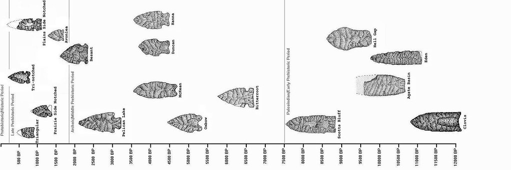 Photos/drawings of fluted points. The photo happens to be samples from Illinois. But this fluted design is found all over the northern continent.:  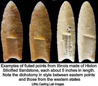 Population distribution of fluted points found mostly during archeological digs. The east has the higher density due to quality water sources like small springs. The red circles are my collecting grounds and these locations have an abundance of fine quality water sources and high densities of fluted point findings. 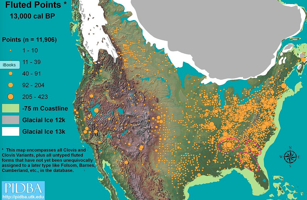 Compare to modern man's population density. Note for instance south Florida is densely populated by modern man but not so with early man. Because modern man ditched and dried out the everglades to make it habitable creating the Treasure coast, Naples, etc for instance. And central Florida was impenetrable without intervention of heavy equipment. You can dehydrate and die traversing 3 miles of Florida scrub, trust me. 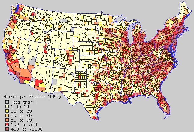 This is a typical archeological dig. Many universities perform these digs at native man encampments. By the thousands. They are all about the same, usually 2 to 4 feet in depth depending on silt and wind blown soils covering early man's encampments. I can look at map archives from various universities that have Archeology programs and find these early encampments. And do so I can go arrowhead hunting at these spots lol... 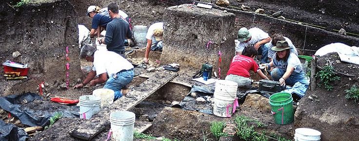 So the big question is when did man appear on this earth. If he appeared after or at the end of the last ice age there is some explaining to do. As a bare minimum man likely needed spearheads to survive. The fluted point is agreed upon as the the oldest point. Below that level there is little evidence of man. Fossil records are few and difficult to differentiate from primates. Stone artifacts are about as good as it gets as far as man made evidence goes. Well, many creationist will tell you that man has been here for 6000 years, the genealogy as listed in Genesis. One opinion. The often liberal minded scientific community has for the most part always opposed creation and favored evolution. Now the scientific community has perfected their dating methods and have begun to lay low on their evolution theories due to poor tangible evidence. They are starting to sweep their old beliefs under the rug. And that is the question I leave. Sort of an Investigation Discovery conundrum. Tangible evidence is not easy to disprove. This subject would not interest me had I not spent 1000's of hours in the field collecting points. If a bulldozer shaves off more than 2 to 3 feet of top soil man's artifacts are no longer existent. It is like this on so many sites I have frequented. It seems man's occupation here is quite recent. I have never studied fluted points existing in other continents. If they do and are found in the lowest layer of archeological digs then how did fluted technology spread over such a vast area ? |
|
|
|
Post by fernwood on Sept 11, 2019 7:19:28 GMT -5
Excellent article.
I have two fluted points that were found by my G-Grandfather. They were ID'd as a Clovis from Hixton Quartzite. Was told it was a rare find for NW WI.
One was a small spear, one an arrowhead.
I am fascinated by all aspects of archaeology and early cultures. They are a great source for learning how to adapt to what the land gives.
|
|
gemfeller
Cave Dweller
Member since June 2011
Posts: 3,775 
|
Post by gemfeller on Sept 11, 2019 12:54:08 GMT -5
There's newly-published evidence from a west-central Idaho dig that dates to about 16,000 years ago. I'll link the article when/if I find it again.
Many archaeologists now believe the North American ice sheet caused ancient explorers to sail down the coast to areas free from ice. At that time, before the Big Melt, ocean levels were some 300 feet lower than at present. Most evidence of their passage is now underwater.
The Columbia River system was one of the first ice-free passages to the interior of North America such explorers would have encountered. The Columbia connects to Idaho's Salmon River near which the new artifacts were found.
Fluted points are associated with the Clovis culture. Years ago some archaeologists decided they were the earliest such artifacts to be found in the U.S. so they quit digging when Clovis points were found. Several recent digs below the Clovis horizon have yielded much older evidence of human habitation at several locations in the U.S. So the search continues...
|
|
gemfeller
Cave Dweller
Member since June 2011
Posts: 3,775
|
Post by gemfeller on Sept 11, 2019 13:08:11 GMT -5
|
|
Deleted
Deleted Member
Member since January 1970
Posts: 0
|
Post by Deleted on Sept 11, 2019 13:38:42 GMT -5
Just as an add-on with something closer to my area... For those who have visited Glass Buttes in search of obsidian, as did Clovis people some 11+ thousand years ago, you may not have been aware that just down the road to the east was the earliest known site (thus far) for human settlement in North America. This is the Rimrock Draw Rockshelter, near Riley junction between Glass Buttes and Burns.   Found approximately 8"/20cm beneath an undisturbed layer of volcanic ash securely tied to an eruption of Mt. St. Helens dated to 15,800 years ago, was a stone tool. This would make the tool at least 15,800 years old, and likely centuries older than that. The worked carnelian agate piece had been transported from elsewhere (though the source has yet to be matched, there is no known carnelian near to that site). One edge had been worn down, with indications that it had been used for carving bone or wood. On the sharper, less worn edge, there were traces of protein that belong to an exinct bison species, leading to the possibility that the tool was used to butcher or scrape hides. Modified obsidian flakes and bison bones have subsequently been found in the same layer nearby. Dating by radiocarbon and similar techniques can here be supplemented by matching deposits erupted from well-documented volcanic activity. They're finding lots of new sites throughout this part of the country.  Excavation of this site continues, so further discoveries are anticipated. Other sites in the Oregon High Desert are also yielding very early evidence. |
|
|
|
Post by HankRocks on Sept 11, 2019 14:37:51 GMT -5
Found approximately 8"/20cm beneath an undisturbed layer of volcanic ash securely tied to an eruption of Mt. St. Helens dated to 15,800 years ago, was a stone tool. This would make the tool at least 15,800 years old, and likely centuries older than that.
This is one of the problems with dating tools and artifacts. Your references are not always fixed. It does not seem impossible that the artifact was deposited on top of the ash layer and worked it's way down. I am no geologist so my knowledge of ash deposits and their density is limited, however with rain and cold who knows if it could have moved. The other issue with finding artifacts is the actual origin is not a sure thing. I would suspect that ancient people did pick up tools left by previous groups they found and carried them elsewhere. If one finds numerous burials with the same tools then things become more fixed. One tool by itself is pretty thin evidence.
Does make for interesting discussions.
|
|
|
|
Post by mohs on Sept 11, 2019 16:57:46 GMT -5
Some real interesting thoughts indeed I’ll have to read it a couple times to comprehend altho Fluting a stone is an incredible thought/mechanical skill All I can say is those ancients knew their rock How long have they been at deep time? Considering our technology A long long time indeed Everything else that matters Not long enough and then there is the Solutrean Hypotheses  anyway I’m no hands on type of excavator all I can do is read & try to understand which is sketchy what to believe ? and with my poor reasoning skills ha I might as well have been born yesterday w/the amount of opinions/ info there is to uncover keep on digging eta because The Aztec’s really blow my mind Their ideas of cosmological era’s & methods of how to appease the angry divinities for the continuation of the universe human sacrifice ! uggghhh they just went for the heart with their perfectly bi-faced, fluted, honed, obsidian blades over and over and over ect… not sure the universe was that important to keep appeased Yet suppose I should be grateful otherwise poof nothing would be Yet I don’t want to view them as savages They were humans after all And in balance they were no more crueler then their more enlightened barbarians conquerors I mean… at least the (Aztecs) killings had a metaphysical angle.... |
|
Deleted
Deleted Member
Member since January 1970
Posts: 0
|
Post by Deleted on Sept 11, 2019 17:35:22 GMT -5
This is one of the problems with dating tools and artifacts. Your references are not always fixed. It does not seem impossible that the artifact was deposited on top of the ash layer and worked it's way down. It has become usual to take such things into account. There is always some other academic or grad student who'd like to make a splash by attempting to poke holes (pun intended) in an excavation report's conclusions and methodology - 'tis the way things work in science - so archaeologists try to account for as many factors as are known. Some personal observations: While on bare soil, some setting might occur during the first few years a heavy object was placed upon a layer of tephra-ash, that does not explain a small piece such as this being located below an undisturbed layer (if it settled, there would be some disturbance, and the heavy object would compact any ash below it), nor the considerable depth below the ash layer where it was found. You can see from the photos that the archaeological dig is employing careful modern excavation and documentation techniques; any disturbances in strata would be documented. Nor would this have been a sparsely unvegetated site during this period, meaning that the tephra layer would have quickly been stabilized by grasses and other vegetation. My own Mt. St. Helens experience is that light volcanics quickly settle into a compact layer in the soil. There have also been studies of this in volcanically active places such as Iceland. Larger, heavier items don't travel downward through those layers (freeze-thaw cycles tend to pop things up to the surface, rather than the opposite - at least around here). As I mentioned, there have been other correlated finds in the same layer. This allows multiple dating techniques to be used: isotopic dating methods (including radiometric dating of the volcanic deposits, radiocarbon dating of organic, obsidian hydration, thermoluminescence, etc. The obsidian flakes sealed below the St. Helens tephra-S layer are also not found in this area or what would have once been upstream. While there are obsidian deposits at Glass Buttes and near Burns, that doesn't explain that they are flaked or their presence at this site. There are other sites nearly as old as this one (and perhaps older are yet to be reported) so the age isn't that surprising. The video mentions the Paisley Cave excavations, which have yielded human coprolites that have calibrated radiocarbon dates of over 14,000 years before 2000 (YB2K). Excavations there also produced worked tools, wooden implements, hearths, cordage and threads, etc. Near Fort Rock, Oregon, excavation in caves sealed beneath the ash layer from the explosion that created Crater Lake (7500 YB2K) have yielded sandals, woven fabric and basketry dating more than 10,000 YB2K. Although 10,000 years ago is at the start of the Clovis period, the Clovis didn't just pop up from nowhere. Also, these cave environments preclude settling through tephra deposits. The age of first settlement of the Americas has been continually pushed back as more artifacts have come to light over the past century. |
|
jamesp
Cave Dweller
Member since October 2012
Posts: 36,155
|
Post by jamesp on Sept 12, 2019 4:24:03 GMT -5
I appreciate the interesting points made above. Let me discuss the simplicity of collecting stone artifacts here in the east on our mostly old stable clay soils.
Due to the high density of drinkable water sources Native encampments are so common here and for this reason there is not much respect for land disturbances on Native encampments.
Some notes on stone artifact collecting in the eastern US.
Here in the east the 'plow zone' is often referred to. This is the zone us artifact collectors pursue for stone artifacts.
This is normally about the top 24 to 30 inches of soil unless the plowed find is in a flood plain where silt deposits occur. Often a poor spot to collect.
Or on a slope where erosion has removed surface soil. Early man rarely chose slopes for encampments.
Most agricultural fields have little soil movement and are stable. Erosion is avoided, terracing and plowing perpendicular to slope for instance is common practice.
A hard undisturbed clay layer is often under the plow zone.
A lot of land has never been plowed and permanently vegetated with little soil shifting and deposits are organic in nature. These locations may be timbered every 3 to 4 decades.
Most eastern archeological digs are rather shallow. Most stone artifacts are found in the top 24 inches of stable land, with higher percentage found in the top 12 inches
Deeper excavations so common around eastern cities such as building sites where soils is removed deeper than 18 inches will rarely yield stone artifacts.
The artifact layer is easy to delineate because of the stain left by decaying organic matter. This observation made personally on thousands of acres over the years.
Easy to see the organic stain in road cuts, erosion ditches, excavation sites, eroded hill tops, etc. So reading the top soil layer is important and easy to do.
The time to hunt artifacts is after rain after the grading contractor removes the trees and stumps and preferably spreads the richer top soil with his equipment exposing the top 12 to 18 inches.
Spreading the top soil to make the site look half attractive and surface composting smaller roots and limbs. Or in developments they scrape the top soil into piles and re-spread it after the development is complete for a better medium to grow grass and plants in. But there is delays in piling the top soil because it takes time to process the trees and burn the stumps.
Timber operations often defoliate large land tracts in the plow zone.
Some timber companies remove all the trees and deep disc plow the entire tract to re-plant. These land tracts sit dormant and without further disturbance for years.
The rains expose artifacts for 2 to 3 years until weeds and scrub hide the exposed ground.
Due to the high density of springs and creeks small encampments are common. The sites are all the same, flat spots just above river's and creek's flood zone.
Flood plains were avoided for encampments for obvious reasons.
Most artifact hunters can look over a 100 to 1000 acre deforestation from a high spot and point to the encampments before trekking onto the property by studying the topography and creek location. A 100 acre tract usually averages 2 creeks on it and often yields 2 to 4 encampments if that gives an idea of their frequency. Average size 1/4 to 1/2 acre.
If a river has flood plains say 1/2 mile wide and has flat ridge terminations protruding into the floodplain close to the river it is about guaranteed to have a dense population of stone artifacts.
An infrequent flat bluff adjacent to a river is a dead ringer for serious artifact collecting. If the bluff is due to a chert or quartz out crop then the site is really a hot spot.
A river or creek may have numerous flat ridge terminations in a mile of length. Lithic resources often right in the creek or river.
Many encampments are visible in large plowed field from a high point. The soil is stained dark from carbon. Many a camp fire built on encampments...
A site that is 20 miles form the house is the location of a progressive small town called Peachtree City. Flat Creek flows about 8 miles thru the center of this town.
Flat Creek has excellent semi-flat topography for encampments and a fine rich sandy loam. Low clay content makes for a clear water in this creek.
Size of creek and it's many tributaries makes it a perfect canoe highway system. Lush large wetlands surround the creek for plant and animal habitat.
Many commercial and residential clearings have been graded over the past 30 years in this town along with a plethora of golf courses.
Golf courses are prime artifact collecting sites because they often flank unbuildable land close to water ways and deep grading is not required. The soil intensely prepped for grasses.
The encampment density is extreme and the sites were heavily populated for many ages. The lithic materials imported from a 300 mile radius. The point types diverse in materials and design.
They also removed trees for 100+ and 200+ acre lakes along Flat Creek. There is a major fork in Flat Creek at the 200 acre lake. Me and wife picked up over 200 points in one day at that fork after heavy rains shortly after the grading work was completed. A 2 acre peninsula in the 100 acre lake was left exposed for 2 years and we picked up about 150 points at this spot. However these 150 points were made from many different materials from far away. Designs were recent to Woodland to Archaic to Paleo. Easily the most diverse encampment probably ever found in Georgia. I reported the site to the town. They were not happy, last thing they wanted was archeological shutdowns of their thriving developments. I have proof of this site, the collection is Elmer Glued to a picture frame. I will post below.
Part of the reason for this post was to bring to light the stable soil conditions in the east and that so much land was exposed and converted to crop land in periods over the past 200 years.
I thought these soil conditions may be of interest as related to finding stone artifacts and the high density of encampments due to the amount of quality water sources.
The repeatability of archeological digs in stable soils an interesting factor.
The 30 acres I live on has 3 creeks, a bit unusual. There are 3 well defined encampments. Two less than 1/8 acre and one about a 1/16 of an acre.
All yielding a 2 gallon bucket full of stone tools and points/fragments. Several unpaired mortar and pestles.
|
|
jamesp
Cave Dweller
Member since October 2012
Posts: 36,155
|
Post by jamesp on Sept 12, 2019 4:44:12 GMT -5
Water drainage of Flat Creek at Peachtree City Georgia. An well-to-do community that had the power to manipulate creeks and wetlands over the past 4 decades. Perhaps 20% of the desirable Native encampment topography was manipulated and deforested by heavy grading equipment. Guessing about 50 encampments exposed totaling 30 to 40 acres added together ranging from 1/8 acre to 2 acres. Many were quite advanced in lithic acquisitions and point designs over many ages An exceptional early settlement and not one archeological dig. Marshland marked denoting creek paths. 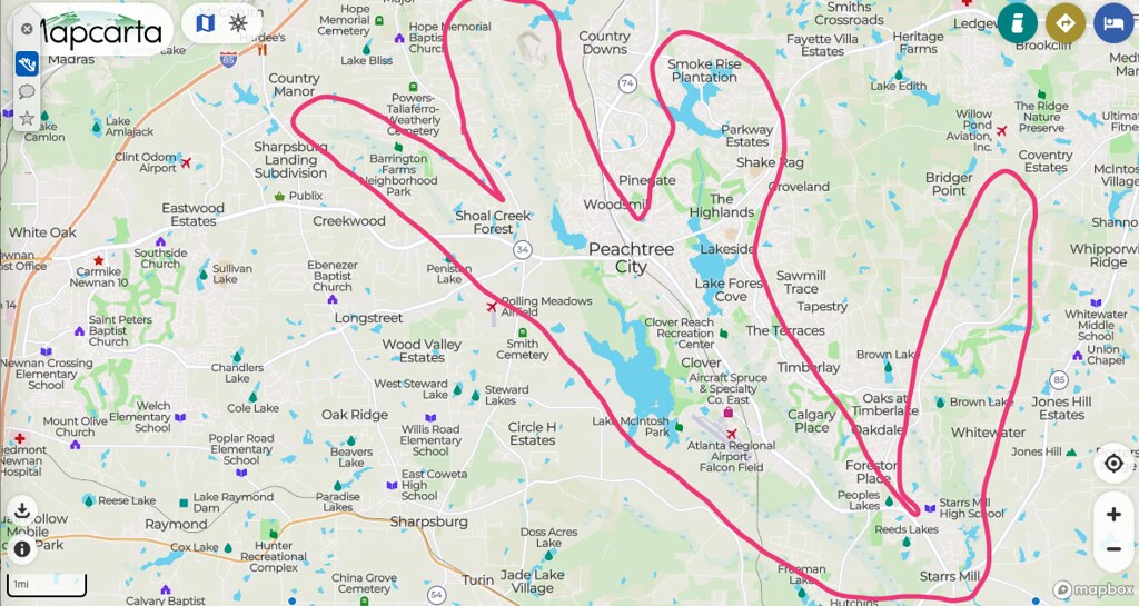 |
|
jamesp
Cave Dweller
Member since October 2012
Posts: 36,155
|
Post by jamesp on Sept 12, 2019 4:51:49 GMT -5
A link to a 3 hour collecting trip to a graded site along Flat Creek. Red clay is likely below the artifact zone, gray is in the artifact zone. Excellent example of soil coloring. The white quartz points are native to the site area. The flint chips are from a minimum 100 miles south east/west and 120 miles north west. www.flickr.com/photos/67205364@N06/albums/72157658341807963 |
|
jamesp
Cave Dweller
Member since October 2012
Posts: 36,155
|
Post by jamesp on Sept 12, 2019 4:55:38 GMT -5
A serious brew of materials and point designs from Macintosh Lake site. Aprox. 2 acres in size. Surface collected over a 2 year period. The better points not included on this frame. Not a single fluted point in over ~1500 points found at Peachtree City along Flat Creek and tributaries. The population of the early fluted point era was small so they are seriously rare. The lithic are simple - The white quartz is local, the black flint starts 120 miles northwest, the red and yellow cherts begin 100 miles south-south east-south west. Some of the tiny bird points at top are most recent. This would be the most largest variety of materials and point types I ever found in one site in 100's of encampments across the SE US. 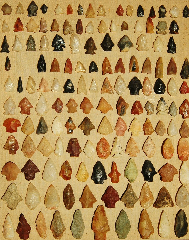 |
|
jamesp
Cave Dweller
Member since October 2012
Posts: 36,155
|
Post by jamesp on Sept 12, 2019 5:08:27 GMT -5
Probably the oldest, my wife found it on the Oconee River about 30 years ago. Never seen this material. I was very jealous; a serious mud fight ensued. 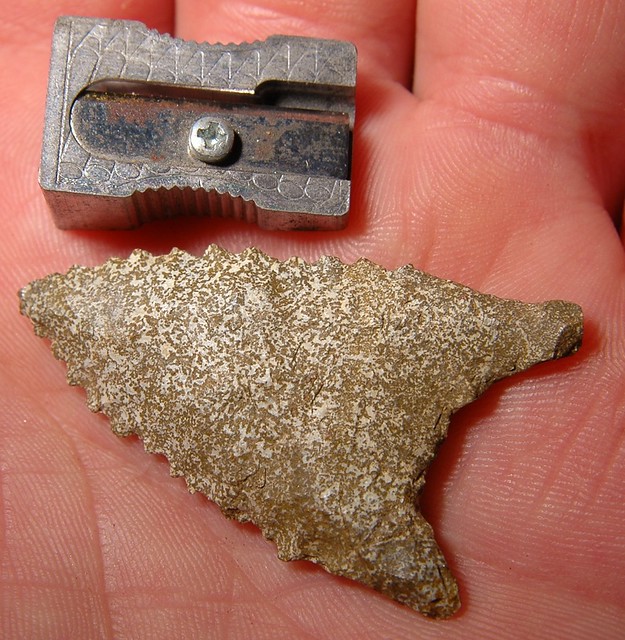 |
|
jamesp
Cave Dweller
Member since October 2012
Posts: 36,155
|
Post by jamesp on Sept 12, 2019 5:15:48 GMT -5
Central Florida points and tools. Silver River. The darker colored points at top left stained and polished by tannic acid river water and sand. Florida coastal chert and a few corals. Bland colors. Collecting in Florida is not easy due to shifting sand and it was simply less populated. Plenty of chert. Center tool just over 6 inches long. 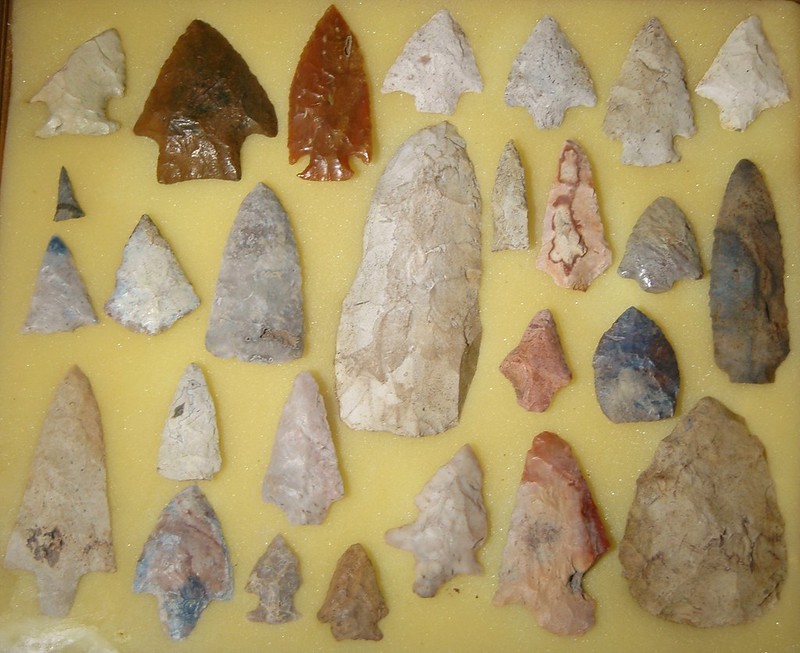 |
|
|
|
Post by fernwood on Sept 12, 2019 5:32:33 GMT -5
Sharing, as I trust the source, my Mom.
Part 1:
My G-Grandfather was plowing an area for the first time in the late 1800's. He was using a rather large, two bottom plow, drawn by a two horse team. I still have the plow he used. The blades go down about 2.5'. After plowing, he hooked a wagon up to one of the horses and began the process of rock removal.
As he was throwing rocks into the wagon, he would find other interesting items. Among those items were 5 points of various styles.
As a young child, I was fascinated with these points. They were kept in the center drawer of a Secretary bookcase in our living room. At times they were taken out for me to hold/look at, under close supervision.
At the time, there was pencil writing on two of them with the found date. Most of that writing is now worn off.
I have 4 of these points. Do not know what happened to the 5th one.
They were found in an area with a mix of clay/sand soil. Located next to a large chain of lakes. My childhood home.
I later researched the area and discovered that the largest harvesting rights battle in Wisconsin occurred on that site. At the same time, there was another battle going on near Mole Lake.
That one has some recorded history attached to it. The one in NW WI has no recorded History, other than being passed down by Anishinaabe Elders.
Here is part 2 of my sharing. This was told to me by an Anishinaabe Tribal Elder while he was at my place. I had previously shown him the points and asked him if he knew anything about them. He let me record our visit.
In 1806 there was a huge, well recorded war over harvesting rights between the Souix and my ancestors near Mole Lake. At the same time, a little known war was happening on this land. There were 4 tribes involved. My ancestors, Lakota Sioux, Menomonie and Dakota. It is estimated that over 10,000 fought this battle. The Souix and Dakota had journeyed long to try to get this land and surrounding areas. It was good land for harvesting.
An estimated 6000 died in battle. Right here. Right there. (He pointed to specific spots).
At the time my ancestors were on the land. They hunted, fished and gathered here. The Souix wanted their land back. The Menomonie wanted to expand their territory.
In the end, the Souix won. My people regained it, many years later.
Back to the points. My friend told me that those going into battle often used Sacred points. Ones handed down for generations. Those points carried the wisdom of the Ancestors. Some had been used in previous battles.
My friend later showed me some blood stained points he had. They were battle used, from his ancestors.
Our discussions and his site visits (we had many more) occurred in 2003 to 2005.
Going to throw something out there. When a site with archaeological significance is discovered, artifacts are often used to date the site. What if some of these artifacts were passed down for generations? What if there is a mix of old and relatively new artifacts?
How do archaeologists determine the actual dates of the site? By the most recent artifacts found?
Very curious.
|
|
|
|
Post by fernwood on Sept 12, 2019 5:34:08 GMT -5
jamesp We were typing at the same time. Yes, the plow zone is very important.
|
|
jamesp
Cave Dweller
Member since October 2012
Posts: 36,155
|
Post by jamesp on Sept 12, 2019 9:38:23 GMT -5
jamesp We were typing at the same time. Yes, the plow zone is very important. Interesting stories fernwood. To have had battles so recently is mind blowing. It is mind blowing to comprehend that a stone point was made by such early peoples. Without internet and modern media it is odd that the fluted point was so widespread across the Northern continent. Yet it is found in the lowest layer from east to west US with little variation. Makes one wonder how the fluted method was so widespread over such a large territory. Dating accuracy still seems to be bouncing around. There are a lot of issues with dating. Time has mysterious effects. The people that argue about accuracy are highly educated and difficult for a layman to interpret. It is aggravating to listen to a scientist say that a fossil is 33 million years old when he has absolutely no basis for claiming something is that old. These claims are frustrating at best. Even items 1000 years old still raise controversy when dating methods are applied to it. There is consistency in layered archeological digs and their age numbers seem more agreed upon. But ages are going to always create controversy. Judging from shallow stone artifact levels here in the east it seems they were left behind later than than earlier. |
|
Deleted
Deleted Member
Member since January 1970
Posts: 0
|
Post by Deleted on Sept 12, 2019 13:50:06 GMT -5
and then there is the Solutrean Hypotheses We can hope for more info, but whether we'll live to see a solution to that one, the gap between Solutrean and Clovis or any definitive chronology of the settlement of the Western Hemisphere seems a vexed question. One of the problems with most of these finds is that we have the cultural artifacts, but not associated, testable human remains (bones, coprolites) corresponding to those eras. I wants answers, and I wants em NOW. When a site with archaeological significance is discovered, artifacts are often used to date the site. What if some of these artifacts were passed down for generations? What if there is a mix of old and relatively new artifacts? How do archaeologists determine the actual dates of the site? By the most recent artifacts found? What an interesting story to be able to pass on about your land! Archaeologists excavate sites following the deposition layers, mm by mm, carefully documenting each layer and any finds in them as they go down. As James mentioned, the layers are marked by differences in soil color, texture and content (periods of vegetation cover, fire, human activity, flood and volcanic deposits, regular accumulation of windborne dust, etc.). They are always on the lookout for intrusive deposits (items that cut through the layers: pits, post holes and similar) and typically excavate several "squares" at the location at the same time to establish that the same sequence of layering is typical across the site and to help identify anomalies in the layering. You can think of the layers (strata) as being like rings in a tree. Aside from generally getting older the deeper one goes, the contents of the layers can be dated. In historic times, the artifacts themselves can be context-dated. As one approaches prehistoric eras, several other dating methods can be used. These include dating organic material (vegetation, charcoal, bones, etc.) by measuring the carbon and other isotopes they absorbed while still living, and several other methods (radiometric, mineral hydration, luminescence, etc.) that track the rates which things break down over time. Often multiple tests will be used to corroborate the dating when establishing baselines, and also when something unusual or potentially controversial finds are uncovered. For very ancient sites, geological dating methods (lithostratigraphy, magnetostratigraphy, tephrochronology, etc.) to augment other dating methods being used. These methods have been considerably refined over the last 75 years, and excavators are now extremely careful to avoid things like cross-contamination when collecting (something that wasn't always taken into account when these first were used - leading to many older finds having to be re-tested for verification). |
|
|
|
Post by fernwood on Sept 12, 2019 14:09:57 GMT -5
Interesting thing is that I have seen the land layers 4' down. That occurred when fence post holes were being dug. Also when soil samples were taken for a new septic system. All that was found then was sand and the most beautiful red/yellow clay I have ever seen.
Some of the battle land has been sold over the past 40 years. The rest will have a final sale in a couple of weeks. I am unable to return to the land before the sale is final.
A couple good friends have documented the battle site. Since the mineral rights to the property were sold in the early 1900's, I am hoping my friends come through if there are changes to allow for mining close to water.
If the land was to be mined, there would be many bones and other artifacts found there.
It is presently illegal to disturb sites with Native significance, but a lot depends on who you are and why you want to disturb the site. Am not going to get political here, but if anyone is interested they can investigate themselves. It is also illegal to allow mining activities that close to a waterway, but again....
|
|
jamesp
Cave Dweller
Member since October 2012
Posts: 36,155
|
Post by jamesp on Sept 13, 2019 5:50:23 GMT -5
There's newly-published evidence from a west-central Idaho dig that dates to about 16,000 years ago. I'll link the article when/if I find it again. Many archaeologists now believe the North American ice sheet caused ancient explorers to sail down the coast to areas free from ice. At that time, before the Big Melt, ocean levels were some 300 feet lower than at present. Most evidence of their passage is now underwater. The Columbia River system was one of the first ice-free passages to the interior of North America such explorers would have encountered. The Columbia connects to Idaho's Salmon River near which the new artifacts were found. Fluted points are associated with the Clovis culture. Years ago some archaeologists decided they were the earliest such artifacts to be found in the U.S. so they quit digging when Clovis points were found. Several recent digs below the Clovis horizon have yielded much older evidence of human habitation at several locations in the U.S. So the search continues... The arrival to the NW US from the Bering Straight as related to the fluted point is of great interest gemfeller. The ~16,000 year dating in the north west makes perfect sense as related to fluted points Mr. Rick. The most common oldest datum in eastern sites is ~11,000 to 12,000. Assuming the archeologists used the same dating technology east and west. Early man traveling across the Bearing Straight would likely put him in the western US first, give 4000 years for him to infiltrate across to the east coast bringing the fluted point with him. A few decades ago many archeologists believed in early numbers closer to 30,000 years instead of 11,000 to 16,000. Some new wave archeologists are leaning towards early numbers that are later, 6000 to 8000 years ago or even later. When the US was settled Columbus arrived 1492, by 1892 the western US had a fair population that arrived without the assistance of motorized vehicles. So 400 years is time enough for a large amount of people to settle the US east to west. Granted, not an apples for oranges comparison but a comparison to consider. Just saying, 1000 years is a long time. It is possible that the oldest fluted point is 4000 years old....it all depends on dating methods. The accuracy of dating methods continue to be an issue. The archeology community continues to argue dating methods. The creationists are not supposed to win the 6000 year theory; the scientific community has for the most part opposed their theories. It is interesting to sit back and observe this ongoing argument because there is a trend pointing towards the ages of creation theory of 6000 years being a real possibility. It is peculiar that the book of Genesis listed accurately the genealogy of man starting with Adam being close to 6000 years ago. This age would never be accepted by the scientific community due to the source. Easy to say since the Bible can be translated 100 different ways which is true. I personally have never been impressed with the missing link evidence that evolutionists hold on to so I lean towards lithic evidence. |
|