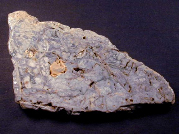
Firstly: capital, fossil, finds! Cha-ching!
Secondly:
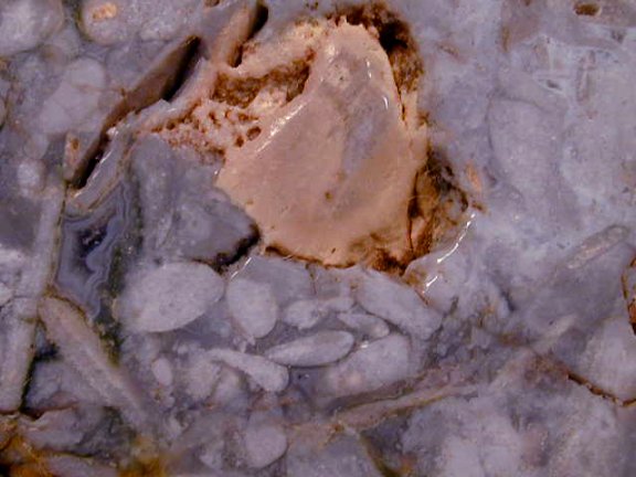
Well cripes: both of those are really spitting image of one another; I guess the only notable differences between them are the first one seems to lack these: (Mamelons) It very well could be a Stromatolite; funny enough it has the same silicified darkening that a large 2-3 lb one of mine has - it's nice to see the innards of one of those for a change


While the second one has them in high relief! I would say you're dead on in classing the second one as a stromatoporoid sponge! But it does look uncannily similar to two of my
Stromatolite dubbed finds near The Mad River: both in how they are colorized as well as in rock-form, and in the general laminated sinuosity stacking of the cell structures. The only difference from my two that resemble you're second one, is that they both seem to have been glaciated and are bereft of any sort of mamelons: leaving one of two possiblities: their either both Stromatolites, or sponges that lost they're mamelons (due to glaciation).
Additionally I thought I'd toss in some rare-form Stromatolite typus's, one from the Lower Ordovician in Buffalo County, Wisconsin that's agatized by Blue Agate:
(I thought I'd share this one too prove that Agatization of fossils did occur in places in the Ordovician period)


Next is another type of Stromatolite from Itasca County, Minnesota of the Proterozoic age, & perhaps 2 billion years old. I've also found a similar specimen to this one in Ohio; which might've truly been brought in by a Northern Glacier.
Heres the Itasca Co. MN specimen:
 As for The Teays (running theory)
:
To answer your question though, I do believe there were tectonic uplifts along the route of the Teays: one was proven to have occurred in OH along that route! This being from the PDF article below:
"For most of the past 245 million years, during the Mesozoic Era and the Tertiary Period of the Cenozoic Era, Ohio has been subjected to extensive uplift, erosion, and weathering. Within the past 2 million years, sediments of the Quaternary period were deposited. The Quaternary Period consists of the Pleistocene Epoch, commonly referred to as the Ice Age, and the Holocene Epoch also called the Recent."ohiodnr.gov/Portals/10/pdf/OH_SurfaceRocks_Sediments.pdfSince the Teays was pre-illinoian and ran before the Pleistocene Glacial disruption it would've had millions of years to have created Marine Sedimentary Agates in or around the Teays strata, maybe around the Ordovician or somewhere along the Paleozoic period; before the uplifts began in Ohio in the Mesozoic Era & from the Pliestocene (epoch) glaciers in the Cenozoic Era: in which the southward advances of the ice dams killed off the Teays. I would see if any uplifts began around the same time period in Illinois, if so that'd really be something? Why I ask this is because in the PDF above on page 5, the Illinois basin where the Teays used to run.. as well as in my part of Southwestern Ohio, they share the same surface rocks and sediments from
the Ordovician period. Also on page 8 of that PDF there is a write up on sedimentary facies can contain many marine organisms & I'd bet as to say, that they might also contain permeation of cryptocrystalline material in the skeletal structures of some of those matrix locked fossils. Also figure 5.6 on page 8 shows something called paraconformity, it involves an overlying Sirulian limestone on top of Ordovician period Shale.
With the Teays being found in Ordovician period rock (the pink highlights in this picture): It makes sense why there would be Ordovician rock exposed near to Cincinnati Ohio because the Teays used to run through that area; as for the area around Dayton the PDF above says that Sirulian rocks are at the surface, overlying Ordovican strata, this is exactly how the Teays is found in the picture below; and since Ordovician is exposed along it's route near Cincinnati it proves the Teays was uplifted! Also since all of my specimens were found in areas along it's former route, in the very areas that were swafted out by the Teays! There's no doubt in my mind that the specimens were probably from the uplifts and carried to those sites at a later period than the
original uplifts in the Mesozoic Era: by the Pliestocenes that moved in around 1.5- 2 mya ago & receded to form the current Mad River, Little Miami and small tributaries I've hunted. So it has to have been uplifted elsewhere in the other states it used to course through as well!

I don't know the exact time in which the Teays formed, but I do believe it would've had to have been altered in the Mesozoic Era by the uplift/uplifts that occurred then and this probably fleshed out a larger path for The Teays to travel (hence what you said: "
the teays followed the rifts of those uplifts") given the industriousness of water. Then the Pliestocenes came in and caused more uplifts through glaciation and subordinated the Teays beneath it, forming the rivers/tributaries found now in Ohio by Pliestocene melt-waters. This very surge of new waters traveling some of the old Teays route had to have culled up left over strata from the Teays; and caused deposition of the refugee materials in and around the new bodies of water - hence found as surface material that can be cherry picked as so, or buried in mud only said-# of feet down. Who knows (if this theory is even somewhat right) the material I find along the old Teays route could have come from pockets in between the Sirulian Limestone & Ordovician shale; many of my specimens look to have been bedded in a hodgepodge like material as so. But others are too water worn and matrix-freed to tell.
Just my two sense on how your or my agates may have been formed though ;D & yes people say the Teays is still down there, very much mobile; some people even think there might be a spillway of small caves it travels through or sink holes like in Tennessee.
Ps. I did find information on an uplift in Illinois in the Matthiessen State Park, which seems to be near to the alignment of the Teays route and has Ordovician period rocks: namely Dolomite/Dolostone & Sandstone. Here is a excerpt from article: (With the bolded parts of the article of import)
Geology of Matthiessen State Park
geologyonline.museum.state.il.us/tools/fieldtrips/trip3/index.htmlThe many unique and beautiful rock formations exposed in the Upper and Lower Dell areas of the canyon are composed primarily of St. Peter Sandstone. The Upper Dell begins at Deer Park Lake and continues to Cascade Falls, where the canyon descends 45 feet to the Lower Dell. In total, the canyon is about 1 mile long from Deer Park Lake to the Vermilion River. Closer to the Vermilion River, where the
Platteville Limestone overlying the St. Peter Sandstone is visible, the rocks are folded, and the strata dip steeply toward the river along the west flank of the La Salle Anticlinorium.At the park and nearby areas, the
Platteville Dolomite (Ordovician) rests directly on the St. Peter Sandstone (Ordovician). The interval marked by the erosion surface on the top of the St. Peter Sandstone represents one of several
unconformities present in the Paleozoic succession.
Pennsylvanian strata are also well exposed along the Vermilion River in the park. That these rock layers dip (tilt) less steeply than the Platteville and St. Peter Formations indicates that the older Ordovician rocks were tilted both
during one of the episodes of uplift along the La Salle Anticlinorium before the Pennsylvanian strata were deposited and again when the Pennsylvanian strata were folded. In this area, the
unconformity between the Pennsylvanian and Ordovician rocks, marked by the significant difference in their dips, is known as an angular unconformity.
Platteville DolomiteThe Platteville Dolomite is classified as a group by geologists and consists of five formations, many of which are recognized by only slight differences in subsurface samples. Because the units of the group are difficult to distinguish in surface exposures, we will discuss the Platteville as one rock unit. The Platteville Dolomite underlies all of the region except for a small area in the north-central part. It also occurs in small outliers west and southwest of Ottawa that represent remnants left behind when the surrounding rocks were eroded away.
The Platteville Dolomite consists of brown, buff, and gray, finely crystalline, compact dolomite and fossiliferous brown and gray, finely granular (or lithographic) dolomitic limestone that has a distinctive mottled appearance. At several horizons,
lenses and nodules of chert are common. The Platteville is 125 to 140 feet thick in the vicinity of Marseilles, but in the immediate area, east of the La Salle Anticlinorium, thicknesses of more than 100 feet are attained only locally.
Here is an interesting pull from Roger Clarks Fairburn Agate 3rd ed on Chert Nodules and Diagenesis to Agate:
Compaction laminae are typically draped around chert nodules, indicating silicification prior to compaction. Isolated dolomite rhombs within cherts are common, and these are normally interpreted to indicate that preferential silicification of calcite and aragonite occured after inception of dolomitization but before it could proceed beyond formation of isolated crystals. In short, virtually every study of nodular chert formation has included evidence that the nodules were formed during early diagenesis and before compaction. Knauth, Petrogenesis of Chert (1994), p. 245
This is a process that is known to create Sedimentary Agates.
Additionally: (from Roger Clarks Fairburn Agate 3rd ed)
Silicification is a common diagenetic phenomenon in a wide variety of originally non-siliceous sediments. Examples of partial to minor silicification include: (1) Silicification of fossil wood; (2) Chertification of Carbonates (namely dolomite or marine fossils) and carbonate-bearing sand stones; and (3) replacement of evaporites. Hesse, "Silica Diagenesis" (1990), p. 253
Silicification and Diagenesis can lead to Agatization! Seems like Agate Creation would be a strong possibility given the geology of the areas where the former Teays River existed.