|
|
Post by rockpickerforever on Oct 6, 2013 13:06:00 GMT -5
I had heard about Tropical Storm (now tropical depression) Karen. Had wondered if it would change your plans.
We have had a couple tropical storms/depressions through here that I remember (in the 70s, 80s). When one storm can double the yearly amount of rainfall you get, it causes big problems. One of those storms took out the westbound lanes of I-8, going down Mtn Springs grade into the desert. The flash flood also took out the railroad tracks at the bottom of the slope. Took at least a year for the damaged part of the highway to be fixed. I think the tracks were just abandoned, never repaired or used again.
Crossing my fingers for you that Karen doesn't dump on your hunting grounds!
|
|
jamesp
Cave Dweller 
Member since October 2012
Posts: 36,602
|
Post by jamesp on Oct 6, 2013 13:12:45 GMT -5
I was involved in supplying plants for a miniature treatment plant that fit on a residential lot for you south Florida folks living on coral.
It was just a pond with plants to pretreat septic solution. Astor Florida just inland from Daytona was built on dug canal soil and very low.
They installed new system that pumps sewage to treatment plant(using macerator pumps for each resident). EXPENSIVE and Astor residents got the bill.
Bet that is what they have done to you. That ocean water passing by is full of the rest of the worlds crap and nuc radiation while they have all our jobs.
|
|
|
|
Post by pghram on Oct 9, 2013 13:50:03 GMT -5
Great thread, thanks to all for the education.
Rich
|
|
patrock
off to a rocking start

Member since August 2015
Posts: 23 
|
Post by patrock on Aug 15, 2015 17:01:10 GMT -5
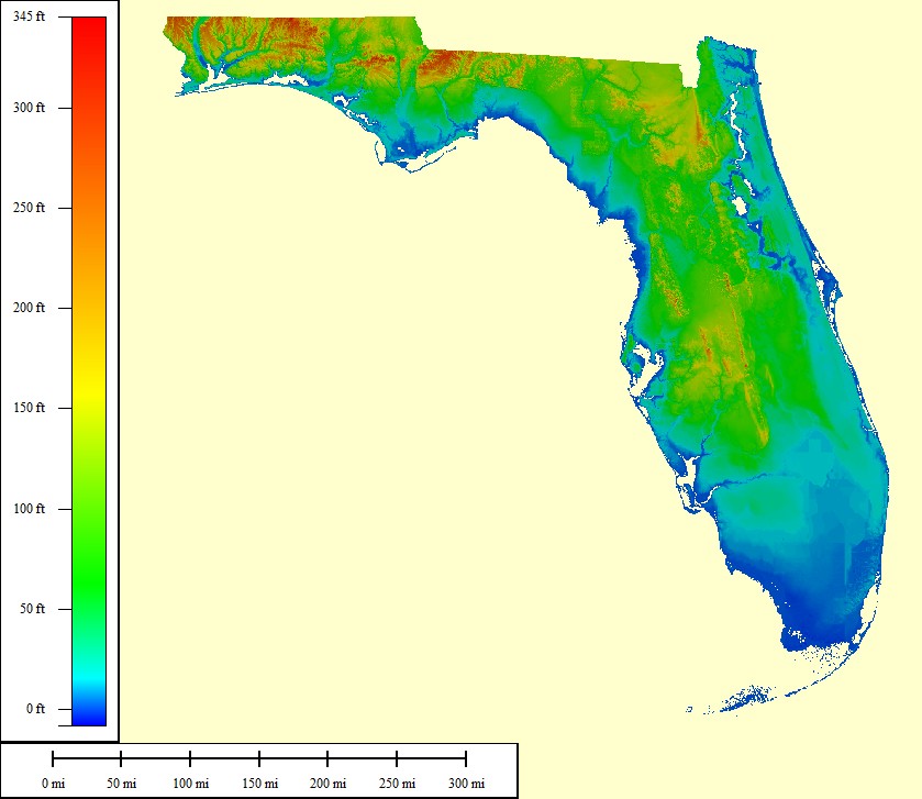
Amazing. The yellow is where it is. The reds is to high and the greens are too deep. The broad plateaus in the northern section and central section of the peninsula. The panhandle (to the left) was probably to steep and had too much wave action. So yellow at 160 to orange at 200 in the broad flat areas. Zero- 40 feet is the best depth for coral. Shallow probably warmer and better for light penetration. Those large areas are covered with sand and to find coral there must be an excavation or a river exposing it. The northern area extends into Georgia about 20 miles and has a wide variety of color and a high percentage of glass like silicifications in large pieces. Death plate and fossilized algae layers also very well silicified. The southern plateau is a very different silicification in terms of color and often an orientation of fracture as if layered a bit, but often totally homogenous. The higher areas in the yellow zone are particularly productive. Probably closest to the surface and getting the most intense sun creating very large corals.  jamesp, I am trying to figure this board out and I posted a blank response then another and inadvertently deleted both. I live in Tallahassee and there is little to tumble. I am fairly new to the hobby and am thinking of taking my two boys on an expedition to the area you are talking about. Is this in the Live Oak area? The map is amazing when you think of coverage of water. Panamark's post is interesting as well. We have some native pieces of petrified wood from close to here that we partially crushed for tumbling. We found what appeared to be small streaks of wood fibers deep inside. |
|
jamesp
Cave Dweller 
Member since October 2012
Posts: 36,602
|
Post by jamesp on Aug 15, 2015 20:41:24 GMT -5
Welcome to the forum patrock. You have several spots. The Flint River around Albany. the Ecinofina River for coral. The Withlacoochee River near Clyattville. This book may help. There is another paperback about rocks in Florida.  |
|
patrock
off to a rocking start

Member since August 2015
Posts: 23 
|
Post by patrock on Aug 16, 2015 15:32:56 GMT -5
Thanks Jamesp,
I will definitely look for the book. We have been fishing in the mouth of the Aucilla for years. My brother was visiting and we found tons of flint and partial pieces of artifacts and some really great pottery shards there. All of the rock seems to be non-siliconized. I had given up hope for finding nice stuff in Florida.
|
|
jamesp
Cave Dweller 
Member since October 2012
Posts: 36,602
|
Post by jamesp on Aug 16, 2015 16:40:17 GMT -5
|
|
patrock
off to a rocking start

Member since August 2015
Posts: 23 
|
Post by patrock on Aug 17, 2015 19:45:23 GMT -5
Thanks jamesp,
Those folks are right here in town and they are listing some great places to hunt.
|
|
jamesp
Cave Dweller 
Member since October 2012
Posts: 36,602
|
Post by jamesp on Aug 18, 2015 7:58:55 GMT -5
Thanks jamesp, Those folks are right here in town and they are listing some great places to hunt. There is a lot of cool stuff in the Flint River. Fossils and chert, I have been there long ago and was mesmerized. It was a long time ago, it was either Bainbridge or Albany where miles of shoals cut through tons of fine cherts. |
|
jamesp
Cave Dweller 
Member since October 2012
Posts: 36,602
|
Post by jamesp on Aug 18, 2015 9:36:05 GMT -5
Thanks Jamesp, I will definitely look for the book. We have been fishing in the mouth of the Aucilla for years. My brother was visiting and we found tons of flint and partial pieces of artifacts and some really great pottery shards there. All of the rock seems to be non-siliconized. I had given up hope for finding nice stuff in Florida. This one has a section on Florida. But the best one is a small paperback about Florida. Trying to find it.  |
|
Deleted
Deleted Member
Member since January 1970
Posts: 0
|
Post by Deleted on Aug 18, 2015 14:30:47 GMT -5
Amazing. The yellow is where it is. The reds is to high and the greens are too deep. The broad plateaus in the northern section and central section of the peninsula. The panhandle (to the left) was probably to steep and had too much wave action. So yellow at 160 to orange at 200 in the broad flat areas. Zero- 40 feet is the best depth for coral. Shallow probably warmer and better for light penetration. Those large areas are covered with sand and to find coral there must be an excavation or a river exposing it. The northern area extends into Georgia about 20 miles and has a wide variety of color and a high percentage of glass like silicifications in large pieces. Death plate and fossilized algae layers also very well silicified. The southern plateau is a very different silicification in terms of color and often an orientation of fracture as if layered a bit, but often totally homogenous. The higher areas in the yellow zone are particularly productive. Probably closest to the surface and getting the most intense sun creating very large corals.  @captnbob |
|
jamesp
Cave Dweller 
Member since October 2012
Posts: 36,602
|
Post by jamesp on Aug 18, 2015 20:10:22 GMT -5
panamark's map from early in this thread shows a point from S. Georgia into Florida. That little nip is loaded with coral. It is a large deposit of eroded worn down Appalachian Mountains (clay). The Withlacoochee traverses thru that nip. We used to have Rocky Mountains too, but they are old and worn down. And washed south toward Florida.
|
|


