pizzano
Cave Dweller 
Member since February 2018
Posts: 1,390
|
Post by pizzano on Aug 11, 2020 15:10:53 GMT -5
I have been practicing with a Walmart drone. Got a Mavic Mini unopened in box. Can't wait to graduate to flying it. Stunned at the control systems incorporated for controlling the motors on these things. Miracles of engineering. Taking dc motor controls to new levels for sure. DC motors are pretty amazing from the controllability stand point pizzano . This motor is not a over-the-top expensive motor like the military or industrial applications call for but it has gobs of torque and is smooth as silk. For tumblers there are plenty of fractional HP surplus motors the military paid $1000's of dollars to have made for under $20 surplus. And adjustable surplus power supplies with serious control features can be had for cheap. It is hard to stop this motor by squeezing with fingers at only 10 volts and many times more torque at 20 volts. It draws 1 amp when pinched as hard as I can physically squeeze. Normally enough to run a 12 pound rotary at 40 rpm. The Lot-O should draw way less. I was shocked to find one to fit the Lot-O with the needed dual output shafts. If the heat you mention is a problem it will be upsetting. Actually am very pumped to take a Lot-O into higher vibration rates. Or any vibe for that matter but the Lot-O is about a cool a vibe as there is. Sounds like the motor you have runs on a little different platform.......could work ok for your application. My familiarity with DC motors only exists in the model train and RC plane/drone environment............the amp load heat transfer issues changed a lot due to the cost effectiveness of brushless motors vs brushed. Initially, brushless was very expensive and due to the fact they required ESC components that differed from brush, raised that cost even more. But they are much more efficient and run much cooler at higher RPM's. In some cases, where, regardless of the rpm, brushed motors had to be run at higher rpm just to keep cool, brushless has no such barrier...........and their life span, even over tasked, is much longer. Well worth the cost association (they are now even less expensive than what a good brushed motor was 10yrs. ago).......Like the idea of higher vibe rates...!
Your Mavic Mini is a good trainer.....cheap and they are pretty tough.......it will teach you visual and physical orientation. A required skill one must master to really appreciate the technology. Keep things in "basic" mode initially, over time (it may happen quickly) you will find out whether or not you have the necessary "eye & hand" coordination and reaction response time needed to spend more time in the air, rather than "picking-up pieces" and repair. We all, at some point in time in our RC adventure, either become good pilots or better mechanics.........lol.......Have fun...!
|
|
jamesp
Cave Dweller
Member since October 2012
Posts: 36,155
|
Post by jamesp on Aug 12, 2020 1:39:18 GMT -5
You seem quite knowledgeable of the drone design. Are you into racing or photography or just flying ? They are addictive. I found a partial case of 8 tiny Propel brand drones in a salvage store cheap a year ago. Got them home, charged and ran the $20 drone and was stunned at the performance. Flew in the great room for the most part. Went down to Walmart and picked up a larger $100 unit that would go 500 feet high and like 1500' range to practice with. End use would be photography. This tumbler app is the most basic use of a DC motor pizzano. For each 6 volts you get 1450 rpm. 12 volts is 2900rpm, double it to 24 volts and the rpm doubles to 5800rpm. Using a simple 0 to 30 volt adjustable bench type power supply. The motor voltage and current was highly linear according to power supply. May just use the bench power supply to optimize tumbling rpm and switch to a little fixed voltage industrial supply for production and power efficiency. Further research, these dual shaft motors appear to be used somewhere in copying machines. So duty rating is a concern. They have a large rpm range from 2000 to 15,000rpm. Run off 6 to 24 volts for variable rpm. Many are brushless, most have ball bearings. Most under $10. This one on the large side with 6mm diameter shafts but the smaller units with 4mm shafts may handle counterweights and supply plenty of vibrational force for a Lot-O due to the high speeds. Minimal counterweights can deliver substantial vibration forces at high rpm. |
|
EricD
Cave Dweller
High in the Mountains
Member since November 2019
Posts: 1,142
|
Post by EricD on Aug 12, 2020 8:47:32 GMT -5
I was thinking last night about mounting a shaft and increasing the RPM of my lot-o counterweights with pulleys/belt.
I might tinker with that some day. Or get another lot-o to experiment with so I still have a vibe running.
Having an AC motor with it's own cooling is just too convenient.
|
|
|
|
Post by knave on Aug 12, 2020 9:43:15 GMT -5
I was thinking last night about mounting a shaft and increasing the RPM of my lot-o counterweights with pulleys/belt. I might tinker with that some day. Or get another lot-o to experiment with so I still have a vibe running. Having an AC motor with it's own cooling is just too convenient. I want to make 120hz that would make the LOTO purr. |
|
pizzano
Cave Dweller
Member since February 2018
Posts: 1,390
|
Post by pizzano on Aug 12, 2020 10:56:33 GMT -5
You seem quite knowledgeable of the drone design. Are you into racing or photography or just flying ? They are addictive. I found a partial case of 8 tiny Propel brand drones in a salvage store cheap a year ago. Got them home, charged and ran the $20 drone and was stunned at the performance. Flew in the great room for the most part. Went down to Walmart and picked up a larger $100 unit that would go 500 feet high and like 1500' range to practice with. End use would be photography. This tumbler app is the most basic use of a DC motor pizzano . For each 6 volts you get 1450 rpm. 12 volts is 2900rpm, double it to 24 volts and the rpm doubles to 5800rpm. Using a simple 0 to 30 volt adjustable bench type power supply. The motor voltage and current was highly linear according to power supply. May just use the bench power supply to optimize tumbling rpm and switch to a little fixed voltage industrial supply for production and power efficiency. Further research, these dual shaft motors appear to be used somewhere in copying machines. So duty rating is a concern. They have a large rpm range from 2000 to 15,000rpm. Run off 6 to 24 volts for variable rpm. Many are brushless, most have ball bearings. Most under $10. This one on the large side with 6mm diameter shafts but the smaller units with 4mm shafts may handle counterweights and supply plenty of vibrational force for a Lot-O due to the high speeds. Minimal counterweights can deliver substantial vibration forces at high rpm. jamesp............It's a little off topic, but this link will answer a few "drone" questions........I've been at it quite some time.......:
If you have any specific questions, feel free to PM me.........I'm a little out dated on "hobby" type craft, but all of the foundation principles that applied yrs. back still apply today....!
|
|
jamesp
Cave Dweller
Member since October 2012
Posts: 36,155
|
Post by jamesp on Aug 13, 2020 8:44:28 GMT -5
It's all amazing pizzano. The drone thing would be so helpful for rock hunting. I did have the fortuhnicity of Google Earth satellite images via the cell phone to find rock covered bald spots located in the mesquite and cactus shrub lands of south Texas for hiking to. But not all locations had the cell signal. The drone would have solved that problem. The difficult to access open patches of ground were the agate and wood gold mines. Just wear thorn protective clothing to do the short hike ! The same game with other types of vegetative cover in this part of the country like timbered clear cuts and construction activity where ground exposures occur but not yet shown on Google Earth. |
|
pizzano
Cave Dweller
Member since February 2018
Posts: 1,390
|
Post by pizzano on Aug 13, 2020 11:17:15 GMT -5
Yes......UAV has come a long way very fast and the technology is still growing. With Thermal Imaging and LiDar applications , the use of UAV has become the standard in the industry for almost anything related to geological aerial photography. Just add flight plan logistic software, GIS interface and CADD transfer applications.......and away we go.....lol
The link I attached previously includes an additional post with several helpful links related to UAV...........take a look at those for current tech info.
One of the drawbacks to the rock hounding UAV aspect is packing the equipment around and not damaging anything vital........as if we don't haul around enough already. Unless one has initially planned (mapped) out a region for discovery, rather than just going on a hounding hike and throwing up a "drone" for observation every few miles and at most 15min's at a time (depending how many fully charged batteries you bring along)..........and that is if one has mastered the flight and photography aspects to accomplish this without wasting time and re-shooting due to several possible factors. It can be a little frustrating, but fun if not taken to seriously.
Mastering the craft flight and photography aspects prior to actual scouting is the key to making the "drone" application for hounding more enjoyable........I can't personally remember the number of times I took out a quad with the purpose of scouting a location for hounding, to only find, after reviewing the video and hiking to the location, a dozen different obstacles to deal with that were not obvious in the vid..........even with my trained eye's........lol
Anyway, enough about UAV.......back to the topic.....!
|
|
EricD
Cave Dweller
High in the Mountains
Member since November 2019
Posts: 1,142
|
Post by EricD on Aug 13, 2020 19:55:56 GMT -5
Yes......UAV has come a long way very fast and the technology is still growing. With Thermal Imaging and LiDar applications , the use of UAV has become the standard in the industry for almost anything related to geological aerial photography. Just add flight plan logistic software, GIS interface and CADD transfer applications.......and away we go.....lol
The link I attached previously includes an additional post with several helpful links related to UAV...........take a look at those for current tech info.
One of the drawbacks to the rock hounding UAV aspect is packing the equipment around and not damaging anything vital........as if we don't haul around enough already. Unless one has initially planned (mapped) out a region for discovery, rather than just going on a hounding hike and throwing up a "drone" for observation every few miles and at most 15min's at a time (depending how many fully charged batteries you bring along)..........and that is if one has mastered the flight and photography aspects to accomplish this without wasting time and re-shooting due to several possible factors. It can be a little frustrating, but fun if not taken to seriously.
Mastering the craft flight and photography aspects prior to actual scouting is the key to making the "drone" application for hounding more enjoyable........I can't personally remember the number of times I took out a quad with the purpose of scouting a location for hounding, to only find, after reviewing the video and hiking to the location, a dozen different obstacles to deal with that were not obvious in the vid..........even with my trained eye's........lol
Anyway, enough about UAV.......back to the topic.....!
I like this. You have a ton of knowledge on the subject. This could make a great topic in another thread if you don't want to continue it here! |
|
jamesp
Cave Dweller
Member since October 2012
Posts: 36,155
|
Post by jamesp on Aug 14, 2020 4:40:07 GMT -5
pizzano - This GE map is set at 2014 when I was here in south Texas one trip. The cell phone did not work in many locations here. Most of the roads shown are unusable since most are overgrown with tire puncturing cactus and shrubs. The whiter areas are collectable exposures where no foliage exists. The red line is high water mark for Lake Falcon. The blue line is a scaler at .3 miles. So the white areas are not visible from the usable roads due to foliage. For example - the white area at the upper left along the red line is where prevailing N.E. winds slam the waves into the lake shore and destroyed all foliage and exposed much rock. That spot is a petrified forest loaded with exotic woods and palms. Filling a 5 gallon bucket every 30 minutes with fine woods and palms. A gold mine. But many of the other exposures are devoid of rock and a drone would easily let you know this from 40 feet elevation. Google earth does not have good enough resolution to see the rock content at the exposures.  Ground view of lake shore at upper left of GE image:  10 minutes in a 30 foot circle. Moss agates on top row, woods/palms middle row, jaspers on lower row  above batch windowed 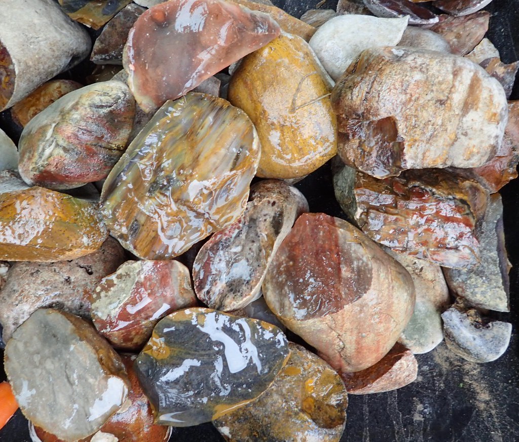    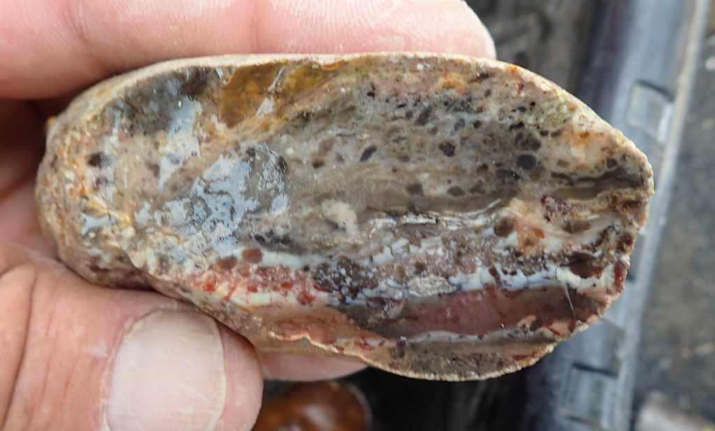 This was the dominate wood at this spot. dead solid and rarely a fracture  The last half of this flickr album was found at this shore line exposure, some of the best. Probably due to the fact it was closest to the Rio river shore. River was less than a mile from upper left hand corner of above map headed north westerly. www.flickr.com/photos/67205364@N06/sets/72157698981277390Always hit the NW facing shore lines of Lake Falcon.(maybe nobody knows that)
|
|
pizzano
Cave Dweller
Member since February 2018
Posts: 1,390
|
Post by pizzano on Aug 14, 2020 10:31:51 GMT -5
Depending on the terrain, type of handheld communication device and clear line of sight, there are many options available to scout terrain and map location guide tracking. I tend to require current and live applications. Therefore, I subscribe to two commercial applications ArcGis Terrain (Earth Pro version) and NASA World View. Both will work on a very good Cell Phone, but I travel with a lap-top. Google Earth Pro is convenient for the phone, but not always current and difficult to manage and record data history (coordinates) unless used on a lap-top..........it's part of what I do when working raw field contracts ...!
If invested, properly trained and experience driven, any number of these type of applications (to include UAV) are useful tools for ground tracking (scouting). It really depends on one's priorities. Since I do this (part-time now) for a living, applying the technology to my rock hounding excursions makes/made perfect sense. No steep learning curves or additional investments were/are needed.............not so much for the layman. It's like anything else related to hobby adventures. One either discovers they have an aptitude and are willing to spend the money and time taking advantage of the technology, digging deeper into the void, or they just dabble around the environment, just scratching the surface for floaters..........!
|
|
pizzano
Cave Dweller
Member since February 2018
Posts: 1,390
|
Post by pizzano on Aug 14, 2020 10:53:27 GMT -5
Yes......UAV has come a long way very fast and the technology is still growing. With Thermal Imaging and LiDar applications , the use of UAV has become the standard in the industry for almost anything related to geological aerial photography. Just add flight plan logistic software, GIS interface and CADD transfer applications.......and away we go.....lol
The link I attached previously includes an additional post with several helpful links related to UAV...........take a look at those for current tech info.
One of the drawbacks to the rock hounding UAV aspect is packing the equipment around and not damaging anything vital........as if we don't haul around enough already. Unless one has initially planned (mapped) out a region for discovery, rather than just going on a hounding hike and throwing up a "drone" for observation every few miles and at most 15min's at a time (depending how many fully charged batteries you bring along)..........and that is if one has mastered the flight and photography aspects to accomplish this without wasting time and re-shooting due to several possible factors. It can be a little frustrating, but fun if not taken to seriously.
Mastering the craft flight and photography aspects prior to actual scouting is the key to making the "drone" application for hounding more enjoyable........I can't personally remember the number of times I took out a quad with the purpose of scouting a location for hounding, to only find, after reviewing the video and hiking to the location, a dozen different obstacles to deal with that were not obvious in the vid..........even with my trained eye's........lol
Anyway, enough about UAV.......back to the topic.....!
I like this. You have a ton of knowledge on the subject. This could make a great topic in another thread if you don't want to continue it here! Ya, I figured a few here might...........lol
Not so long ago, I and few buddies, ran/owned a website forum dedicated to only UAV.........we sold it to RCGroups.com.....It became to much for us to manage since none of us were full-time into it and it was taking full-time attention...!..........we made a profit, but nothing worth retiring on........lol
Anyway, the links I provided previously are a good start for anyone interested in such. The subject matter can be/is very complex. I tend not to take the casual approach to it's complexity. Therefore, If anyone here is seriously considering getting into UAV and would like a few helpful tips in order to cut through the chase, they are more than welcome to PM me......but don't expect any pussy-footing around........lol
|
|
|
|
Post by HankRocks on Aug 14, 2020 12:34:13 GMT -5
pizzano - This GE map is set at 2014 when I was here in south Texas one trip. The cell phone did not work in many locations here. Most of the roads shown are unusable since most are overgrown with tire puncturing cactus and shrubs. The whiter areas are collectable exposures where no foliage exists. The red line is high water mark for Lake Falcon. The blue line is a scaler at .3 miles. So the white areas are not visible from the usable roads due to foliage. For example - the white area at the upper left along the red line is where prevailing N.E. winds slam the waves into the lake shore and destroyed all foliage and exposed much rock. That spot is a petrified forest loaded with exotic woods and palms. Filling a 5 gallon bucket every 30 minutes with fine woods and palms. A gold mine. But many of the other exposures are devoid of rock and a drone would easily let you know this from 40 feet elevation. Google earth does not have good enough resolution to see the rock content at the exposures. Ground view of lake shore at upper left of GE image: The last half of this flickr album was found at this shore line exposure, some of the best. Probably due to the fact it was closest to the Rio river shore. River was less than a mile from upper left hand corner of above map headed north westerly. www.flickr.com/photos/67205364@N06/sets/72157698981277390Always hit the NW facing shore lines of Lake Falcon.(maybe nobody knows that) South Texas along the Border is one place that use of a drone would not be recommended as I can think of at least two groups who would not take kindly to such activity. By the way, did you pickup that nice multi-color piece of Palm Wood just to the right of that one Mesquite that's just up slope from the other two Mesquites? |
|
pizzano
Cave Dweller
Member since February 2018
Posts: 1,390
|
Post by pizzano on Aug 14, 2020 19:53:03 GMT -5
"South Texas along the Border is one place that use of a drone would not be recommended as I can think of at least two groups who would not take kindly to such activity."
You can be assured any UAV use along any international border will be scrutinized........that goes for most Federal and State/County regulated environments or air space.
That's why I preach training and education.......it does matter if the craft only weights a 1/2 a pound or less. If a camera is attached, the Govt will consider it invasive.............needless to say, along our Mexican borders, coyotes, cartel, U.S. property owners and the Law on both sides will not think twice to disable it. I hate to be so pessimistic about the subject, but the reality of today's world is what it is. Even though I'm a commercially licensed operator/technician, one may not believe the hassles, cost and oversight required to just fly a simple 1/4 mile observation grid.........that's one of the reasons I quit using the quad's for rock hounding excursions. I've had two uncomfortable situations in the Mojave Desert, no where near Fort Irwin, that cost me SD cards and major loss of time/effort. It could have been worse like losing a craft or my license suspended............but, even the so called friendly neighbors are to nervous today.
I don't discourage the purchase of any type of UAV...........Just remember, even an inexpensive Mavic toy can get you in trouble if the purpose is not properly thought out and you've covered all your bases prior to exploring.........Just a very experienced approach to the subject.
Sorry for back peddling on the original topic again..........I'm done.....you can blame jamesp.....lol
|
|
jamesp
Cave Dweller
Member since October 2012
Posts: 36,155
|
Post by jamesp on Aug 14, 2020 19:55:35 GMT -5
Good point Henry, pizzano. Fortunately the cell phone did a great job of locating exposures. It would have saved hiking time if a drone was being used to look at the ground up close. The ranches I was collecting on ranged from 400 to 3000 acres in size. Being on private land I would be comfortable droning legally. Some how some way I got embraced by the land owners thanks to one hombre of a fellow that I met that was related and 'in' with the locals HankRocks. He drove up to me on the gravel road I was collecting on and invited me to get off the road and collect on his property. And his uncle's adjacent property, and his cousin's gravel pit down the road, and another gravel pit further down the road, and his lake property up the road, etc etc etc. The game warded, a sheriff, several gravel truck drivers and several DEA officers approached me also while collecting on the road. They all seemed puzzled by my presence. I showed them the rocks I was collecting, they seemed convinced. A couple of the DEA officers briskly searched my car. The game warden asked who was shooting on several occasions and if I had seen any cars or people that may have been involved. The sheriff advised me to be cautious and to watch my flanks and stay close to my car. My impression is that the area is all actively leased to low and high fence deer hunters. And some poaching activity was the only illegal activity. Only an idiot would try to participate in drug activity on the US side of that lake. You can't make a single step forward without DEA watching you. People ran cows all over that 12 mile peninsula. Horses too, they looked to run loose. Two groups were led by a fairly aggressive stallions. But there was a lack of presence down that stretch of road that was a bit chilling. There is also lucrative gas leases all over the place that are probably policed by some form of security. About all of the fish camps and waterfront property was abandoned. I only found a couple of full time residents living down that stretch. Also odd. There was some run down lake front cabins visited on the weekend by families. Anyway, it is a strange and barren place LOADED with killer rocks. |
|
jamesp
Cave Dweller
Member since October 2012
Posts: 36,155
|
Post by jamesp on Aug 14, 2020 20:21:55 GMT -5
I was thinking last night about mounting a shaft and increasing the RPM of my lot-o counterweights with pulleys/belt. I might tinker with that some day. Or get another lot-o to experiment with so I still have a vibe running. Having an AC motor with it's own cooling is just too convenient. Finding this motor put this project into motion EricD. Being an easy retrofit with perfect specifications. Maybe I can spend some time on it sooner than later. Slate is full for a while. I do have a Lot-O single barrel sitting dormant, this helps. |
|
pizzano
Cave Dweller
Member since February 2018
Posts: 1,390
|
Post by pizzano on Aug 14, 2020 20:26:36 GMT -5
Good point Henry, pizzano . Fortunately the cell phone did a great job of locating exposures. It would have saved hiking time if a drone was being used to look at the ground up close. The ranches I was collecting on ranged from 400 to 3000 acres in size. Being on private land I would be comfortable droning legally. Some how some way I got embraced by the land owners thanks to one hombre of a fellow that I met that was related and 'in' with the locals HankRocks . He drove up to me on the gravel road I was collecting on and invited me to get off the road and collect on his property. And his uncle's adjacent property, and his cousin's gravel pit down the road, and another gravel pit further down the road, and his lake property up the road, etc etc etc. The game warded, a sheriff, several gravel truck drivers and several DEA officers approached me also while collecting on the road. They all seemed puzzled by my presence. I showed them the rocks I was collecting, they seemed convinced. A couple of the DEA officers briskly searched my car. The game warden asked who was shooting on several occasions and if I had seen any cars or people that may have been involved. The sheriff advised me to be cautious and to watch my flanks and stay close to my car. My impression is that the area is all actively leased to low and high fence deer hunters. And some poaching activity was the only illegal activity. Only an idiot would try to participate in drug activity on the US side of that lake. You can't make a single step forward without DEA watching you. People ran cows all over that 12 mile peninsula. Horses too, they looked to run loose. Two groups were led by a fairly aggressive stallions. But there was a lack of presence down that stretch of road that was a bit chilling. There is also lucrative gas leases all over the place that are probably policed by some form of security. About all of the fish camps and waterfront property was abandoned. I only found a couple of full time residents living down that stretch. Also odd. There was some run down lake front cabins visited on the weekend by families. Anyway, it is a strange and barren place LOADED with killer rocks. James......I can't count the number of times you've landed in a pile of poo poo and come out smelling like roses.........lol
I must not be living right.............or don't surround myself with enough "can-do" environment......lol
Wish we lived closer to visit......I could use some really positive vibes you radiate........luv ya brother...!
|
|
jamesp
Cave Dweller
Member since October 2012
Posts: 36,155
|
Post by jamesp on Aug 14, 2020 20:51:56 GMT -5
Lol, so you think I get into some pickles ? Probably so, calculated risks can be irresistible. That territory strikes fear in people because of bad drug publicity pizzano. Often times fear is only perceived and not warranted. I believe the fear is falsely perceived at this location. It has to be the most heavily policed location by both humans and high tech equipment in this country. I'd love to hook up w/you sometime. Envious of your mapping knowledge. |
|
|
|
Post by knave on Aug 14, 2020 21:00:14 GMT -5
jamespIn 208-230 3 phase buildings they can run single phase equipment on 2 pole breakers. L1/L2.... Or L1/N gives a 120v circuit for outlets or lighting. SO..... expanding on this.... this VFD outputs up to 650 hz!!! Very tempted to try running my LOTO on 1 phase of it. LAPOND SVD-ES Single Phase VFD Drive VFD Inverter Professional Variable Frequency Drive 2.2KW 3HP 220V 10A for Spindle Motor Speed Control (VFD-2.2KW) www.amazon.com/dp/B01DKJWM6W/ref=cm_sw_r_cp_api_i_vc0nFbFPBQP9X
|
|
|
|
Post by rockpickerforever on Aug 14, 2020 21:27:02 GMT -5
It's all amazing pizzano . The drone thing would be so helpful for rock hunting. I did have the fortuhnicity of Google Earth satellite images via the cell phone to find rock covered bald spots located in the mesquite and cactus shrub lands of south Texas for hiking to. But not all locations had the cell signal. The drone would have solved that problem. The difficult to access open patches of ground were the agate and wood gold mines. Just wear thorn protective clothing to do the short hike ! The same game with other types of vegetative cover in this part of the country like timbered clear cuts and construction activity where ground exposures occur but not yet shown on Google Earth. James, I can see where a drone could be helpful for rockhounding adventures. I've used Google Earth before to locate likely picking sites, but what you said, outdated maps. Then there's bad cell coverage in some locations. But a drone would be cool. Just try to keep it out of the reach of eagles and other birds of prey, like this one over Michigan yesterday - U.S. NEWS Bald eagle takes down Michigan government drone The device was mapping shoreline erosion when it was attacked in the air. www.nbcnews.com/news/amp/ncna1236687?__twitter_impression=trueWe'll, the video didn't post, probably because it is not YouTube. Here's a link: www.nbcnews.com/news/amp/ncna1236687?__twitter_impression=true |
|
jamesp
Cave Dweller
Member since October 2012
Posts: 36,155
|
Post by jamesp on Aug 14, 2020 22:25:32 GMT -5
jamespIn 208-230 3 phase buildings they can run single phase equipment on 2 pole breakers. L1/L2.... Or L1/N gives a 120v circuit for outlets or lighting. SO..... expanding on this.... this VFD outputs up to 650 hz!!! Very tempted to try running my LOTO on 1 phase of it. LAPOND SVD-ES Single Phase VFD Drive VFD Inverter Professional Variable Frequency Drive 2.2KW 3HP 220V 10A for Spindle Motor Speed Control (VFD-2.2KW) www.amazon.com/dp/B01DKJWM6W/ref=cm_sw_r_cp_api_i_vc0nFbFPBQP9X Far out. Use some of the tricks you have up your sleeve Evan. I went DC motor because they and their controllers are cheap and simple. I honestly think that higher frequency is going to be an improvement for softer materials and faster polishes. Higher frequencies may allow the use of thicker slurries. High frequency vibration can mix concrete and remove voids incredibly fast for instance. |
|


 Al Falfa