|
|
Post by susand24224 on Oct 3, 2022 16:57:06 GMT -5
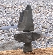
I "think" I found this rock on the coast of one of Washington State's islands. It is a bit greener than it appears in the photos, kind of a "forest green." I was pretty surprised when I did a face cut and found that the pattern continued into the rock . . . Photos are of the rock dry. Green part is a Mohs 7, white seems to vary a bit, some of it seems a bit softer, but I haven't worked it.   |
|
rockbrain
Cave Dweller 
Member since January 2022
Posts: 2,539
|
Post by rockbrain on Oct 3, 2022 18:05:55 GMT -5
Pretty cool looking rock. I don't have enough of a data base established in my brain to be able to id much. The green part of the slice looks a lot like kabamba jasper. The whole thing looks a lot like some ocean jasper I've seen. Of course neither of those makes sense for Washington. It really looks orbicular, I've not seen a lot of Olympic poppy jasper but I don't think I've seen green.
|
|
brybry
Cave Dweller
Enter your message here...
Member since October 2021
Posts: 1,199
|
Post by brybry on Oct 3, 2022 18:17:23 GMT -5
Reminds me of mushroom ryolite.
|
|
hummingbirdstones2
fully equipped rock polisher
 Vince A., 1958-2023
Member since August 2018
Posts: 1,461
|
Post by hummingbirdstones2 on Oct 3, 2022 19:39:04 GMT -5
Yeah, there is Rainforest "Jasper" (actually Rhyolite) in Washington. I'm not accustomed to seeing that color borders on the orbs, though.
|
|
|
|
Post by susand24224 on Oct 3, 2022 19:54:03 GMT -5
The green is denser than what I usually find here in rhyolite; of course I haven't found it all . . . yet. It is also possible that I found it in central Washington in the flood area, which opens up scads of possibilities. I wasn't all that interested in it when I found it since I thought the pattern would be surface only, so it got tossed into the "cut some day" pile. All of you have a point--it is more jaspery to me rhyolite, but with the volcanic activity, it could well be very compressed. I'm going to add a photo of it wet since it shows the colors better--what I thought was pink is actually oranger, like iron oxide.  |
|
|
|
Post by amygdule on Oct 3, 2022 20:59:27 GMT -5
Little Naches, Lilypad Rhyolite is from Central Washington.
|
|
|
|
Post by parfive on Oct 4, 2022 0:45:07 GMT -5
|
|
|
|
Post by susand24224 on Oct 4, 2022 2:59:20 GMT -5
Little Naches, Lilypad Rhyolite is from Central Washington. I think this is it. I looked at a fair number of photos of what was called "lilypad jasper" and there are definite similarities. Most of them are black based, but I found one that was a similar color of green. Thank you! |
|
JR8675309
freely admits to licking rocks

Member since August 2019
Posts: 751
|
Post by JR8675309 on Oct 6, 2022 8:35:09 GMT -5
Reminds me of Lily Pad jasper
From Madras, OR area.
|
|
|
|
Post by susand24224 on Oct 12, 2022 0:11:49 GMT -5
Reminds me of Lily Pad jasper From Madras, OR area. I'm not sure whether I found this on the coast or in Grant/Douglas County, WA, about 200 miles from Madras. But several of the areas in Grant/Douglas were long ago used as "dumping grounds" for rocks that were removed from the Columbia River, particularly when dams were built. So--some of the rocks may not be quite "native," plus it is in the area where the Missoula floods came through, with rocks from Canada on down. Whatever it is, if the material is like the end cut throughout, it is quite solid. Thanks for the information! |
|
khara
fully equipped rock polisher
Member since September 2022
Posts: 1,751
|
Post by khara on Oct 12, 2022 1:21:57 GMT -5
The green is denser than what I usually find here in rhyolite; of course I haven't found it all . . . yet. It is also possible that I found it in central Washington in the flood area, which opens up scads of possibilities. I wasn't all that interested in it when I found it since I thought the pattern would be surface only, so it got tossed into the "cut some day" pile. All of you have a point--it is more jaspery to me rhyolite, but with the volcanic activity, it could well be very compressed. I'm going to add a photo of it wet since it shows the colors better--what I thought was pink is actually oranger, like iron oxide. Really pretty. I'd love to find something like that. I've only found carnelian and petrified wood in Washington and to be honest those got a bit old pretty quick. I think I'm more of a jasper person. |
|
|
|
Post by susand24224 on Oct 12, 2022 1:51:44 GMT -5
[/quote]Really pretty. I'd love to find something like that. I've only found carnelian and petrified wood in Washington and to be honest those got a bit old pretty quick. I think I'm more of a jasper person.[/quote]
Khara, where are you? Maybe I can help point you in the right direction (?) I'll certainly try!
|
|
Sabre52
Cave Dweller
Me and my gal, Rosie
Member since August 2005
Posts: 20,466
|
Post by Sabre52 on Oct 15, 2022 16:29:45 GMT -5
That's called " Geode Matrix" There is a small deposit near the geode beds by the Naches River in Washington state. I have a monster boulder I mined at that deposit.
Apologies, my memory screwed up. My notes say the correct term on the old map I had was "thunderegg matrix". It occurred in a big vein about ten inches thick in a muddy road cut. I got muddy head to toe digging out two big bounders and then gave the best of them, a super pretty one, to a friend to cut a sphere, as it was too big for my saw. He was supposed to give me the trim scraps for cabbing and slabbing but never heard from him again. Basically, it's just mini t-eggs sometimes scrunched together in a greenish to golden rhyolite matrix, very like rainforest jasper. The solid sections with the most t-eggs take good polish. I'll take a couple pics and post them when I have time.
I should have the old map in one of my books. I'll try to post it if I find the driving directions
|
|
Sabre52
Cave Dweller
Me and my gal, Rosie
Member since August 2005
Posts: 20,466
|
Post by Sabre52 on Oct 15, 2022 23:28:22 GMT -5
Little Naches River thunderegg matrix map: From Naches , WA take hwy 12 west to 410 go right on 410, turn right on Little Naches Rd, take another right on forest service rd 1901, you will stay on FR 1901 for several miles but will see turns for FR 715, 716, and 676 don't take them, stay on 1901. You will come to a junction of FR 1901 and FR 723, 723 is a left turn, do not take it, stay on FR 1901. Matrix t-egg site is 2.1 miles from this junction on 1901. The instruction I got said the deposit was on the left side of the road, down slope but I found the best material on the steep muddy bank on the right, uphill side of the road. it is kind of on the high part of FR 1901 so if you start to descend into a canyon, you have passed the site. It was spring when we were there with a little snow but it was a good gravel road and though we had four wheel drive and a high clearance, we really did not need it. I suspect summer would be a piece of cake but a wet spring, you might need that fourby. If you take a left on FR 723 back at the junction, that takes you to the regular thunderegg beds at the end of 723 but we were after the matrix so did not go there because what eggs I had seen were not all that showy and the matrix stuff is pretty cool. I would get the forest service map if I could as the turns are kind of tricky and tend to lead you astray off 1901. It took me awhile to find the 723 junction. Second time I went it was easier. It should also be noted that the Little Naches River gravels you will see along the way contain pet wood and jasper. Suggested gear: I had a long heavy bar and chisels to work the big vein. Rock picks do not do much good in the muddy ash soil, there was a little float when I went but the good stuff required some digging.Probably better in summer as the mud was really bad . Might take rubber boots, rain gear, and mudding clothes at wet times of the year. One of the prettier sites I've ever visited. My wifes sister has a place nearby and the area is beautiful volcanic country.
|
|
|
|
Post by susand24224 on Oct 19, 2022 23:22:34 GMT -5
Little Naches River thunderegg matrix map: From Naches , WA take hwy 12 west to 410 go right on 410, turn right on Little Naches Rd, take another right on forest service rd 1901, you will stay on FR 1901 for several miles but will see turns for FR 715, 716, and 676 don't take them, stay on 1901. You will come to a junction of FR 1901 and FR 723, 723 is a left turn, do not take it, stay on FR 1901. Matrix t-egg site is 2.1 miles from this junction on 1901. The instruction I got said the deposit was on the left side of the road, down slope but I found the best material on the steep muddy bank on the right, uphill side of the road. it is kind of on the high part of FR 1901 so if you start to descend into a canyon, you have passed the site. It was spring when we were there with a little snow but it was a good gravel road and though we had four wheel drive and a high clearance, we really did not need it. I suspect summer would be a piece of cake but a wet spring, you might need that fourby. If you take a left on FR 723 back at the junction, that takes you to the regular thunderegg beds at the end of 723 but we were after the matrix so did not go there because what eggs I had seen were not all that showy and the matrix stuff is pretty cool. I would get the forest service map if I could as the turns are kind of tricky and tend to lead you astray off 1901. It took me awhile to find the 723 junction. Second time I went it was easier. It should also be noted that the Little Naches River gravels you will see along the way contain pet wood and jasper. Suggested gear: I had a long heavy bar and chisels to work the big vein. Rock picks do not do much good in the muddy ash soil, there was a little float when I went but the good stuff required some digging.Probably better in summer as the mud was really bad . Might take rubber boots, rain gear, and mudding clothes at wet times of the year. One of the prettier sites I've ever visited. My wifes sister has a place nearby and the area is beautiful volcanic country. Thank you! I not only appreciate the id information, but also the directions--not too far from me. |
|
khara
fully equipped rock polisher
Member since September 2022
Posts: 1,751
|
Post by khara on Oct 20, 2022 0:26:19 GMT -5
Sabre52 Awesome directions, thank you! What other secret spots do you have up your sleeve?? 🤓
|
|
Sabre52
Cave Dweller
Me and my gal, Rosie
Member since August 2005
Posts: 20,466
|
Post by Sabre52 on Oct 24, 2022 17:15:36 GMT -5
*LOL* I'm kind of an odd duck and seldom use maps as I have a great memory for trails, landmarks etc. Can't remember where I stumbled across this map but since the area was new to me, I kept it in my notebook. Most places, I can drive there but giving map directions etc would be problematic. Not to mention the changes to sites (many totally exhausted) roads etc that happened over my sixty years of hounding. *S*.
|
|


 Al Falfa