|
|
Post by mohs on Jun 9, 2011 22:40:30 GMT -5
A dear friend sent me this photo of Mount Everest that they took on a fly over 
through the front windscreen of a 12 seater plane as I took a Himalaya joyride. You never saw anything so amazing I swears it..[/b] That’s the photographer words & I totally agree! An amazing photo Enjoy Ed |
|
|
|
Post by Toad on Jun 9, 2011 23:13:27 GMT -5
Would be amazing to see in person.
|
|
unclestu
Cave Dweller  WINNER OF THE FIRST RTH KILLER CAB CONTEST UNCLESTU'S AGUA NUEVA AGATE
Member since April 2011
Posts: 2,298
|
Post by unclestu on Jun 10, 2011 6:33:25 GMT -5
That picture gives you a totaly new perspective. Usually when you see a picture of mt Everest it has been taken looking up.
Stu
|
|
|
|
Post by sandsman1 on Jun 10, 2011 7:34:51 GMT -5
wow cool --- lotta cabs in them there hills haha
|
|
|
|
Post by mohs on Jun 10, 2011 10:39:33 GMT -5
Ha Ha guys ! That is a BIG ROCK! Maybe the largest on earth most likely the tallest can only imagine the cabbing marvels those Himalaya have buried  |
|
|
|
Post by parfive on Jun 10, 2011 14:17:35 GMT -5
|
|
|
|
Post by mohs on Jun 10, 2011 15:43:54 GMT -5
That's an amazing list of peak heights Unbelievable the massiveness of the Himalayas "Geologically, the origin of the Himalayas is the impact of the Indian tectonic plate traveling northward at 15 cm per year to impact the Eurasian continent, about 40-50 million years ago. The formation of the Himalayan arc resulted since the lighter rock of the seabeds of that time were easily uplifted into mountains. An often-cited fact used to illustrate this process is that the summit of Mount Everest is made of marine limestone." from Wiki en.wikipedia.org/wiki/Himalayaand still incrementally growing where did all that mass come from? Tethys Sea? and what void did it leave? |
|
|
|
Post by gr on Jun 11, 2011 0:36:49 GMT -5
Cool pic Ed!
Bet it's a lot cooler than Phx right now!
|
|
|
|
Post by mohs on Jun 11, 2011 14:41:40 GMT -5
it is pretty warm in Phoenix today but I got some rock'n done under the umbrella whhoo hooo imagine the friction that was created when India crunched into China! that raised a fuss & holler  |
|
TByrd
fully equipped rock polisher
 Have you performed your random act of kindness?
Member since December 2010
Posts: 1,350
|
Post by TByrd on Jun 11, 2011 14:46:20 GMT -5
Absolutely amazing!!!! ;D ;D Thank you so much for sharing. Tammy  |
|
|
|
Post by mohs on Jun 11, 2011 14:50:57 GMT -5
Hi Tammy the range is amazing & the picture really cool i just found this on wiki 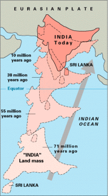 metamorphism --Big time! ready to grind |
|
|
|
Post by mohs on Jun 11, 2011 14:57:14 GMT -5
Steeper southern slopes form along a fault zone called Himalayan Frontal Thrust (HFT); northern slopes are gentler. Permeable conglomerates and other rocks allow rainwater to percolate downslope into the Bhabhar and Terai, supporting only scrubby forests upslope. The Himalayan subtropical pine and broadleaf forests continue here.
gotta love geology
|
|
|
|
Post by parfive on Jun 11, 2011 15:13:00 GMT -5
That map is crrrap, Ed!
71 million years ago, that island was called Ceylon. ;D
|
|
|
|
Post by mohs on Jun 11, 2011 15:28:58 GMT -5
 looks like Ceylon got left behind Rich ! till the government got involved then they went Sri Lankian ;D where is all this heading ? Atlantis? |
|


 Ribbbbit
 Drifting along with the tumblin' tumbleweeds