Holt Canyon Agate Location


Rock Layers

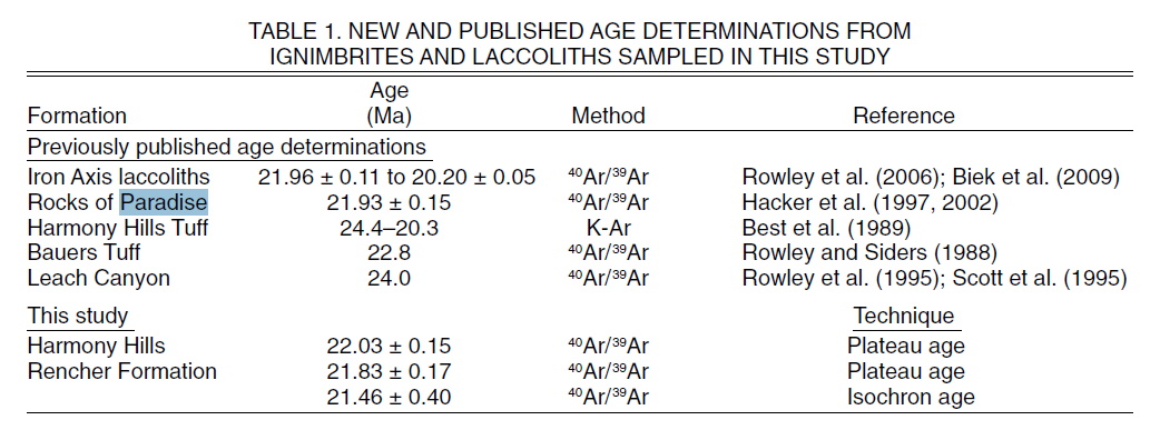
There was a series of volcanic welded tuff flows known as Rocks of Paradise 21.9 Million years ago.

Figure 2. Simplified geologic map of the Pinto Peak intrusion depicting the major geologic units and structural features after D. H. Hacker (Unpublished Geologic Map 1:24000 Page
Ranch Quadrangle).
Rock Abbreviations from youngest to oldest: Tpvr, Rencher Peak flow member of Pine Valley Latite ;
Tpr, Page Ranch formation;
Tpv, Vent sequence of Rocks of Paradise;
Tplu, Upper lava flow member of Rocks of Paradise;
Tpll, Lower lava flow member of Rocks of Paradise;
Tpt, Ash flow tuff member of Rocks of Paradise; Tar, Allochthonous rocks of gravity slide mass;
Tipp, Pinto Peak intrusion;
Th, Harmony Hills Tuff;
Tccb, Bauers Tuff member of Condor Canyon formation;
Tl, Leach Canyon formation;
TI, Isom formation;
Tc, Claron formation;
and Ki, Cretaceous Iron Springs formation.
Then, as the Pine Valley Lacollith Pushed up, there was a landslide to the west.


Tgb Gravity-slide breccia (lower Miocene) – Moderately resistant, mostly pink and gray, tectonic breccia resulting from gravity slides (huge landslides) of various ages, made up of sedimentary (Tc) and volcanic (Tpv, Tcv, Tre, Tpa, Tqh, Ta, Tqc, Tql, Ti, Tw) rocks shed off the roofs of rapidly rising quartz monzonite porphyry laccoliths and stocks (Tipv, Tib, Tih, Tibm, and several others outside the map area) of the Iron Axis (Cook, 1957; Blank, 1959, 1993; Mackin, 1960; Blank and Mackin, 1967; Blank and others, 1992; Hacker and others, 1996, 2002; Hacker, 1998); maximum thickness in the mapped area about 250 feet (75 m).
22MA - Tpa - Rocks of Paradise (lower Miocene) – Resistant to moderately resistant, gray, pink, and red, crystal-rich, dacitic lava flows and poorly to moderately welded ash-flow tuff derived from eruption of the Pinto Peak intrusion, located just north of the map area, and tilted westward by emplacement of the Stoddard Mountain intrusion, also just north of the map area (Hacker, 1998; Hacker and others, 2002); 40Ar/39Ar ages are 21.97 + 0.09, 21.62 + 0.08, and 21.75 + 0.30 Ma on two samples (Rowley and others, 2006), in good agreement with the age of the Pinto Peak intrusion (21.96 + 0.11 Ma; UGS and NMGRL, 2007a); maximum thickness about 600 feet (180 m).
The rocks of Paradise tuff directly underly the Rencher Formation.
1.2. Pinto Peak Intrusion
[4] The Pinto Peak intrusion is an excellent target for a comprehensive study of its anisotropy of magnetic susceptibility (AMS) (Figure 2). The intrusion was emplaced at a shallow level (0.35 km depth), is well exposed (2 km2 ), has well constrained country rock contacts and offers an opportunity for intrusion-scale sampling at a consistent erosional level. In addition, a comparatively rare situation occurs at Pinto Peak in that the subvolcanic intrusive phase and the vent facies crop out in close proximity, allowing for insight into the volcanic-magmatic plumbing system of a hallow level eruptive intrusion. The contact relations between the Pinto Peak intrusion and the country rocks indicate little deformation of the latter.
Bedding contacts are not deflected toward or into parallelism with the intrusion margins and the country rocks are not folded due to emplacement of the intrusion. These contact relationships arguably support the hypothesis that the igneous rocks represent the shallow plumbing system of the Pinto Peak volcano and that the intrusion is not a laccolith.
[5] The Pinto Peak intrusion yielded a 40Ar/39Ar age of 21.9660.11 Ma [Rowley et al., 1998]. The intrusive phase outcrops as low-relief hills extending 2 km northward from the vent area where it plunges beneath the Claron Formation. A second lobe of the intrusion extends southwest from the vent for approximately 2.5 km, gradually becoming wider with a lobe extending to the northwest near the southern part of the exposed intrusion.
The southwest and northwest contacts are covered by the Miocene Leach Canyon Formation and Quaternary alluvium (Figure 2). The vent facies forms several pinnacles of dark-colored rocks rising above the low relief intrusive phase. The vent rocks consist of an intra-vent sequence of ash-flow tuff intruded by dikes of dark gray, glassy porphyritic rocks with various groundmass textures ranging from dense glass to highly vesicular rock. The dikes show a faint vertical flow foliation and grade down into the intrusive facies. The contact between the intrusive phase and vent facies is unexposed. Fragmented Miocene Harmony Hills Tuff forms the vent wall and is in faulted contact with sheared Claron Formation rocks. To the south of the vent, remnants of the Pinto Peak slide mass crop out. The slide mass consists of the Quichapa Group and the Claron Formation. Field mapping reveals that the slide mass once covered the vent area and was subsequently covered by ash flow tuff and lava flows (Rocks of Paradise) erupted from the Pinto Peak volcano [Hacker et al., 2002].

Read More:
agupubs.onlinelibrary.wiley.com/doi/full/10.1002/2013GC004930