Post by transcendental on Aug 28, 2014 16:58:16 GMT -5
Mother in law had the kids so I had a few hours on my own today. Grabbed the dog and headed out to the trail behind the quarry I've mentioned before. Must admit I had higher hopes as far as finding .... something, but the hike was fantastic. Haven't been up there in years and when I did I wasn't focused on the geology just on the hike.
Did a bit of research past 2 days before I decided to go here. The hike goes up bradley mountain which is part of the metacomet ridge. Goes from long island sound coastline up thru connecticut, and Massachusetts ending at the Vermont border. could have done bradley mtn, pinnacle mtn, or ragged mtn, bradley is sandwiched between the other two and happens to be my home town where as pinnacle is in the town above mine and ragged the town under me.
Copied from wiki:
"Bradley Mountain, like much of the Metacomet Ridge, is composed of basalt, also called traprock, a volcanic rock. The mountain formed near the end of the Triassic Period with the rifting apart of the North American continent from Africa and Eurasia. Lava welled up from the rift and solidified into sheets of strata hundreds of feet thick. Subsequent faulting and earthquake activity tilted the strata, creating the cliffs and ridgeline of Bradley Mountain. Hot, dry upper slopes, cool, moist ravines, and mineral-rich ledges of basalt talus produce a combination of microclimate ecosystems on the mountain that support plant and animal species uncommon in greater Connecticut. Bradley Mountain is an important raptor migration path."
More info on the metacomet:
en.m.wikipedia.org/wiki/Metacomet_Ridge
Found a great app that tracks your route over topo maps. Ignore the s, I realized it used tracking without 4G after I stated hiking. I just downloaded it for the gps positioning and the compass in case I strayed too far off the trail looking at rocks. Trail was up the mountain and back down the same way, or it connects to 2 other trails.

Started up the trail that runs up and along this small ravine,

Immediately started finding obvious signs the traprock was once lava. This bubble pitted rock is everywhere! Was hoping for
amygdules in these rocks

Massive boulders litter the forest. I investigated a lot of them looking for mineral veins...nope solid basalt. Just beyond these boulders was a clearing so I went to check it out

It's an underground water pipe line

Just beyond that was the backside of the quarry. Caught a red tail hawk flying overhead in the photo

Glacier deposit. This rock is far from its home. It was so white I thought it was a plastic bag and went to pick it up and realized it was a rock

More evidence of glaciers (from near the top of the mountain)

The trail with rocks everywhere

Trail went from brown to a bright green semi clearing

This is pretty cool, check out their website. Looks like fun, I found it by accident

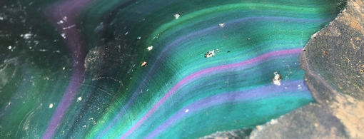
Only type of veining I found in the 2.5 hours I was out

Start getting near the top and 20 ft tall outcroppings start appearing along the trail.
Top of the mountain heading towards the cliff

Very tired dog lol

View from the cliff. Mountain with the steep face is pinnacle and further beyond it is a mountain called sleeping giant because... well it looks like a giant laying on its back.
The lake below has a very easy trail around it that I take the kids to.

Sat for a bit and rehydrated enjoying the view and the breeze. Dog was so happy he started rolling around on the lichen covered rock lol

Back home with the few little pocket stones i picked up along the way

Ready for a nap now
Thanks for looking
Did a bit of research past 2 days before I decided to go here. The hike goes up bradley mountain which is part of the metacomet ridge. Goes from long island sound coastline up thru connecticut, and Massachusetts ending at the Vermont border. could have done bradley mtn, pinnacle mtn, or ragged mtn, bradley is sandwiched between the other two and happens to be my home town where as pinnacle is in the town above mine and ragged the town under me.
Copied from wiki:
"Bradley Mountain, like much of the Metacomet Ridge, is composed of basalt, also called traprock, a volcanic rock. The mountain formed near the end of the Triassic Period with the rifting apart of the North American continent from Africa and Eurasia. Lava welled up from the rift and solidified into sheets of strata hundreds of feet thick. Subsequent faulting and earthquake activity tilted the strata, creating the cliffs and ridgeline of Bradley Mountain. Hot, dry upper slopes, cool, moist ravines, and mineral-rich ledges of basalt talus produce a combination of microclimate ecosystems on the mountain that support plant and animal species uncommon in greater Connecticut. Bradley Mountain is an important raptor migration path."
More info on the metacomet:
en.m.wikipedia.org/wiki/Metacomet_Ridge
Found a great app that tracks your route over topo maps. Ignore the s, I realized it used tracking without 4G after I stated hiking. I just downloaded it for the gps positioning and the compass in case I strayed too far off the trail looking at rocks. Trail was up the mountain and back down the same way, or it connects to 2 other trails.
Started up the trail that runs up and along this small ravine,
Immediately started finding obvious signs the traprock was once lava. This bubble pitted rock is everywhere! Was hoping for
amygdules in these rocks
Massive boulders litter the forest. I investigated a lot of them looking for mineral veins...nope solid basalt. Just beyond these boulders was a clearing so I went to check it out
It's an underground water pipe line
Just beyond that was the backside of the quarry. Caught a red tail hawk flying overhead in the photo
Glacier deposit. This rock is far from its home. It was so white I thought it was a plastic bag and went to pick it up and realized it was a rock
More evidence of glaciers (from near the top of the mountain)
The trail with rocks everywhere
Trail went from brown to a bright green semi clearing
This is pretty cool, check out their website. Looks like fun, I found it by accident
Only type of veining I found in the 2.5 hours I was out
Start getting near the top and 20 ft tall outcroppings start appearing along the trail.
Top of the mountain heading towards the cliff
Very tired dog lol
View from the cliff. Mountain with the steep face is pinnacle and further beyond it is a mountain called sleeping giant because... well it looks like a giant laying on its back.
The lake below has a very easy trail around it that I take the kids to.
Sat for a bit and rehydrated enjoying the view and the breeze. Dog was so happy he started rolling around on the lichen covered rock lol
Back home with the few little pocket stones i picked up along the way
Ready for a nap now

Thanks for looking