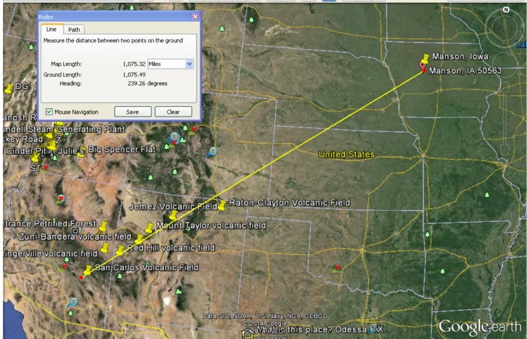
The Raton NM - San Carlos AZ Hotspot Enigma.
Dec 31, 2014 15:04:22 GMT -5
iant and snowmom like this
Post by 1dave on Dec 31, 2014 15:04:22 GMT -5
Raton Hotspot:
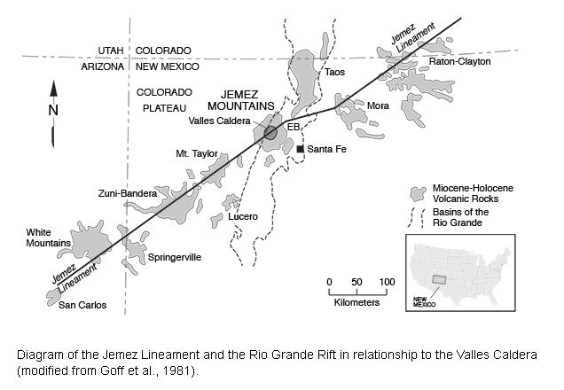
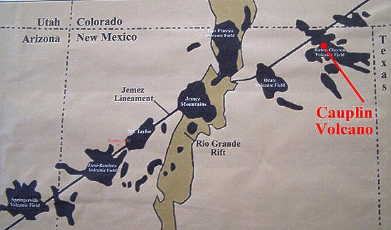
Jemez Lineament
From Wikipedia, the free encyclopedia
(Redirected from Raton hotspot)
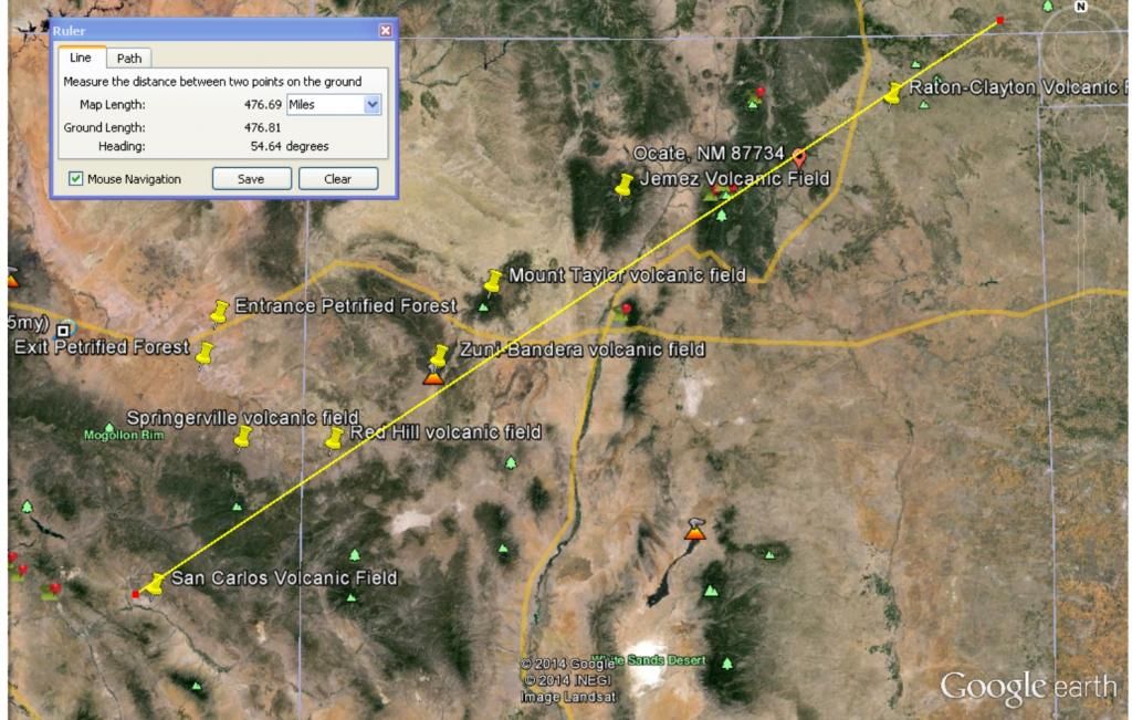
The Jemez Lineament (Raton hotspot trail) corresponds to a series of faults, 600 km long, from Springerville and White Mountains volcanic fields in East-Central Arizona to Raton-Clayton volcanic field in Northeastern New Mexico.[1]
Volcano fields
The Jemez Lineament (Raton hotspot trail) consists of (p286) the San Carlos volcanic field, (p284) Springerville volcanic field, (p.306) Red Hill volcanic field,[1] (p303) Zuni-Bandera volcanic field, (p.300) Mount Taylor volcanic field, (p.295) Jemez volcanic field and possibly the (p 293) Ocate volcanic field, (p.292) Raton-Clayton volcanic field, and Mesa de Maya.
(Page numbers inserted from Volcanoes of North America by Wood & Kienle- Dave Crosby)
Lipman (1980) rules out a hotspot origin, as there is no systematic progression of age.[1] This faulting probably reflects the combined effects of faster spreading in the Española Basin than the area North of the lineament (Abiquiu embayment and San Luis Basin), the right step in the Rio Grande rift zone that juxtaposes the San Luis Basin (Taos Plateau) against the Picuris Mountains, and counterclockwise rotation of various crustal blocks within the rift zone.[2]
The Yellowstone hotspot trail was modified through faulting and extension of the Basin and Range Province, so this lineament shows more accurately the movement of the North American Plate.[3]
References
Wood, Charles Arthur; Kienle, Jürgen (1992). Volcanoes of North America: United States and Canada. Cambridge University Press. pp. 284–286. ISBN 978-0-521-43811-7.
Aldrich Jr., M. J. (1986). "Tectonics of the Jemez Lineament in the Jemez Mountains and Rio Grande Rift". Journal of Geophysical Research 91 (B2): 1753–1762. Bibcode:1986JGR....91.1753A. doi:10.1029/JB091iB02p01753.
W. Jason Morgan and Jason Phipps Morgan. Plate velocities in hotspot reference frame: electronic supplement. p. 111. Retrieved 2010-04-23.
Jemez Lineament
From Wikipedia, the free encyclopedia
(Redirected from Raton hotspot)
The Jemez Lineament (Raton hotspot trail) corresponds to a series of faults, 600 km long, from Springerville and White Mountains volcanic fields in East-Central Arizona to Raton-Clayton volcanic field in Northeastern New Mexico.[1]
Volcano fields
The Jemez Lineament (Raton hotspot trail) consists of (p286) the San Carlos volcanic field, (p284) Springerville volcanic field, (p.306) Red Hill volcanic field,[1] (p303) Zuni-Bandera volcanic field, (p.300) Mount Taylor volcanic field, (p.295) Jemez volcanic field and possibly the (p 293) Ocate volcanic field, (p.292) Raton-Clayton volcanic field, and Mesa de Maya.
(Page numbers inserted from Volcanoes of North America by Wood & Kienle- Dave Crosby)
Lipman (1980) rules out a hotspot origin, as there is no systematic progression of age.[1] This faulting probably reflects the combined effects of faster spreading in the Española Basin than the area North of the lineament (Abiquiu embayment and San Luis Basin), the right step in the Rio Grande rift zone that juxtaposes the San Luis Basin (Taos Plateau) against the Picuris Mountains, and counterclockwise rotation of various crustal blocks within the rift zone.[2]
The Yellowstone hotspot trail was modified through faulting and extension of the Basin and Range Province, so this lineament shows more accurately the movement of the North American Plate.[3]
References
Wood, Charles Arthur; Kienle, Jürgen (1992). Volcanoes of North America: United States and Canada. Cambridge University Press. pp. 284–286. ISBN 978-0-521-43811-7.
Aldrich Jr., M. J. (1986). "Tectonics of the Jemez Lineament in the Jemez Mountains and Rio Grande Rift". Journal of Geophysical Research 91 (B2): 1753–1762. Bibcode:1986JGR....91.1753A. doi:10.1029/JB091iB02p01753.
W. Jason Morgan and Jason Phipps Morgan. Plate velocities in hotspot reference frame: electronic supplement. p. 111. Retrieved 2010-04-23.
No Age Progression, and yet . . .

so this lineament shows more accurately the movement of the North American Plate.[3]
Left off the map is the San Carlos Volcanic Field, perhaps the most informative part of the "Jemez Lineament."
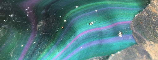
San Carlos volcanic field is a monogenetic (erupts only once) volcanic field in Arizona. The field lies within the San Carlos Apache Reservation about 40 km (25 mi) east of Globe, Arizona. It is a small field covering approximately 50 km2 or less of volcanic cones and lava flows. The basanite to hawaiite basaltic flows contain xenoliths of peridotite. The Peridot Mesa vent is noted for the occurrence of quantities of gem quality peridot found within lherzolite xenolith nodules.[1]
Notable Vents
Name Elevation Coordinates Last eruption
Aden Crater[1] - - -
Peridot Mesa[1] - 33°20?02?N 110°29?08?W -
San Carlos Volcanic Field
Elevation 1,000 m (3,300 ft)[1]
Location
Location Arizona, United States
Coordinates 33°15?N 110°15?W Coordinates: 33°15?N 110°15?W[1]
Geology
Type Volcanic field[1]
Age of rock Neogene[1]
Last eruption ~ 1 million years ago[1]
References: Wood, Charles A.; Ju"rgen Kienle (1993). Volcanoes of North America. Cambridge University Press. pp. 310–313. ISBN 0-521-43811-X.
Luckily, I have the book in my library, and the actual reference is to page 286.
From day one, geologists have been unable, or unwilling, to distinguish between impact and volcanic phenomena.
Before Gene Shoemaker, everything melted HAD TO BE volcanic, and there were no impact craters.
Shattercones and shocked quartz has forced the acceptance of around half of the visible continental impact craters.
Ten years ago, the discovery of the Ewing 150 Km Diameter 7 - 11 million year old crater in the Pacific
provided the opportunity of recognizing oceanic impact sites. Few have taken the opportunity to learn.
In 1963, J. Tuzo Wilson came up with the idea that volcanic chains like the Hawaiian Islands result from the slow movement of a tectonic plate across a "fixed" hotspot deep beneath the surface of the planet.
The term "mantle plume" was coined, and once we had a label it became gospel fact.
Disturbing observations are forcing thinking people to search for a new explanation for hotspots.
For me, to only possibility is major impacts.
Above I quoted:
Lipman (1980) rules out a hotspot origin, as there is no systematic progression of age.
This all seems to have happened around 4 million years ago. And they all erupted only once!
What if: Those "xenolith nodules" are actually parts of an asteroid, and the entire Jemez Lineament - Raton hotspot trail is actually an impact train and strewn field?
Anyone excited enough to try and check it out?