Two days in the Blue Ridge mountains
Feb 1, 2015 8:01:24 GMT -5
quartz, rockpickerforever, and 7 more like this
Post by jamesp on Feb 1, 2015 8:01:24 GMT -5
Went up to the mountains to hunt for garnets and explore old haunts. Area is around North Carolina/Georgia border.
Average elevation at road level was 3000 feet, peeks to 5500 feet. Mere foot hills to westerners. Mountains are small, steep and close
together creating creeks and springs and many draws. Very confusing, add thick mature hardwoods and impenetrable mountain laurel.
Deciduous trees are naked and greatly improves navigation, traveling ridges is about the only way to traverse distance.
Reference points are adjacent mountain peeks, often having to climb to a ridge to get a view of the higher points for orientation.
Most of my experience was hog hunting following dogs. Average hunt was 25 miles starting about 4AM and ending same afternoon. winter
In younger days. Most of us are all crippled now from worn out joints ha.
Hunting was done by ascending to a ridge and hiking hill to hill till the wind blew a scent. Hogs in down bottoms.
As soon as dogs scented it was fast and furious down the shortest route, of course the steepest.
The hog's ploy was to run up the steepest route from the bottoms in an attempt to foil the dogs.
And then back down the steepest route.
We would end up about 1-5 miles somewhere, and my mountain friend could navigate us back, some how.
An older mountain man often went with us, 30 years our senior. He would leave us in the dust. Pulse 33. Healthy fellow.
typical terrain-uphill

typical downhill, we wore thick pants and slid down hill half the time

A normal hunt would easily be to and along the ridge in the back ground

The dogs would start to bark and howl once hogs were bayed. Always in a creek, where the dogs were unable to move fast.
It was urgent to get to the dogs before they got injured. If it was a long haired Russian boar the dogs often got hurt.
Even if it was a small 100 pounder. No wild hog like a pure blood Russian

To keep our foot gear light weight we wore leather boots. A trash bag was worn on each leg for creek crossings to keep boots dry.

Tried to stay on the dryer sunnier side of the mountain to avoid impenetrable mountain laurel. A bear can fly thru this stuff.
And can dust the dogs in it. The limbs layer, so it forms hoops that trip up most animals including humans. North facing
slopes are completely different biologically, herbaceous plants, shrubs and trees. South facing slopes carpeted w/leaves. Easy sailing.

A small grouping of mountain laurel

A normal starting point, car a few miles from ridge. No trails after departure.

Standing Indian mountain at 5499 feet. Frozen rain coating hardwoods, telling on all mountains over 5000 feet this day.
Photo at 3400 feet in Buck Creek draw.

A 5000+ ridge line with iced over trees viewed from a pass along Hwy 64 in the Nantahala National forest.
Guessing 5-8 miles off. Hwy 64 popular cycle route.

Cut through mountain, Hwy 64. Other side of cut is ice free. On the sunny side. Hardwoods at top 80-100 feet tall.

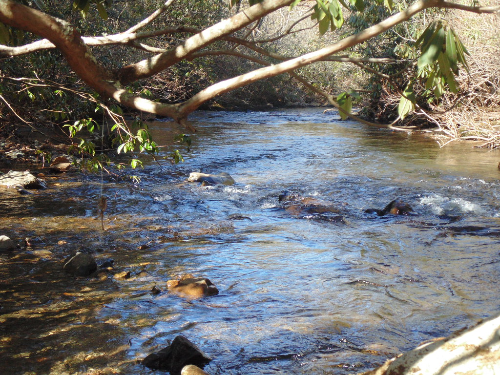
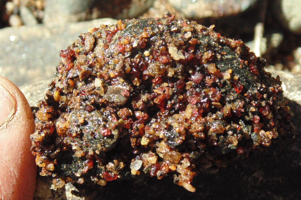
Probably crossed 100 creeks and springs on the higher elevation forestry roads. About 4 of them tested positive for gem grade garnet sand.

Test easy, pick up rock along shore in outside of creek turn where sand was pushed up against the bank. Garnets
stick to bottom of rock.

Flat land uncommon and valuable. About all flat land rich in artifacts. And occupied in farms.

Most of the highland uninhabited. Dry day and it is still 'smokey'.

A common form of aquaculture. Diverted high oxygen creeks that support heavy populations of trout in small pond.
Many with auto feeders, tasty crop for land owner

Will go back in warm weather and work creeks for garnets. They have high density and settle in deep pockets like gold.
The best find of the trip is a peculiar garnet/black biotite polka dotted quartzite found in one tributary.
Will have to saw it to see how good it looks. It lacks felspar and is very dense. Rich in pink garnet 'melts', speckled throughout.
In cobbles, ringing with a high pitch when tapped with a hammer.
Thanks for looking, will get some photos up of this peculiar quartzite.
Average elevation at road level was 3000 feet, peeks to 5500 feet. Mere foot hills to westerners. Mountains are small, steep and close
together creating creeks and springs and many draws. Very confusing, add thick mature hardwoods and impenetrable mountain laurel.
Deciduous trees are naked and greatly improves navigation, traveling ridges is about the only way to traverse distance.
Reference points are adjacent mountain peeks, often having to climb to a ridge to get a view of the higher points for orientation.
Most of my experience was hog hunting following dogs. Average hunt was 25 miles starting about 4AM and ending same afternoon. winter
In younger days. Most of us are all crippled now from worn out joints ha.
Hunting was done by ascending to a ridge and hiking hill to hill till the wind blew a scent. Hogs in down bottoms.
As soon as dogs scented it was fast and furious down the shortest route, of course the steepest.
The hog's ploy was to run up the steepest route from the bottoms in an attempt to foil the dogs.
And then back down the steepest route.
We would end up about 1-5 miles somewhere, and my mountain friend could navigate us back, some how.
An older mountain man often went with us, 30 years our senior. He would leave us in the dust. Pulse 33. Healthy fellow.
typical terrain-uphill

typical downhill, we wore thick pants and slid down hill half the time

A normal hunt would easily be to and along the ridge in the back ground

The dogs would start to bark and howl once hogs were bayed. Always in a creek, where the dogs were unable to move fast.
It was urgent to get to the dogs before they got injured. If it was a long haired Russian boar the dogs often got hurt.
Even if it was a small 100 pounder. No wild hog like a pure blood Russian

To keep our foot gear light weight we wore leather boots. A trash bag was worn on each leg for creek crossings to keep boots dry.

Tried to stay on the dryer sunnier side of the mountain to avoid impenetrable mountain laurel. A bear can fly thru this stuff.
And can dust the dogs in it. The limbs layer, so it forms hoops that trip up most animals including humans. North facing
slopes are completely different biologically, herbaceous plants, shrubs and trees. South facing slopes carpeted w/leaves. Easy sailing.

A small grouping of mountain laurel

A normal starting point, car a few miles from ridge. No trails after departure.

Standing Indian mountain at 5499 feet. Frozen rain coating hardwoods, telling on all mountains over 5000 feet this day.
Photo at 3400 feet in Buck Creek draw.

A 5000+ ridge line with iced over trees viewed from a pass along Hwy 64 in the Nantahala National forest.
Guessing 5-8 miles off. Hwy 64 popular cycle route.

Cut through mountain, Hwy 64. Other side of cut is ice free. On the sunny side. Hardwoods at top 80-100 feet tall.

Probably crossed 100 creeks and springs on the higher elevation forestry roads. About 4 of them tested positive for gem grade garnet sand.

Test easy, pick up rock along shore in outside of creek turn where sand was pushed up against the bank. Garnets
stick to bottom of rock.

Flat land uncommon and valuable. About all flat land rich in artifacts. And occupied in farms.

Most of the highland uninhabited. Dry day and it is still 'smokey'.

A common form of aquaculture. Diverted high oxygen creeks that support heavy populations of trout in small pond.
Many with auto feeders, tasty crop for land owner

Will go back in warm weather and work creeks for garnets. They have high density and settle in deep pockets like gold.
The best find of the trip is a peculiar garnet/black biotite polka dotted quartzite found in one tributary.
Will have to saw it to see how good it looks. It lacks felspar and is very dense. Rich in pink garnet 'melts', speckled throughout.
In cobbles, ringing with a high pitch when tapped with a hammer.
Thanks for looking, will get some photos up of this peculiar quartzite.


 .
.


