|
|
Post by 1dave on Jul 5, 2017 0:54:38 GMT -5
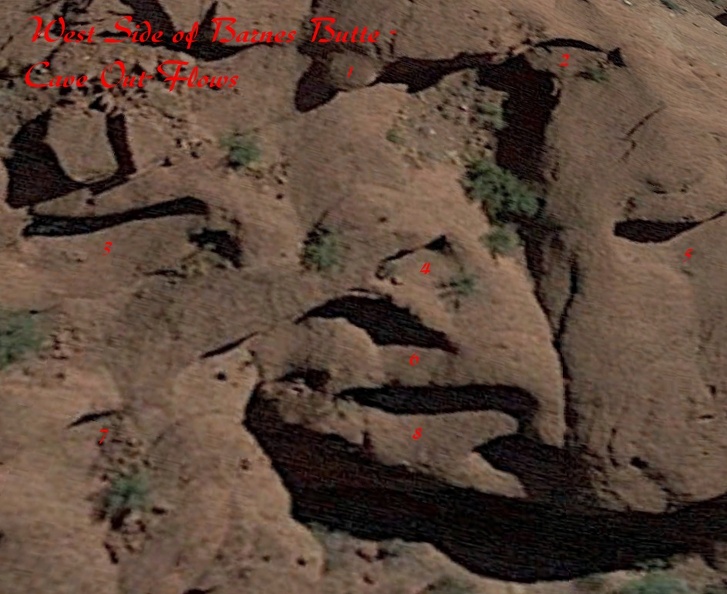
Hi mohs , I spent most of the day on Google Maps and Google Earth searching images on the Papago Buttes. I got some great images, but no one else seems interested in the "Tongue out of Mouth" cave photos. I snagged this one of the west side of Barnes Butte:  I now see three more I could have counted! |
|
|
|
Post by mohs on Jul 5, 2017 10:16:10 GMT -5
Amazing!
Without even knowing where those pictures came from I would recognize them!
Are these cave formation unique to this area?
Is there anywhere else on earth that have these same geological features?
Qumran Caves?
How did the caves form?
|
|
|
|
Post by 1dave on Jul 5, 2017 13:05:56 GMT -5
They must have formed just the way it looks like they did. 1. A great many Moons ago the granite base of the Papago Buttes were covered by a fluvial landslide. 2. As flood waters receded, unstable saturated sections flowed out of the mass, creating the caves. 3. As the "tongues" dried they solidified. The many photos I've looked at answers my question about why the people of Cibola never did anything with them. Perhaps they did, but the material crumbles so easily that all attempts are quickly ruined. Even modern spray paint graffiti self destructs within a few years. They really need to do a study on how rapidly they are eroding.  All conglomerate around the boulder in the red square has weathered away. Modern graffiti is disappearing. |
|
|
|
Post by 1dave on Jul 5, 2017 13:42:53 GMT -5
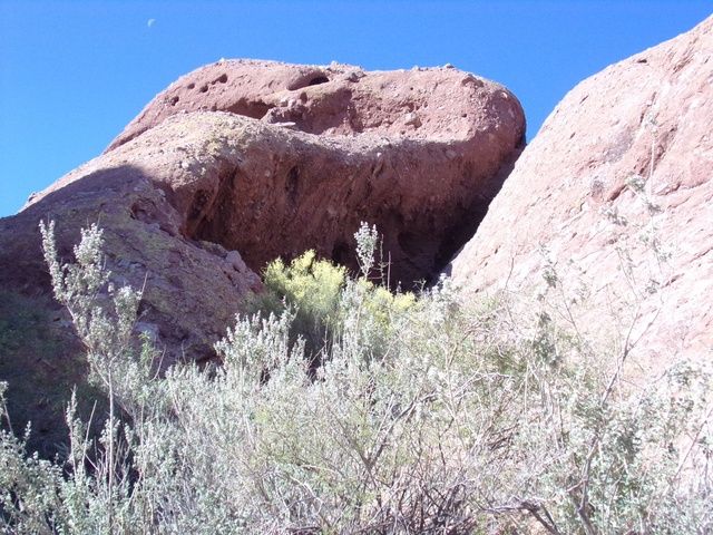
Division between the Barnes Fluvial Conglomerate and underlying material is revealed in this Photo. Note the overhead rocks weathering out and prepared to soon fall.  A "tongue" near the Hole in the Rock shows that there was once a "tongue" there too.  |
|
|
|
Post by 1dave on Jun 5, 2018 10:15:54 GMT -5
Thanks Dave!!! Those are some valuable pictures you posted! I really appreciate it! I do believe you’re onto the truth 10000year haboob w/a Noahic mud flow cataclysm I’m going to have go up there soon and follow your line of thinking I didn’t concentrate my photos on the mudflow caves This is my best shot Presently  Old Mind of mine, new thoughts? I was reviewing this morning. repository.azgs.az.gov/sites/default/files/dlio/files/nid1413/tempegi-2-eside2.pdfThe red *'s are Papago Buttes.  A huge flood from Salt Creek Canyon undoubtedly wiped out the Cibola Civilization, but I'm thinking the hanging tongues came from elsewhere.
 My best GUESS is that
1. 13,000 years ago ice melted, then water poured down from Cave Creek carving out Paradise Valley and depositing the muddy purple colored Zoo Breccia Member on top of the buttes and surrounding area. 2. Some time later a repeat flood dumped the reddish-brown Barnes Butte Breccia Member on top of everything. 3. Moisture from the 2nd flood liquefied the underlying mud in the purple Zoo member, and it spilled out around the butte edges, creating the caves and hanging tongues. My lightening fast mind only took a year to figure that out. Dave
|
|
|
|
Post by mohs on Jun 5, 2018 10:46:51 GMT -5
Thanks Dave
it was year to the date
we tried to reformulate
'the occurrence’
Those Papago’s sit as somnolent sentinel’s
solid in their solvency
That map show the 1891 flood
This is key
Jacob Waltz was rescued from a mesquite tree
one version of the lore
Keeps me searching for a heart of gold...
mohs
and who was jacob weiser?
|
|
|
|
Post by 1dave on Jun 6, 2018 14:23:54 GMT -5
Thanks Dave it was year to the date we tried to reformulate 'the occurrence’ Those Papago’s sit as somnolent sentinel’s solid in their solvency That map show the 1891 flood This is key Jacob Waltz was rescued from a mesquite tree one version of the lore Keeps me searching for a heart of gold... mohs and who was jacob weiser? Back to the Buttes. I think the Zoo Breccia came from near Carefree:  Then the area to the north broke loose through the narrow pass to cover everything with the Barnes Butte Breccia -  |
|
|
|
Post by mohs on Jun 6, 2018 15:50:30 GMT -5
That is my understanding too, Dave
At least according to the geologist survey
They have found the same red beds in Carefree
As what is in the Papago's
Previously in this thread a
a serious analysis was proffered
On the amount of material
and the height of a mud flow
it would take to create the Papago’s
the cause of that cataclysm
(indeed if that is origins of the Papago )
remains to be extrapolated….
m
|
|
|
|
Post by mohs on Jun 9, 2018 14:06:47 GMT -5
This is my take on how the Papago Butte's were formed
it includes 5 or 6 distinct geological forces that conspired to bring about the Phoenix Basin.
1st speculation:
A major underground uplift occurred during the Proterozoic age.
Metamorphic rocks, including metavolcanic rocks, metasedimentary rocks,
plus foliated gneissic plutonic rocks
were rumbling & tumbling deep in the earth.
Eventually creating some sort of stable bedrock
2nd speculation
Sometime during the early Tertiary period volcanic ash & lava flow
(from the Superstition Mountains eruptions)
seriously covered the area in pryroclastic ash.
3rd speculation
The Basin is the inundated from a huge mountain (most likely the Mogollon) that crumbed into a landslide.
What caused this mountainous slide must of been voluminous volcanic & quake activity.
Perhaps from a meteor? There is Meteor Crater in the Winslow area.
Heavy speculation.
Nonetheless evidence of that mountainous shear rim remains.
In step by step procedure mountains of rumble formed, weathered, broke & re-slid progressively down/|
There is some land scarring evidence of this--- again speculative.
4th speculation
Salt River gravels then invaded the area transported by the Salt River.
If you have ever travel the Salt River Canyon --your in for a real treat!--
it is easily imaginable to understand the amount earth that was excavated
from that area and created that awesome Canyon.
5th speculation
Uppermost Alluvium deposits.
So all these layers built on top of one another over the millenniums.
Unimaginable thickness.
Last speculation:
Then the South Mountain Metamorphic Complex occurred.
(SMMC)
This further ripped and buckled the land.
This is what raised the buttes and caused them to alter and shift their strata layers.
Some speculate this occurred as far back as 25 million years. But I remain skeptical
Well that my synopsis
Lots of holes & pockmarks in it
But as those geologist remarked:
Lost in the recipe are millions of years of geological history not accounted for.
So some speculation will have to suffice… mostly
|
|
|
|
Post by 1dave on Jun 10, 2018 2:32:28 GMT -5
Right on mohs! I understand the Phoenix area surface was scoured right down to the Precambrian bedrock of granite and gneiss just prior to the Zoo Breccia being laid down.  |
|
|
|
Post by 1dave on Jun 10, 2018 3:08:44 GMT -5
|
|
|
|
Post by 1dave on Jun 10, 2018 3:10:41 GMT -5
Note that the above never mentions the Zoo and Barnes Butte Breccias.
|
|
|
|
Post by mohs on Jun 10, 2018 9:46:32 GMT -5
Yes!
Barnes breccias and the Salt River Canyon excavation
No mention.
The unconformity of the missing geologic history
Could the unconformity be the comet debris
as extrapolated in Peterson's theory ?
I”ll have to redelve into historical forces....
till then
Mohs
|
|
|
|
Post by 1dave on Jun 10, 2018 10:46:13 GMT -5
I have serious doubts about the comet. BUT something very serious happened 13,000 years ago. Wiped out early man in America along with most of the animals. The end of the ice age. The "Black Mat" cover on butchered animals etc. mat filled with nano-diamonds. What else?  |
|
|
|
Post by mohs on Jun 10, 2018 11:28:53 GMT -5
Yes! That what I been concerned about!
Peterson may have been over zealous in his comet theory
In example: trying to sale books to a wider audience
What if the comet debris occurrence
happened more in your time frame.
13,000 thousand years ago ?
Peterson had the loess theory down for the building of the Papago’s
He might have just fudged the numbers....
|
|
|
|
Post by mohs on Jun 20, 2018 9:43:46 GMT -5
serious study of why the Hoho abandoned their communities.
The best I can come up with is that the population grew too fast,
water source was unreliable
maintaining of canals became to unwieldy,
and hierarchical politics became overbearing.
A shame! What started as a fine communal effort descended into a 'me only' farce!
What can we learn from this? Well nothing.
We are humans... all to human after all....
|
|
|
|
Post by grumpybill on Jul 12, 2018 20:00:09 GMT -5
One possibility that is often overlooked when trying to figure out why ancient communities, and even entire civilizations, is: Disease.
When people live and work in closely compacted groups, diseases (especially newly introduced ones) spread quickly/easily.
People in the community/city notice that they are getting sick/dying while those "out in the boonies" aren't affected, so they abandon the city and head for the hills.
|
|
|
|
Post by 1dave on Jul 13, 2018 9:52:18 GMT -5
The flood scoured villages and buildings and canals buried in mud give hint, as does the prolonged historical list of floods racing out of Salt Canyon. One of those "Hundred Year Floods" got them.
|
|
|
|
Post by 1dave on Jul 13, 2018 9:55:37 GMT -5
A little study of history verifies they called themselves the people of Cibola."
Why do archaeologists insist on calling them by their enemies name, the Hohokam - "The worn out people" ?
|
|
|
|
Post by mohs on Jul 13, 2018 12:11:51 GMT -5
 Hohokam were named by the Tohono O'odham tribe which in their dialect means ‘the worn out people' An interesting term Worn out ? From what? Not from any one catastrophe Flood. drought…ect But from a long difficulty of maintaining the canals This could have led to internal dissension Things break down Wear out Entropy Rules |
|