Post by 1dave on May 21, 2018 23:33:13 GMT -5
Oil tends to collect in the bottom of impact basins, so . . .


Who would have thunk it? - My guess is radioactivity (autunite) is responsible for the fluorescence.


geology.utah.gov/docs/pdf/lls_finalrpt.pdf
Discussion
Epifluorescence allows one to observe the presence of any soluble hydrocarbons.
Samples displaying fluorescence represent areas where hydrocarbons may have migrated or
accumulated.
The best fluorescence, when present, was gold and occurred in high porosity (figure 6-4A), low permeability dolomites (thus the major reason the collection effort concentrated on porous dolomites).
Pale-yellow fluorescence indicated possible high-gravity oil (figure 6-4B).
If no fluorescence was observed in porous dolomites, the samples were also good representatives of areas where hydrocarbons had not migrated or accumulated. Bitumen (pyrobitumen) was common in many samples. It has no activity within the hydrocarbon molecules and therefore does not fluoresce (figure 6-4D).
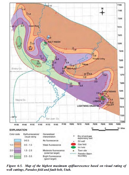
As expected, productive Leadville wells (fields such as Lisbon and Salt Wash) have cuttings distinguished by generally higher EF readings (figures 6-5 and 6-6). However, a regional southeast-northwest trend of relatively high EF from Leadville cuttings parallels the southwestern part of the Paradox fold and fault belt from Lisbon field to west of the town of Green River. A visual reading of 2.0 to 3.0 for the highest maximum EF (figure 6-5) and 2.0 to 2.5 for the highest average EF (figure 6-6) occur in this region. The northeastern part of the fold and fault belt shows a regional trend of low EF including a large area of essentially no EF (a visual reading of less than 0.4 for the maximum highest average EF) centered around the town of Moab (figure 6-6).
These EF maps imply hydrocarbon migration and dolomitization was associated with regional northwest-trending faults and fracture zones, which created potential oil-prone areas along the southwest trend. Hydrocarbons may have migrated from organic-rich shales in the Pennsylvanian Paradox Formation where they are in contact with the Leadville Limestone along faults.
Hydrothermal alteration associated with these faults and related fracture zones may have generated late, porous dolomite and thus produced diagenetic traps indicated by EF.
Alternative interpretations for the lack of significant EF in the northeast trend is the possibility that
(1) most hydrocarbons may have been flushed out to the southwest by hydrodynamic processes, and
(2) the northeast part of the Paradox fold and fault belt has passed the oil window and gone into the dry gas/post-oil window stage maturation.
A final explanation is that these EF trends could be related to facies or karst development in the Leadville Limestone. At any rate, the mapping of hydrocarbon shows based on EF indicates exploration efforts should be concentrated in suggested oil-prone areas along the southwest part of the Paradox fold and fault belt.
Who would have thunk it? - My guess is radioactivity (autunite) is responsible for the fluorescence.


