|
|
Post by 1dave on Jun 6, 2018 12:51:12 GMT -5
|
|
|
|
Post by 1dave on Jun 6, 2018 13:15:20 GMT -5
|
|
pizzano
Cave Dweller 
Member since February 2018
Posts: 1,390
|
Post by pizzano on Jun 6, 2018 13:44:38 GMT -5
Topozone is a nice & convenient little tool Google has implemented for macro imagery with (the help of esri's ArcGIS/GPS and ClearTerra applications).......we use similar applications at work when we fly (UAV) topography photogrammetry surveys of future development sites, rough grading design, infrastructure location/coordination and parcel map boundary re-trace examination.........kind of my "bread and butter" making a living, that and ground control base station implementation......!
|
|
|
|
Post by mohs on Jun 6, 2018 14:31:36 GMT -5
Very cool Dave !
I don’t do enough internet map searching
A person can get lost for hours
It’ is such amazing technology
Just to point out the
Pueblo Grande Museum
The main Hohokam site
Is on the south east corner
Between 44st & the 143 Highway on Washington St.
----(It is such a marvel to enter that freeway and look down on the ancient preserved site.
Such a contrast to the later Phoenix megalopolis
for better or worse ) -----
Its probably denoted by that outlined circle on the 3rd map down from the top.
It was from the platform mound that Jack Swilling (and couple other early pioneers)
named Phoenix, A city arising from the ancient canal system.
And that what Swilling did. Started the Swilling Ditch Company,
Re-digging out those old ancient canals.
They really couldn't improve ( or there was no need to)
on the Hohokam original gradients.
What else those early miners were digging for remains a mystery …
Understandably for miles around the Hohokam farmed this vast area with their innovative canals.
On both the north & south side of the Salt River.
The Swilling Canal Project later made Phoenix into and agriculture center,
specializing in cotton citrus cattle ect... and lots of other scams ha ha
So what drove the Hookam into abandonment of their land?
That remains mysterious.
The year around 1450 needs to be studied more…
|
|
jamesp
Cave Dweller 
Member since October 2012
Posts: 36,607
|
Post by jamesp on Jun 6, 2018 14:39:58 GMT -5
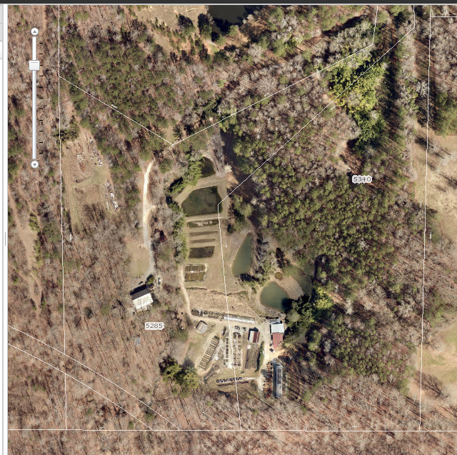
I guess you guys don't have so many wet lands. My 30 acres has 4 wetland zones where the 4 creeks are. I dammed one of the creeks and piped the water 2600' in 6" PVC to wetland and upland areas for ponds about 35 years ago. Gravity flow water to 15 acres. Grew wetland plants for 29 years, closed it down this year. Getting ready to sell lot 5340 @ 17 acres and move property line to catch all ponds. Big stack of Rio Grande agates over there if you buy it  . Warning - I'm a noisy neighbor. That's me skinny dipping in the long slender pond.  |
|
|
|
Post by oregon on Jun 6, 2018 19:15:31 GMT -5
just in case any one doesn't know, you can also turn on contour lines on google maps, under the location menu, click on the menu button (hamburger) and select terrain. (only shows at certain zoom levels, not too close, or too far). Nice to be able to toggle with Sat. imagery, and the 3D lidar data is also helpful...  goo.gl/maps/umWJfbXMcMT2 goo.gl/maps/umWJfbXMcMT2 |
|