|
|
Post by 1dave on Dec 12, 2019 21:51:26 GMT -5
earthquake.usgs.gov/data/crust/nam.php  Figure 2. Crustal Thickness in kilometers, derived from a comprehensive compilation of seismic refraction and reflection data, earthquake studies, and surface wave analyses. One feature of this map is an extension of the thin crust of the Basin and Range Province into Western Canada. The contour interval is 10 km; a contour representing 45 km (dashed line) is also included. Many well-known features are reproduced here, such as the thin crust of the Basin and Range and the thick crust of the US Great Plains and Midcontinent. The map also reveals a number of new features. The thickest crust is beneath Late Proterozoic regions, not the oldest crust (e.g., Superior Province, central and eastern Canada). The map shows 40+ km thick crust beneath the US Cascades, while thin crust is imaged to the north beneath the Canadian Cordillera. These features were only hinted at in previously published contour maps (Soller et al., 1982, and Allenby and Schnetzler, 1983). In addition, the extent of the continental shelves along the Pacific and Atlantic coasts are more faithfully reproduced in terms of crustal thickness. The average thickness of the North American continental crust, including margins, is 36.5 km ranges from 14 km to 60 km.
|
|
|
|
Post by 1dave on Dec 13, 2019 11:48:40 GMT -5
I've been trying to follow the eastward movement of volcanoes as the Farallon plate moved under the US.  This is what the present surface looks like.  Which guess is best?  |
|
|
|
Post by 1dave on Dec 14, 2019 11:10:38 GMT -5
Something unusual happened in what is now Nevada 360-370 Million years ago in Devonian time. Since that time Nevada has been contorted, making it hard to dig out the story, but it happened in this area:  You can read about it here: en.wikipedia.org/wiki/Alamo_bolide_impact   Rock Columns.
Alamo Breccia
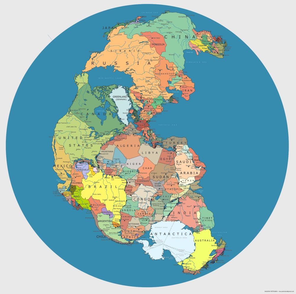
What the western US looked like then:  Something that isn't much talked about is the Fallout!www.thoughtco.com/nevada-silver-rush-1440699What isn't mentioned is that those beds of Silver Chloridee are laying on Devonian sediment!  What was that asteroid made of? We know the entire asteroid vaporized along with a huge amount of salty sea water and some ocean bottom. Those heavy vapors mixed, solidified, and fell. BTW, As the Farallon plate worked under Nevada it generated hot water that dissolved some of that Silver Chloride, sent it up the Hurricane Fault, and into the Silver Reef (just north of St. George Utah) Sandstone to puzzle later miners. www.mindat.org/article.php/1114/Silver+Reef%2CUtah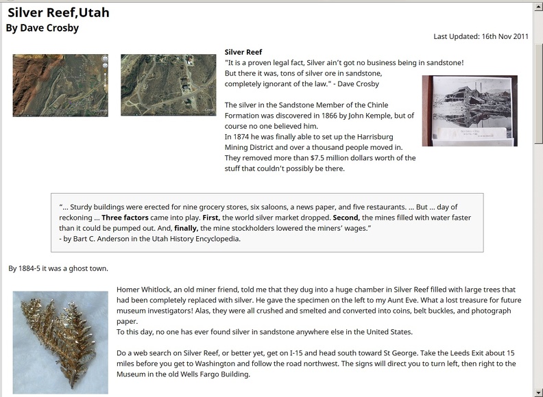 forum.rocktumblinghobby.com/thread/86450/silver-reef-southwest-utah forum.rocktumblinghobby.com/thread/86450/silver-reef-southwest-utah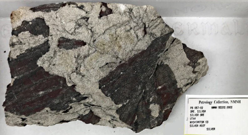 Perhaps this impact helped drive North America into Europe, creating our eastern mountains. Pangaea  Pangaea or Pangea was a supercontinent that existed during the late Paleozoic and early Mesozoic eras. It assembled from earlier continental units approximately 335 million years ago, and it began to break apart about 175 million years ago. |
|
|
|
Post by 1dave on Dec 19, 2019 23:12:40 GMT -5
250 million years ago Permian time ended with the greatest extinction period of all time.
A huge asteroid smashed into Wilkes Land, Antarctica, creating a crater 480-500 km in diameter. The Siberian Traps began in Siberia, Russia. The massive eruptive event which formed the traps, one of the largest known volcanic events of the last 500 million years of Earth's geological history, continued for a million years, starting Triassic Time. 225 Ma - Shinarump, just below the Chinle formation, was formed. 50 to 200 feet in thickness, stretching from Nevada, across Utah, Arizona, New Mexico, and into Texas; it consists of battered bits of; sandstone, mudstone, and broken chunks of petrified wood.
IMO This was formed by a Tsunami when the Farallon Plate buckled as it moved east and North America began moving west. 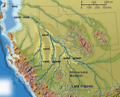 215 Ma - Chinle, 215 Ma - Chinle, of which the Petrified Forest National Park in Arizona is just a tiny part, was formed. Again in My opinion, during those ash-fall layers, several more tsunamis followed, ripping out huge trees, burying them and animals from Nevada to Texas. 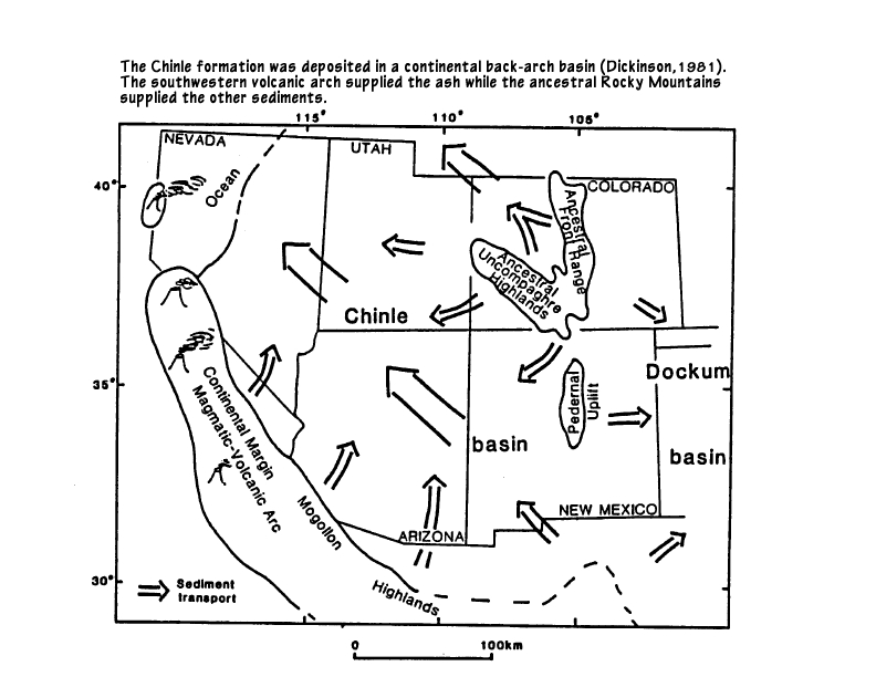 Read more: forum.rocktumblinghobby.com/thread/64569/petrified-wood#ixzz6865tHeq4200 million years ago Triassic Time ended when the Great Meteor (New England) Hot Spot began. “In the Atlantic, one of the longest hot spot tracks is the Great Meteor, or New England hot spot, located at 28ºW, 33ºN. It formed the New England seamount chain and the magma intrusions of the White Mountains. Two hundred million years ago (early Mesozoic age), just as the Atlantic was beginning to form, the area northwest of Hudson Bay was over the Great Meteor hot spot. Fifty million years later, as the Atlantic opened slightly, the hot spot track was under present-day Ontario. By 124 to 100 million years ago, the continental area of New Hampshire pushed over the hot spot, and the magma intrusions formed the White Mountains. Finally, between 100 and 80 million years ago, the hot spot formed the New England seamount chain. Bear Seamount—the oldest—formed about 100 to 103 million years ago. Moving southeasterly along the chain, the seamounts get progressively younger, with the Nashville Seamount being about 83 million years old. During the formation of the New England Seamount chain, the oceanic crust (itself only 120 to 80 million years old) pushes over the hot spot at a rate of about 4.7 cm per year. Finally, 80 million years ago, the mid-Atlantic Ridge migrated to the west over the plume. The track of this hot spot then continues on the African Plate and is found today at the Great Meteor Seamount.” oceanexplorer.noaa.gov/explorations/03mountains/background/geology/geology.html200 Ma Central Atlantic Magmatic Province (CAMP) Location of large residual elements of the Central Atlantic magmatic province en.wikipedia.org/wiki/File:CAMP_Magmatism_in_the_context_of_Pangea.jpgThe Central Atlantic magmatic province (CAMP) is a large connected magma flow that formed during the breakup of Pangaea in the Mesozoic Era, near the end of the Triassic and the beginning of the Jurassic. The breakup of Pangaea formed the Atlantic Ocean and provided a heritage of basaltic dikes, sills, and lavas over a vast area around the present central North Atlantic Ocean as well as large deposits in northwest Africa, southwest Europe, as well as northeast South and southeast North America (found as continental thoeliitic basalts in subaerial flows and intrusive bodies). The CAMP volcanic eruptions occurred about 200 million years ago and split into four pulses lasting for over ~600,000 years. The resulting large igneous province is, in area covered, the most extensive on earth. The volume of magma flow of ~2–3 × 10⁶ km3 makes it one of the most voluminous as well. This geologic event is associated with the Triassic–Jurassic extinction event.  200 Ma |
|
|
|
Post by 1dave on Dec 20, 2019 10:30:45 GMT -5
This is an interesting image: There has been a lot of studies about the northwest - Siletzia smacking into Oregon, down to the Richardson Ranch in Madras and on to Yellowstone, but little is recorded of the Farallon plate creating the California Costal range 200 Mya, The Cascades, various eruptions in Nevada, Utah and Arizona, nd finally into New Mexico. Some information is here: U.S. Volcanoes |
|
cosmetal
starting to spend too much on rocks
 
Member since September 2018
Posts: 115
|
Post by cosmetal on Dec 20, 2019 12:47:06 GMT -5
1dave Very interesting posts. But, I have to dispute the ThoughtCo statement: "In the California gold rush, like those before and after, the Forty-Niners swarmed into the land and panned the easy nuggets from the stream placers. Then the geologic pros moved in to finish the job." The "job" still isn't done. Many estimate that 90% of CA's gold still remains. The CA Geological Survey in their Note 12 Note 12"In 2001, California ranked fourth in the United States in gold production. Approximately 449,200 troy ounces were produced worth about $122.3 million." In the early to mid-70's. I held 4 BLM registered placer claims in Northern CA. I did everything by the "book". I had CA Fish and Game Suction Dredging and Stream Alteration Permits (I would use a powered wench to drag boulders along the bedrock). I found a lot of placer gold that had weathered out of exposed hard rock veins and tertiary gravels (research the "Big Blue Lead") The Great Blue Lead A lot of hard work but I will never forget watching the gold go into my suction nozzle and picking the nuggets out of cracks in the bedrock - yum! Unfortunately, those days are long gone. Currently, in CA, you can't suction dredge (legally) and can only use a gold pan (Hah! Good luck!) to remove placer gold. Peace, James |
|
Deleted
Deleted Member
Member since January 1970
Posts: 0
|
Post by Deleted on Dec 20, 2019 13:56:15 GMT -5
Hey, According to the map, I'm on the border of andesite and basalt - yep, that's what my shovel tells me whenever I try to dig a planting hole more than 6" deep out in the yard  |
|
|
|
Post by 1dave on Dec 21, 2019 8:43:17 GMT -5
1dave Very interesting posts. But, I have to dispute the ThoughtCo statement: "In the California gold rush, like those before and after, the Forty-Niners swarmed into the land and panned the easy nuggets from the stream placers. Then the geologic pros moved in to finish the job." The "job" still isn't done. Many estimate that 90% of CA's gold still remains. The CA Geological Survey in their Note 12 Note 12"In 2001, California ranked fourth in the United States in gold production. Approximately 449,200 troy ounces were produced worth about $122.3 million." In the early to mid-70's. I held 4 BLM registered placer claims in Northern CA. I did everything by the "book". I had CA Fish and Game Suction Dredging and Stream Alteration Permits (I would use a powered wench to drag boulders along the bedrock). I found a lot of placer gold that had weathered out of exposed hard rock veins and tertiary gravels (research the "Big Blue Lead") The Great Blue Lead A lot of hard work but I will never forget watching the gold go into my suction nozzle and picking the nuggets out of cracks in the bedrock - yum! Unfortunately, those days are long gone. Currently, in CA, you can't suction dredge (legally) and can only use a gold pan (Hah! Good luck!) to remove placer gold. Peace, James Thanks for sharing this! www.mindat.org/loc-209647.html |
|
cosmetal
starting to spend too much on rocks
 
Member since September 2018
Posts: 115
|
Post by cosmetal on Dec 21, 2019 12:31:41 GMT -5
1dave
Thanks for the very accurate reference from Mindat.org
I lived in Placerville for the 7 years that I was active on the South Fork of the American River and Rock Creek where my claims were located.
We never panned out our dredge's concentrate at the sites. We would take the "pickers" out of the first riffles and save the rest for winter. I built a 2'x8' water/gravity concentrate table (aka Miller Table) in my garage and we ran the "smalls-cons" over that.
We weren't "big time". We had two dredges, a 2 1/2" and a custom built 4". The key was a custom built power wench which we chain anchored along the shore. Had to hit bed rock or the pay-out wasn't worth the effort. We would spend 3/4 of our time hooking chain nets and rock slings to the boulders and dragging them on the way to bed rock.
Wish I had kept all the black sand cons from that table discharge. Amazing the amount of "micro gold" left in them.
Peace,
James
|
|
 Nov 12, 2024 9:54:37 GMT -5
 Nov 12, 2024 9:54:37 GMT -5
 Nov 14, 2024 18:17:57 GMT -5
*
 Nov 14, 2024 18:17:57 GMT -5
*
 Nov 15, 2024 17:44:51 GMT -5
 Nov 15, 2024 17:44:51 GMT -5


 What was that asteroid made of?


