|
|
Post by fernwood on Dec 25, 2019 7:17:00 GMT -5
Nat Geo has a web sight where you can select and download free PDF topo maps. I just tried it. Very high quality and learned a lot about my land. Knew there was some elevation change, but did not know it was almost 200'. You can also zoom in on specific areas within the selected quad. Great for determining potential rock locations. Or to be prepared for elevation changes when rock hunting. I hope to be able to convert the PDF I downloaded to jpg and post a photo. www.natgeomaps.com/trail-maps/pdf-quads |
|
|
|
Post by fernwood on Dec 25, 2019 7:27:01 GMT -5
Discovered a problem with converting the PDF to JPG. My property is divided in half between two quads.
Will need to spend some time on this, but I should be able to merge the two quads into one map. Then cut the section of my property out. Then save as a JPG.
|
|
|
|
Post by fernwood on Dec 26, 2019 5:35:22 GMT -5
Here is a small section of the topo map. My place is outlined. For being located in what is called the Driftless Area (which is known for being very flat), there are many elevation changes. I started becoming interested in topo maps in the 1970's. A person can learn so much from them. I was impressed with how this JPG turned out. Ended up just zooming in on the PDF. Then hitting Print Screen. Pasted the image into PSE. 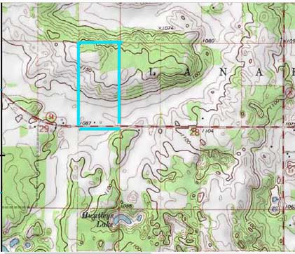 |
|
|
|
Post by fernwood on Dec 26, 2019 5:52:34 GMT -5
Here is a screen shot of the full map. 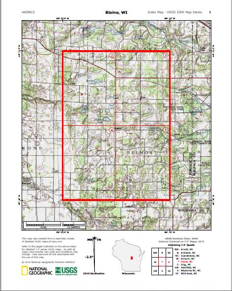 |
|
whyofquartz
spending too much on rocks
 So, Africa is smaller than I expected...
Member since December 2019
Posts: 318
|
Post by whyofquartz on Dec 26, 2019 13:14:52 GMT -5
|
|
EricD
Cave Dweller  High in the Mountains
Member since November 2019
Posts: 1,142
|
Post by EricD on Dec 27, 2019 12:34:07 GMT -5
I use the app LandGlide for topo, parcel boundaries, and ownership info to make sure I'm not pilfering rocks from where I shouldn't be. It's free, it's scrollable, and you can use your devices GPS location to see where you're at on the property. It has standard map, satellite, and topographic basemaps
Edit: Whoa nellie! I didn't see it was just a free trial. I won't be paying 10 bucks a month for it!
|
|
EricD
Cave Dweller
High in the Mountains
Member since November 2019
Posts: 1,142
|
Post by EricD on Jan 30, 2020 9:55:36 GMT -5
Check out the Landgrid Map and Survey Property app by Loveland Technologies. It's free and very comparable to Landglide.
No topographic base maps, but it does have street and satellite base maps.
|
|


