RWA3006
Cave Dweller 
Member since March 2009
Posts: 4,240 
|
Post by RWA3006 on Jun 17, 2022 11:00:15 GMT -5
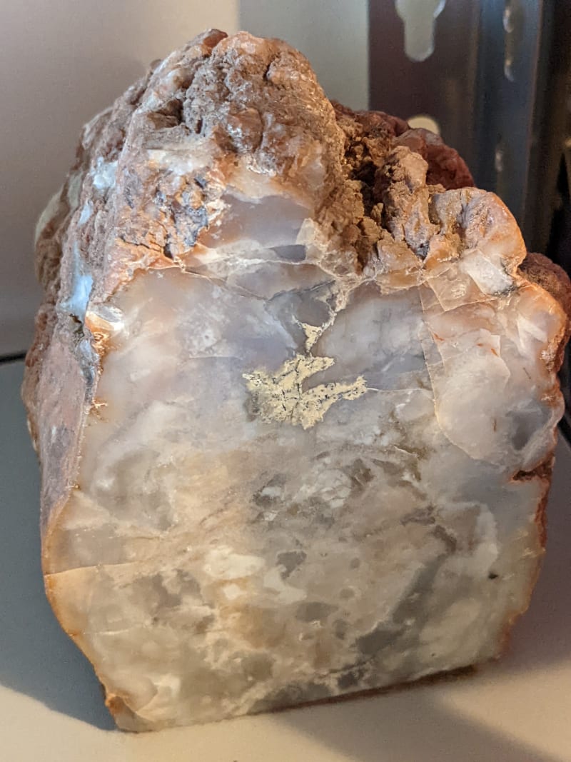
Love that agate at about 2:00 in the second picture. Beautiful colors. I do too, and it has fortification lines that are subtle enough that it's hard to see in the photo. I believe places like this were voids in the original turd that were later filled with agate. |
|
RWA3006
Cave Dweller
Member since March 2009
Posts: 4,240
|
Post by RWA3006 on Jun 18, 2022 8:56:58 GMT -5
|
|
RWA3006
Cave Dweller
Member since March 2009
Posts: 4,240
|
Post by RWA3006 on Jun 18, 2022 9:06:35 GMT -5
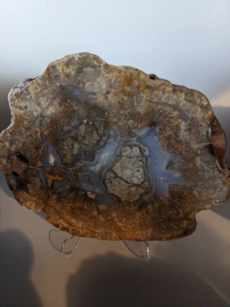
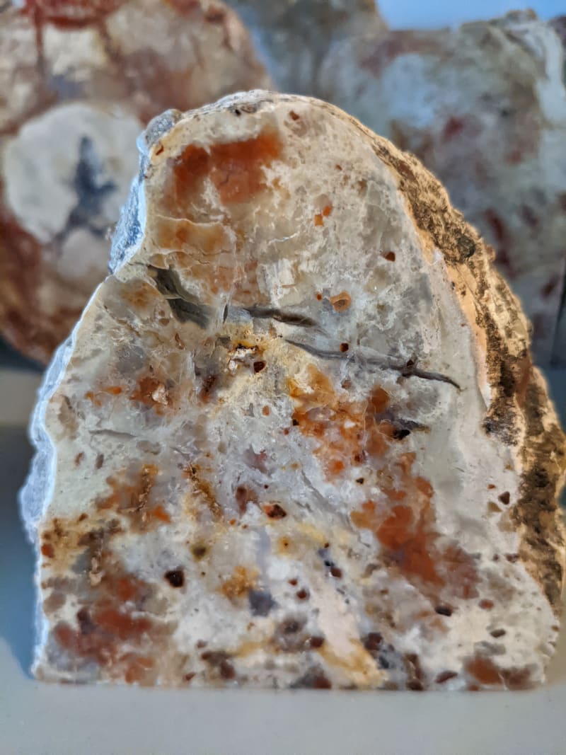
In the last four photos I've posted there's an anomaly near the center of the specimen. So far I haven't been able to figure out what they are and I'm at the point where I wish one of you smart people would just tell me! I'm thinking it's some kind of foreign object having to do with beetle activity and have ruled out gastroliths because the outer surface is not rounded.
Any ideas?
|
|
|
|
Post by 1dave on Jun 18, 2022 12:34:08 GMT -5
Is the bottom one bone chips? It may have had flesh around it that decayed.
|
|
RWA3006
Cave Dweller
Member since March 2009
Posts: 4,240
|
Post by RWA3006 on Jun 18, 2022 12:47:04 GMT -5
Is the bottom one bone chips? It may have had flesh around it that decayed. I really don't know, Dave. Maybe I need to get out the microscope and search it for bone cells or other clues. The only things I feel certain about the bottom photo are there's a smattering of red jasper micro gastroliths on the perimeter from two to four o'clock, and at about four o'clock there's a typical trace of beetle presence. |
|
RWA3006
Cave Dweller
Member since March 2009
Posts: 4,240
|
Post by RWA3006 on Jun 20, 2022 8:28:43 GMT -5
|
|
|
|
Post by 1dave on Jun 20, 2022 11:24:29 GMT -5
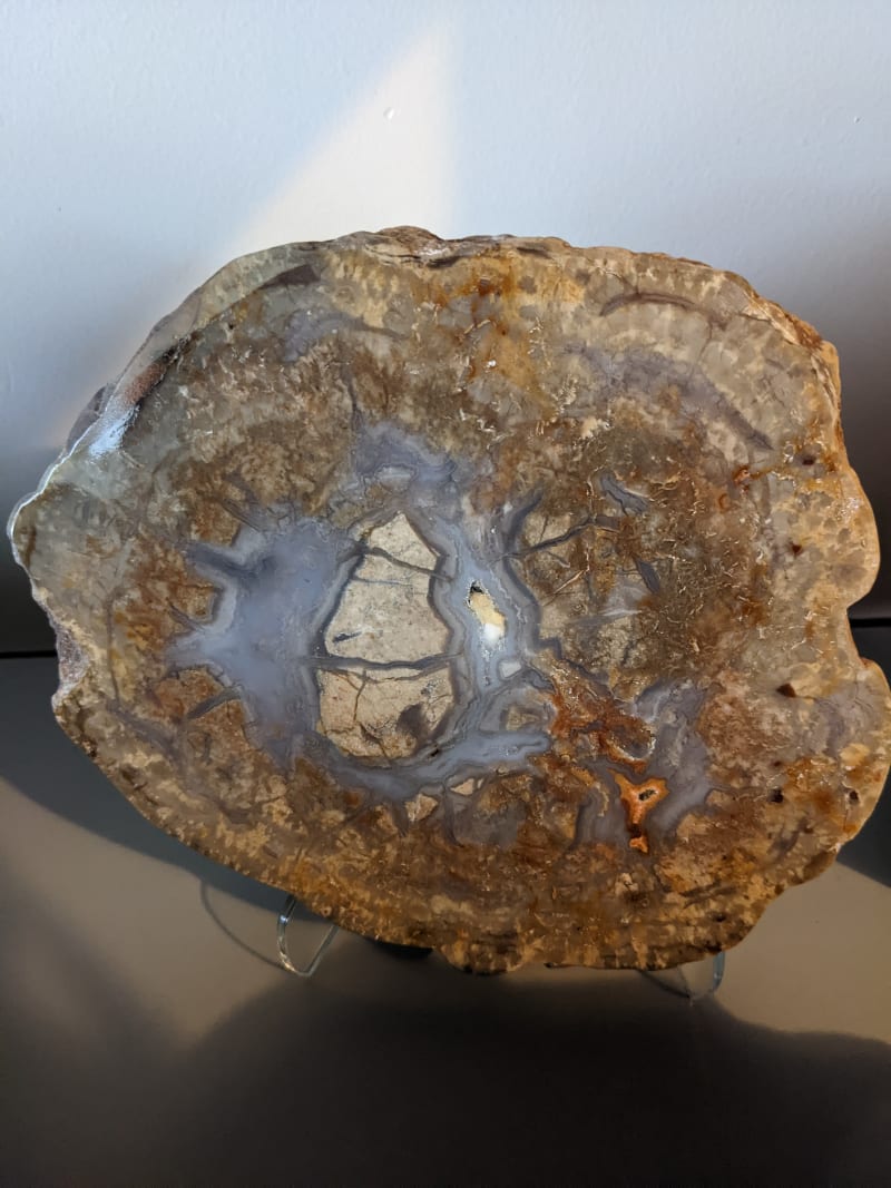
I think this is the end of a long bone, th flesh surrounding it decayed, providing the space that filled with agate. 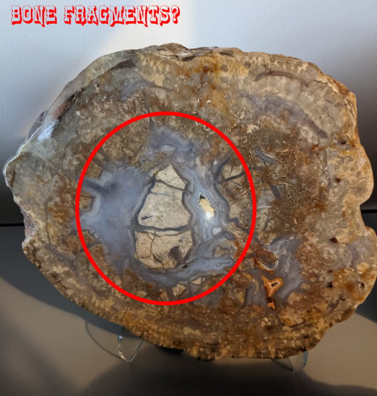 |
|
RWA3006
Cave Dweller
Member since March 2009
Posts: 4,240
|
Post by RWA3006 on Jun 20, 2022 11:49:06 GMT -5
I think this is the end of a long bone, th flesh surrounding it decayed, providing the space that filled with agate. Guess I should have it tested for phosphorus. I really don't know what to think, but it must be something odd because it's not some random occurrence. I know these sauropods ingested incidental objects and even the vegetarian variety supplemented the diet with mollusks. |
|
RWA3006
Cave Dweller
Member since March 2009
Posts: 4,240
|
Post by RWA3006 on Jun 21, 2022 8:38:50 GMT -5
TURD TUESDAY 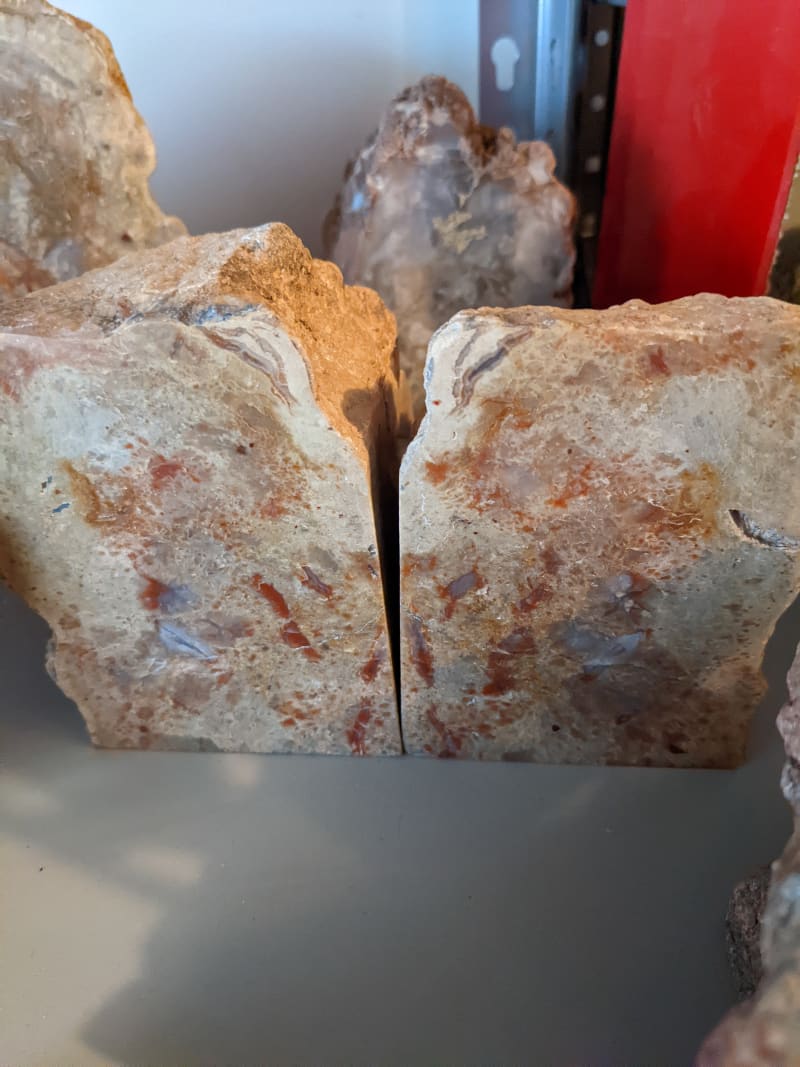 |
|
RWA3006
Cave Dweller
Member since March 2009
Posts: 4,240
|
Post by RWA3006 on Jun 23, 2022 9:13:42 GMT -5
|
|
|
|
Post by 1dave on Jun 23, 2022 9:26:39 GMT -5
Randy HERE is a look at your OLD hunting grounds: An Imaginary Journey into Utah’s Geological Past - By Thomas C. Chidsey, Jr. geology.utah.gov/map-pub/survey-notes/core-center-news/ferron_ss_cores_teaching/Take a drive about 70 miles south of Price through the arid Castle Valley in east-central Utah. Then imagine you are on a huge river delta with swamps and marshes of lush vegetation similar to the Mississippi Delta. Silt- and sand-laden streams and rivers meander through the area flowing east to a nearby sea that stretches east as far as Kansas. To the west lies a towering, north-south-trending mountain range (the Sevier orogenic belt)—the source for the sediments that the river system used to form the delta you are on. Dinosaurs are roaming around and reptiles fly in the sky. This is what east-central Utah looked like around 94 to 86 million years ago during the Late Cretaceous Epoch. 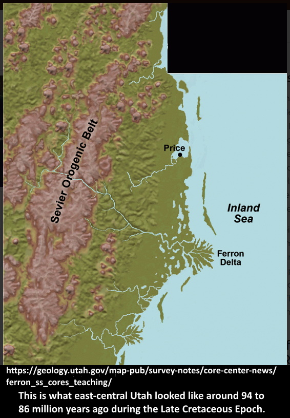 This ancient delta’s streams and rivers deposited their loads of sand and silt as point bars, levees, and channel fills where the rivers met the sea or along beaches, barrier islands, and in tidal inlets. Mud accumulated in bays, lagoons, and farther offshore, whereas vegetation in swamps piled up to form peat bogs. Eventually, the sea retreated and environmental conditions changed. The delta was buried by over 8000 feet of sedimentary rocks. Then regional uplift began about 70 million years ago exposing these rocks to the forces of erosion. The Ferron Sandstone— Analog for River-Dominated Deltaic Oil and Gas Reservoirs Worldwide Rapid erosion of the Colorado Plateau by the Colorado River and its tributaries over the last 5 million years and continued uplift have, once again, revealed the ancient river delta, which is now beautifully displayed along the west flank of the San Rafael Swell in the rocks known as the Ferron Sandstone—one of the most extensively studied cliffy exposures of rock in Utah. Why is the Ferron so important to geologists? It shows, spectacularly, vertical and lateral changes (the exposed rock belt extends northeast-southwest for over 80 miles) in the deltaic deposits, which serve as a visual analog for similar rocks that produce nearly half the world’s oil and gas hidden deep below the surface. Examples are found in the U.S. Gulf Coast, Alaska, North Sea, and Utah’s own Uinta Basin fields. The earliest Ferron Sandstone study goes back to 1874, to investigate coal resources in the area. Well over one hundred years and many studies later, the UGS conducted its own major investigation of the Ferron in the 1990s. The project involved two oil companies, three local universities (professors and students from the University of Utah, Brigham Young University, and Utah State University), and several consulting geologists. The goals of the project were to provide petroleum companies better tools and models to apply to their own oil and gas fields, as well as exploration efforts, using the Ferron rock exposures as examples. A major question, however, was what did the Ferron look like in the subsurface beyond the outcrop cliff face—a critical factor in predicting changes in the rocks in three dimensions. To answer that question, the UGS drilled four core holes and acquired, through donation, five more rock cores collected from shallow wells immediately west of the outcrop belt. These rock cores proved invaluable to the study, which resulted in over fifteen scientific publications. UGS Ferron Core Workshops for Students and Industry Professionals The UGS collection of Ferron Sandstone cores stored at the UCRC continues to be invaluable as training materials for students and industry professionals. After the cores were drilled, they were slabbed (cut in half) to remarkably reveal the various rock types and depositional environments seen in the Ferron outcrops—sandstone beds, representing river channels, sand bars, and beaches; siltstone and shale containing shells and burrows of marine and brackish water organisms that lived offshore or in bays; and coalbeds that formed from vegetation in swamps and peat bogs. The cores also show rock boundaries indicating times with major changes in sea level, critical information when developing oil and gas fields or exploring for new ones. The cores also provide information about oil and gas reservoir quality (pores in the rocks capable of storing hydrocarbons and permeability— the connection between those pores that permits fluids to flow within the rock to a wellbore). Such descriptive reservoir characteristics can be applied to oil and gas exploration and development of similar ancient delta deposits throughout the world. The UGS annually hosts or conducts numerous workshops (and companion field trips) using the Ferron cores for educational and industry training. Local universities regularly bring their geology students to the UCRC for Ferron core classes. Attendees of UGS-sponsored and industry training groups have come from all over the U.S., as well as Great Britain, Norway, Ireland, France, Argentina, China, and Indonesia, and researchers continue to use the Ferron cores for new studies. Someone once said, “Oil is not found in the ground, it is found in the minds of geologists!” Geologists, both students and professionals, use their minds to better understand the geologic past and imagine where to find oil and gas, employing tools such as the UGS core set and rock exposures of the Ferron Sandstone. To see the Ferron Sandstone core set or schedule a workshop at the UCRC, contact Peter Nielsen, Curator. Phone: 801-537-3359 • Email: peternielsen@utah.gov Survey Notes The Uinta Mountains: A Tale of Two Geographies GeoSights: Roosevelt Hot Springs Geothermal Area, Beaver County Core Center News: Ferron Sandstone Cores, Excellent Teaching Tools to Spark the Imagination! Glad You Asked: What are keeper potholes & how are they formed? Survey Notes PDF Survey Notes, v. 46 no. 3, September 2014 |
|
RWA3006
Cave Dweller
Member since March 2009
Posts: 4,240
|
Post by RWA3006 on Jun 23, 2022 10:21:14 GMT -5
Thanks for that 1daveThere's no question these old dinos were roaming beach front property back in the day. Every time I make a field trip I can see ample evidence of it such as old fossilized beaches contemporary with the coprolite and bone layers. Some of the best evidence is the presence of crustacean shells inside some coprolites. |
|
|
|
Post by RickB on Jun 23, 2022 12:47:37 GMT -5
Sphinc-tacular  |
|
|
|
Post by 1dave on Jun 24, 2022 1:06:40 GMT -5
The Wasatch Hinge Line has been there from Rodenia, the early super continent, to the present. 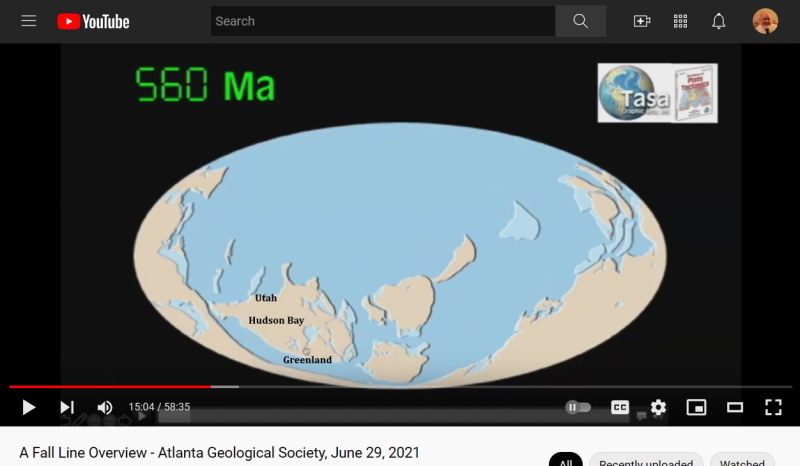 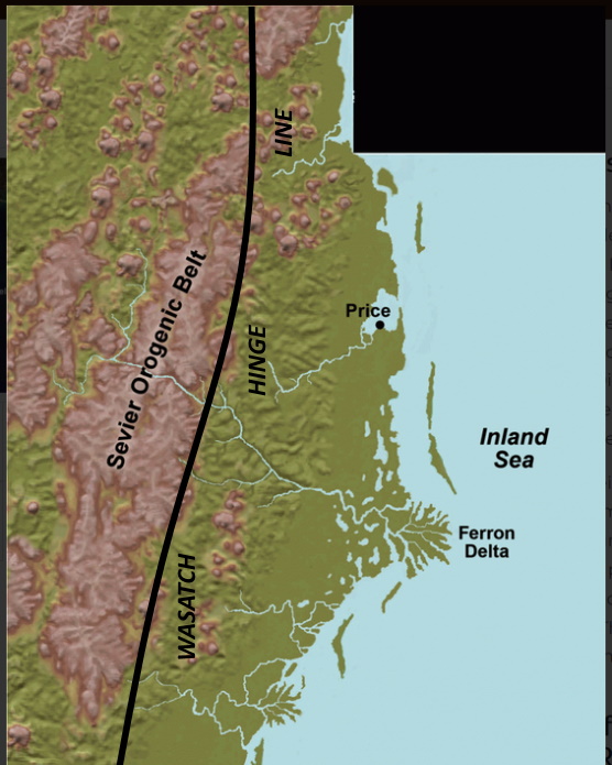 Breaking again on that line and being plunged down at the end of the Jurassic is what allowed the Inland Sea to come into existence. The Sevier (shallow horizontal NE > SW) and Laramide (deep W > E) Orogenies intertwined for a long time. Today the aftermath continues with America pulling ever farther from Europe, but the west is moving faster than the east! |
|
|
|
Post by 1dave on Jun 24, 2022 12:49:29 GMT -5
dawndinos.com/triassic-jurassic-period/ "Why did dinosaurs become so dominant across the Triassic-Jurassic boundary whilst the pseudosuchians were so decimated? From the Jurassic onwards, why did the crocodile lineage remain restricted mainly to amphibious quadrupeds, whilst the dinosaurs radiated into many sizes, forms and behaviours and even survived the end-Cretaceous extinction as birds? A hypothesis proposed back in the 1970s is that dinosaurs, even in the Triassic, had “locomotor superiority” over pseudosuchians and other land animals, based upon the anatomy of their hips and hindlimbs that might have given them better ability to run and execute other behaviours such as jumping. Our project aims to test this hypothesis by investigating how anatomy and locomotor abilities are (or are not) linked in disparate species of archosaurs." 
|
|
RWA3006
Cave Dweller
Member since March 2009
Posts: 4,240
|
Post by RWA3006 on Jun 24, 2022 16:48:47 GMT -5
One thing's for sure... A lot of water has run under the bridge before our time. Wish I had witnessed it all.
|
|
|
|
Post by 1dave on Jun 24, 2022 18:07:10 GMT -5
|
|
RWA3006
Cave Dweller
Member since March 2009
Posts: 4,240
|
Post by RWA3006 on Jun 25, 2022 10:31:41 GMT -5
Here's a strange one. 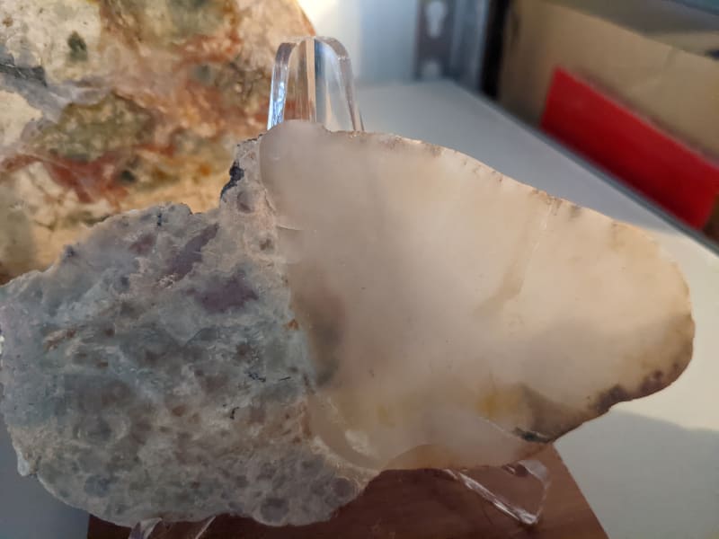 |
|
|
|
Post by 1dave on Jun 25, 2022 12:08:23 GMT -5
Petrified by BLANDITE?
|
|
|
|
Post by RickB on Jun 25, 2022 12:45:49 GMT -5
Very nice. It looks like Mr. Hadrosaur crapped on an agate.
|
|


 Drifting along with the tumblin' tumbleweeds