jamesp
Cave Dweller 
Member since October 2012
Posts: 36,602
|
Post by jamesp on May 25, 2014 19:52:31 GMT -5
Seems that the western ancients were quite progressive forward thinkers.these are fairly recent peoples at 1000 years ago.
Most of the points we find are 3000-7000(archaic era). I think point manufacture slowed down as agriculture was started
in the 1000 year ago range Ed. Still blows my mind that we find points 80 miles out in the ocean from when the ice age sucked
up all the water. They are always old points. Also on the bottom of the Suwanee River. It was a mere trickle during the ice age and
is loaded with paleo camp sites on the bottom of the river. A pale point is only found at a rate of 1 per 3-400 later points. I think we
have found 3 in 30 years. However, those that hunt Florida's Suwannee and Santa Fe river find them quite frequently. Further proof
of the ice age. and those dudes wrestled with mastadons. Imagine going to war w/that monster. Apparently they dug a hole next to
it and built a huge fire and developed embers before rolling the beast into the hole. Skeletal scratches revealing those guys tunneled thru the meat
to 'harvest'. Talk about a big roast.
|
|
|
|
Post by mohs on May 25, 2014 22:15:41 GMT -5
Interstering James how much evidence of earlier settlement In your area then you’ll find in the desert area. It must be a matter of water. Certainly smaller tribes were in the desert vicinity thousands of years ago; but large settlements are few and far between You’ll notice on the map an area called Papago. Its park now. But the red sedimentary hills are mystery to an extent. Where’d they come from? One theory posits that a massive mud slide occurred from the higher elevation an inundated the valley. Creating the red hills of Papago. The picture is just small representation but chose for the red color. This is why Phoenix is such a soil rich valley and all the rocks are covered over!  Another theory posits that the Papago Buttes were deposited by a shower of meteors. Debris! And meteoric activity occurred just a scant 500 years ago. Just before Coronado explored this region in 1540. How does the author justify this theory? Because the author claims that the, ‘Seven Cities of Cibola’ that Coronado was seeking-- was actually found! And where was it found? None other than-- the Hohokam settlement on the map. But the Indian were gone. All Coronado found were the ruins. What happened to the inhabitants? T he author contends that the meteor deposits that created those Papago's dried up the Salt River. Actually it diverted the river path and dried up the canals. This drought forced the Hohokam to abandoned their site. So what happened to the gold? That a later story Indeed! |
|
jamesp
Cave Dweller 
Member since October 2012
Posts: 36,602
|
Post by jamesp on May 26, 2014 7:41:10 GMT -5
Water is most important.
In the Ocala National Forest there is little water over large areas. But there are large springs. The springs were mega camps.
in the north Georgia mountains the few bottom lands along the creeks and rivers were rich and flat, also served as mega camps.
Any small creek with a flat spot just above flood height in the piedmont is high chance of being a camp.
Any spring boiling out of the ground w/fresh drinkable water has potential.
The most desirable water source is the mega springs in Florida. Most are well over a million gallons a day. So pollution is taken away.
They have an infinite source of bathing, drinking, butchering and whatever at their disposal. At 72F. In a hot miserable enviro.
They were able to stay at these camps free of disease and septic issues for many years. Remember Ponce de Leon and the fountain of youth ?
The geological activity you mentioned, meteor or slide deposits ? Rich soil is a big resource. Many cities were settled because of ancient people
had found good soil and water. Never knew Phoenix may have had such influence. Makes for easy development, rocks do get in the way.
Losing the water makes canals useless. In a many crimes they follow the money trail. Ancient civilizations... follow the water trail.
Out west you guys have had a lot of recent geological activity. That may make things more complicated. Especially meteor strikes.
Would imagine that water sources in the desert were big attractants. Cold country has clean water in the form of ice making access to water easy.
Here in the south, deforested areas were suspect as being sites for modern cities. The trees were probably girdled a generation before and left to rot.
So the next generation would have a clearing. Again, those clearings were chosen for good water supplies.
|
|
jamesp
Cave Dweller 
Member since October 2012
Posts: 36,602
|
Post by jamesp on May 26, 2014 7:58:57 GMT -5
Wetumpka Alabama meteor site. This was a big one Ed. The ridge around the crater has sedimentary deposits capping it. River rocks sitting on top of the hill ! Gravel companies mine the round gravel pebbles. Removing river gravel from rivers has about been outlawed around here due to environmental damage. They are certain this was a meteor strike. I believe it came in from the west(left side of photo) making a horse shoe shape. See the roads on top, right and bottom side of the impact. They are on the crater ridge/rim. Looks like the river got diverted around the rim too. Maybe the Hohokam had built a giant rock launcher and sent that sucker over here...oh yea, crater about 5 miles across !  |
|
|
|
Post by mohs on May 26, 2014 15:17:11 GMT -5
interesting James!
You'll have to give me some time to give a thorough reply
I'm in the middle of serious flat lapping job!
plus I got the Salton sea treasure map to post
and Hohokam settlement pictures to find
busy finding lost rocks...mostly
|
|
|
|
Post by mohs on May 27, 2014 20:11:58 GMT -5
10 years ago when I copped this picture from a 1940’s rare treasure hunters book it was important to a discussion I was involved dealing with a lost ship in Salton Sea area. 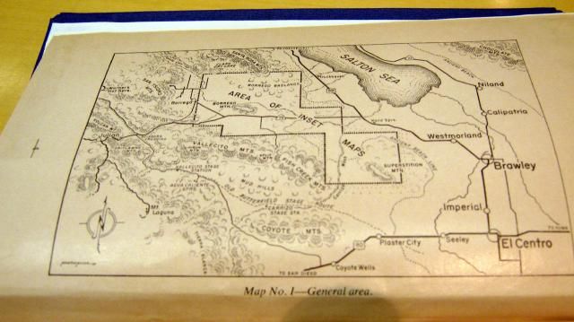 Now it just looks like a good map of the area Yet maybe some will recognize something? Especially a stranger who does a google search for “ lost ship of the Salton Sea” mostly |
|
|
|
Post by mohs on May 28, 2014 20:08:28 GMT -5
I love catching plane’s in flight This is one over the Hohokam museum Those structures are faithful reproductions 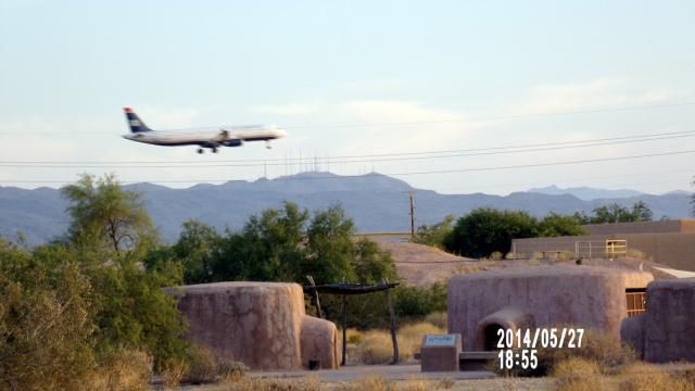 An ancient city with a jet overhead Imagine the history |
|
jamesp
Cave Dweller 
Member since October 2012
Posts: 36,602
|
Post by jamesp on May 28, 2014 21:28:46 GMT -5
|
|
|
|
Post by mohs on May 28, 2014 22:36:29 GMT -5
Thanks James
It not the best picture of the settlement
But in the back ground you'll notice
the mound the Hoho's built
It is greatly reduced now from weathering
It was humongous in its day.
Must have been 10‘ high
Not sure why Indian constructed mounds?
Lots of conjectures
But I believe the Hohokam did it for the most practical of reasons
To have height! Phoenix is pretty flat valley.
So from the main settlement they could get a good surrounding view.
Plus with all the other available mountains around
Papago, Camelback, South Mountain, Barnett hills
ect…. They could signal very easily.
Smok’n !
Anyway, they supposedly abandoned the site in 1450’s
They had a good 500 year run
Something happened around that time frame
The mound building Indians of the Midwest
also got spooked around that time frame
and changed their ways..
no one really knows, I guess….
|
|
jamesp
Cave Dweller 
Member since October 2012
Posts: 36,602
|
Post by jamesp on May 29, 2014 6:20:34 GMT -5
The whole concept of mounds is a mystery. Lots of theories. Like pyramids. I artifact hunt, but stay clear of mounds except one. It is a lump in a corn field
about 4 miles away. They plow on it and I surface collect the strange mound culture spearheads. Another mound a mile behind my house back in the woods. it
is undisturbed and I stay away from it. They are related to burials and I treat them as a cemetery. And that may be their purpose, to bury their leaders and their family.
However, the Etowah mound inhabitants seemed to have been involved in cruel sacrifices as circular burials of infants were found. And odd skeletal remains that seemed
beheaded. Many mounds in Florida and very few are over 5 feet tall. The ones at the large springs were the biggest. The Crystal River(FL) mounds were named after the amethyst
crystals that they collected from 3-400 miles away at closest. Ohio Mound culture is similar to Etowah and many other mound cultures in the south. Flint Ridge chert being found
all over the south in mounds. Flint Ridge chert had a lot to do w/figuring out trade routes.
Again, Bartram visited the Ocmulgee Mounds when they were occupied and may have recorded more historical info than anyone on the mound people. I think they figured
Etowah culture dissolved about 500 years ago for no good reason.
|
|
jamesp
Cave Dweller 
Member since October 2012
Posts: 36,602
|
Post by jamesp on May 29, 2014 6:48:37 GMT -5
You can see NW of Atlanta and along the St. John's River where my Florida camp is located (NE Florida) is peppered w/mounds. Even the river frontage of my Florida camp is over 2 feet deep in shell midden, probably a flattened shell mound when it was an orange orchard 100 years ago.  |
|
jamesp
Cave Dweller 
Member since October 2012
Posts: 36,602
|
Post by jamesp on May 29, 2014 6:50:58 GMT -5
Ohio mound distrubution. Wow  |
|
jamesp
Cave Dweller 
Member since October 2012
Posts: 36,602
|
Post by jamesp on May 29, 2014 6:55:41 GMT -5
I have found many mounds not on the map. Many. Especially in Florida.
|
|
grayfingers
Cave Dweller 
Member since November 2007
Posts: 4,575 
|
Post by grayfingers on May 29, 2014 8:07:13 GMT -5
I think they figured Etowah culture dissolved about 500 years ago for no good reason. Five hundred years. . . about the time the "native" peoples such as the Cherokee flourished in that area? |
|
jamesp
Cave Dweller 
Member since October 2012
Posts: 36,602
|
Post by jamesp on May 29, 2014 12:10:17 GMT -5
I think they figured Etowah culture dissolved about 500 years ago for no good reason. Five hundred years. . . about the time the "native" peoples such as the Cherokee flourished in that area? It is a difficult subject about Cherokee and Creek. I am not familiar w/their history because I do not spend time around mounds. I have found Mississippi aged culture points such as bird points. But they marched the native folks to Oklahoma and abused them into near extinction. They sent emails out west and the natives were waiting for whites arriving. Probably w/bows drawn. There are few reservations here. North Carolina near Cherokee. But Georgia may have nary a one. S. Florida and the mighty Seminoles has reservations. But early in American history eastern natives were killed off by disease and abuse. Wife is quarter Cherokee and mean as a snake. Most of the points I find are in small primitive camps much older than named natives I believe. We have many point types. Many camps have been occupied several thousand years. The archeologists dig them by layer and categorize point types. After 100's of such chronological categorizations they age the point types. Most of what i find is woodland-archaic, 1500-5000 years ago. The later Mississipi culture was more of a farmer and less of a point launcher. Again, William Bartram studied these people. Said he saw one shoot a rabbit from 30 paces with a tiny bow...in the eye. yo. And hired them as guides. And was not sure what their next move was. But was freaked out by their woodsman skills. Bartram will captivate, he got to see this place before it got altered. England hired him to record what he saw. and his biological were very accurate. So he says he saw 25 foot alligators, there is good theory that they can grow to whatever size, given enough years. I would guess that he was reporting accurately. He recorded the 'parti-colored' stone known asSavannah River agate. And the native's large quarry operations where they mined it. Crazy experiences he had. |
|
|
|
Post by mohs on May 29, 2014 20:58:54 GMT -5
Real interesting information James
Ya know the history and area excellently
What lost treasure legends are in your area?
I’ve read many account of the ‘fountain of youth’
Had you ever heard of the 3 Spaniards
that got shipped wrecked in Gulf Of Mexico and
walked across New Orleans, Texas, New Mexico, Arizona
eventually ending up in Mexico?
|
|
gemfeller
Cave Dweller 
Member since June 2011
Posts: 4,059 
|
Post by gemfeller on May 29, 2014 23:01:12 GMT -5
Wow, go out of town few days and miss a thread like this! This stuff really gets me going.
James, you are a man of many parts. Your information about the archaeological past of your region is fascinating to me. I've given that a lot of study, especially the Mississipian cultures at Cahokia and elsewhere. I believe the largest pyramid found so far North America, Monks Mound, is in Cahokia. It covers 16 acres and contains more material than the Khufu Pyramid, Egypt's largest.
Also, IIRC, some of the oldest human remains yet found in the U.S. came from some of those Florida springs you mentioned. I've downloaded Bartram's book but it's a ways down my immediate reading list. I'm anxious to get to it. Your wife out-Cherokee's me a little. I'm 1/16 and only as mean as a water snake (though from what I read here they can leave a nasty non-venomous bite). It's that English-Irish-Scots-Welsh-German part that gets me into trouble. Especially the Irish.
Ed, you live in a fascinating place and have lots of knowledge about its past. You mention a Hohokam ball court. Can you describe it? Does it appear similar to the Mayan ball courts? I ask because I've spent a bit of time tracing Mesoamerican and Mexican influences in what is now the U.S. I had a big surprise a few years ago when I visited Wupatki, east of Flagstaff (founded by the Sinagua, Cohonina, and Kayenta Anasazi) and found a miniature Mayan ball court. It appeared to be only ceremonial in nature (seemed too small for actual use). It was a fascinating link, in my mind, to trade routes and cultural diffusion from far to the south.
Another spot of great interest to me was Walnut Canyon not far from downtown Flagstaff. Those people were *scared* of something. If you haven't been there take a hike down into the canyon. It's absolutely amazing. I'm anxious to get back to AZ and explore many more of its world-class archaeological sites.
|
|
jamesp
Cave Dweller 
Member since October 2012
Posts: 36,602
|
Post by jamesp on May 30, 2014 20:15:31 GMT -5
I have hunted points for many years, and make an effort at most clearings.
The topography is almost a dead ringer if you can see into the woods around creeks and rivers.
Funny, all the construction around Atlanta has been a big resource. If the site gets rain before they start deep grading.
Often, old homesites are also ancient camps. People used to build houses close to the same resources as native man.
|
|
|
|
Post by mohs on May 30, 2014 21:19:19 GMT -5
Construction site in the Phoenix area will STOP
if they unearth a burial or artifacts.
There is a procedure with the local Indian council
that as to occur. It happens all the time.
I would say Phoenix, as done a good job
cataloguing & archiving sites.
That may not be an opinion shared by all
|
|
|
|
Post by mohs on May 30, 2014 21:20:53 GMT -5
Here are some pictures from today’s Casa Grande Ruin tour I got there later than expected The sun was radiating hot So it was short tour Plus the museum was closed They’re installing an air conditioning system About time! But the Casa Grande Ruins were a bit of anomaly as far as Hohokam settlements go. Their ball court was small compared to the one at Pueblo Grande. But there was couple of them about. 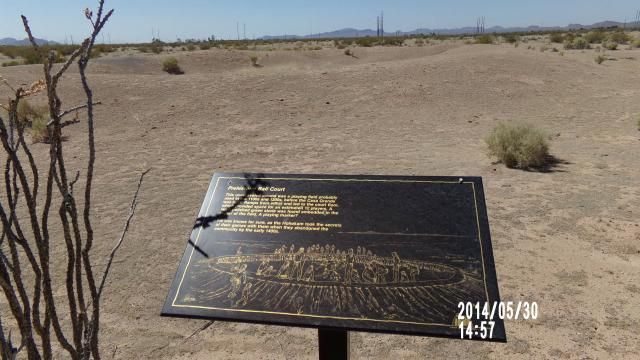 Plus there were a few mounds. Big! I took a picture but it just looks like a desert hill. So I haven’t edited yet, or too the time to upload it. Metate were left behind everywhere. The Hohokam really knew how to grind! 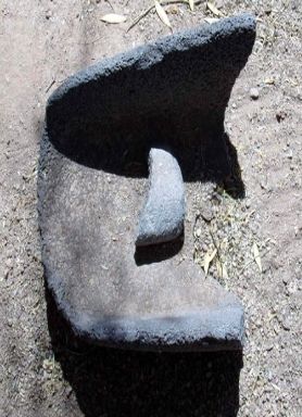 Notice how deep this one was. How many centuries was it used? How much basalt minerals were in the grain? Dear, this tortilla a little crunchier than usual.  And the Big House. 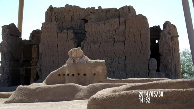 Not sure what the structure in the foreground was used for or its purpose? Maybe some one here does? |
|