Post by 1dave on Jun 22, 2017 3:53:26 GMT -5
Texas Geology Chart

Explanation

Geology Rock Column

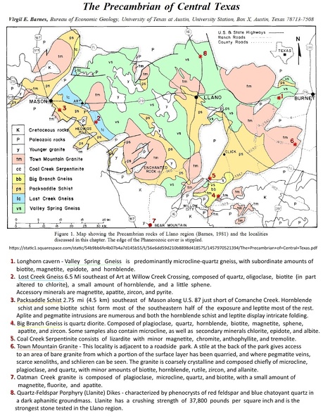
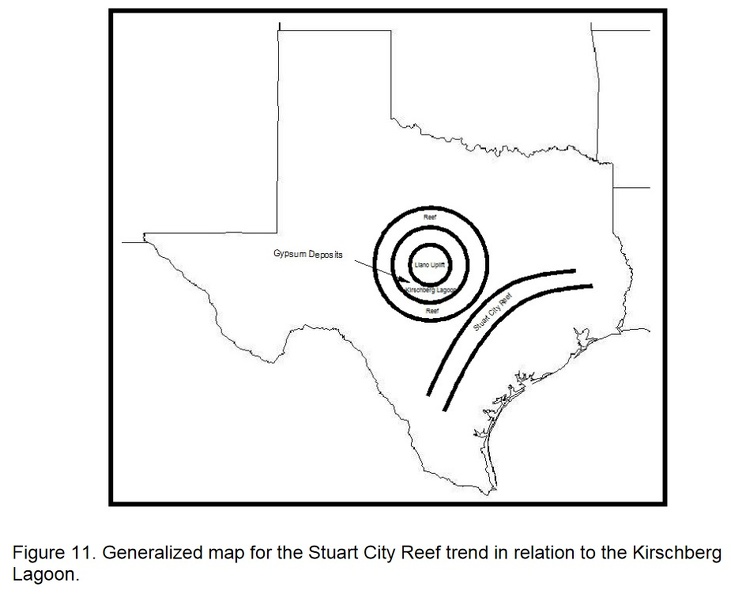
It is hard to see but in the center is the Llano Uplift.

en.wikipedia.org/wiki/Llano_Uplift


Town Mountain Granite up close.
the Town Mountain Granite(TMG)
Primary rock type - Granite:is precambrian coarse-grained, pink, quartz-plagioclase-microcline rock, in part porphyritic with large microcline phenocrysts. Occurs in plutons up to 13 mi in size that tend to be concordant circular vertical cylinders with concentric textural variaions; boundaries range from sharp and regular to highly irregular with wide zones of mixed rock. It is surrounded by a ring of gneiss and schist (Valley Spring gneiss and Packsaddle schist, respectively, also Precambrian), which is in turn surrounded by uplifted lower Paleozoic strata.
Secondary rock type - Porphyry

Few are aware of the Lone Star state's version of Lady Liberty.
This was my old stomping ground. We lived 4 blocks from the capitol building and as a brat, I was all over it, climbing the outside walls to get in the 2'nd floor windows, climbing the spiral staircase to get to the tip top overlook, to collecting spending money from the now long gone fish ponds.

Town Mountain Granite.

A major division of Texas Geology is the Ouachita Fold Belt.

1. Marfa Plume Agate
Lets start on the far left with the Marfa Basin. Who isn't fond of the Marfa Plume Agates?
Thank "Solitario" for them! -


2. Petrified Wood
Above and to the east, in the western Panhandle is the Chinle Petrified Wood - known here as "Docum."
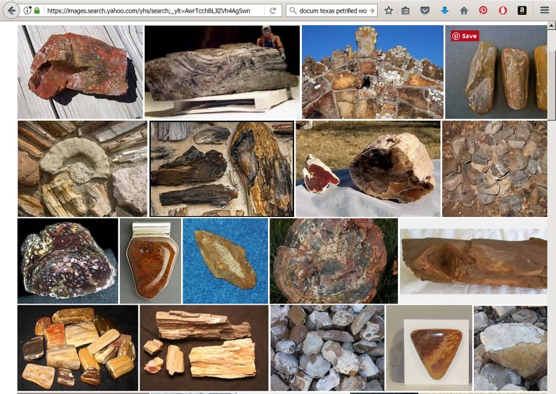
Petrified Palm Wood is the Texas State Rock
statesymbolsusa.org/symbol-official-item/texas/state-dinosaur-fossil-state-rock-mineral/petrified-palmwood
And other Pet wood is found in many parts of the state.
txpetrifiedwood.com/
www.miim.com/thebside/texas99/mville.html
3.Flint
Flint

4. Texas Topaz
Moving east into the staked Plains, how about some Texas Topaz! -Found weathering out of Pegmatites in Precambrian Rocks from Mason to Burnett
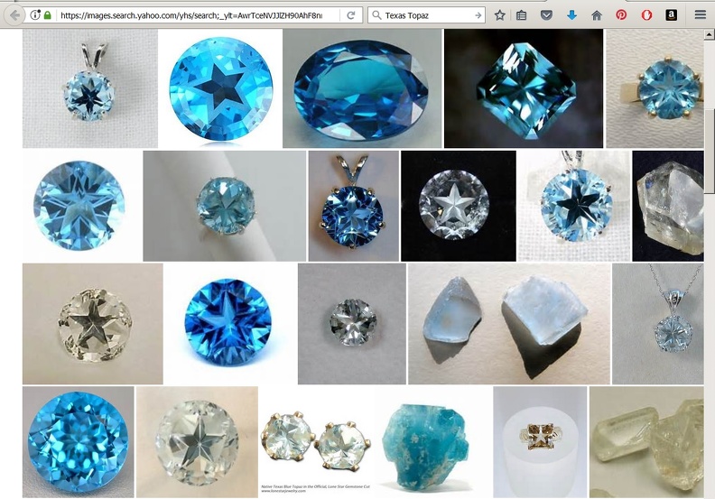
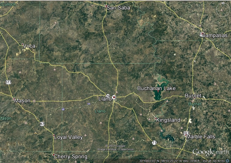
If you are going to search for Texas Topaz, it will help if you know what formations they will be found in.
Yeah, but . . . Where, what, how . . .
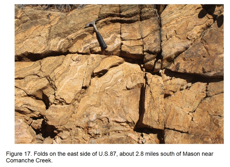
The first were found in creek beds like Comanche Creek, next to eroding Packsaddle schist folds that were formed way back when ancient North America slammed into Europe. Packsaddle and the surrounding Valley Spring Gneiss and Town Mountain granite were later intruded by pegmatites where penetrating fluorine gas transformed silicon and aluminum into topaz - a silicate mineral of aluminum and fluorine with the chemical formula Al2SiO4(F,OH)2.
Packsaddle Schist
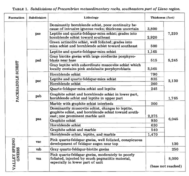
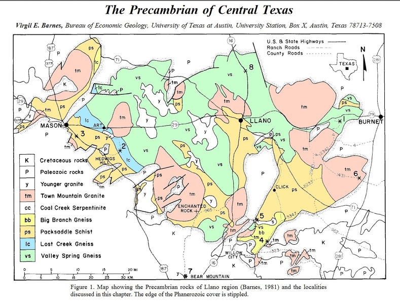
PS in gold = Packsaddle Schist Locations.
So what does the "packsaddle" look like?
The next two images are from
scholarworks.sfasu.edu/cgi/viewcontent.cgi?article=1001&context=geology

Blue Topaz is the Texas state gemstone as well as the birthstone for the month of November. Blue Topaz is the Texas state gemstone as well as the birthstone for the month of November. It occurs naturally in many colors including blue, orange, brown, green, pink, beige and red. Colorless topaz, a the most common variation, can be treated by irradiation to produce a wide range of shades of blue. Thus treated, blue topaz is one of the most popular and widely used of all gemstones.
Blue topaz was adopted as the state gemstone as the result of legislation approved March 26, 1969. The same legislation also named petrified palm wood as the state stone. It occurs naturally in many colors including blue, orange, brown, green, pink, beige and red. It is especially common in the East Texas Piney Woods region and along the Gulf Coast.
5. Rare Earth Minerals
Buchanan Lake is the site of a famous meteorite impact that provided lots of rare earth minerals. Probably used in making the first transistors.

6 Oil
Oil? - - - in Texas?


Explanation

Geology Rock Column

It is hard to see but in the center is the Llano Uplift.


en.wikipedia.org/wiki/Llano_Uplift
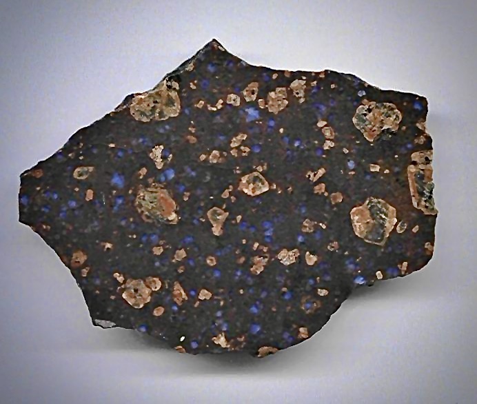
The Llano Uplift is a roughly circular geologic dome of Precambrian rock, primarily granite, in Central Texas in the United States. It is located in the eastern region of the Edwards Plateau and northern region of the Texas Hill Country. The region is characterized by a central exposure of Precambrian granite (Town Mountain granite), surrounded by a ring of gneiss and schist (Valley Spring gneiss and Packsaddle schist, respectively, also Precambrian), which is in turn surrounded by uplifted lower Paleozoic strata. This area is rimmed by limestone ridges.
The Llano Uplift is best known for its large, protruding rock formations, such as Enchanted Rock. The area includes several major quarries like Granite Mountain that mine the distinctive pink granite. Further, the area contains the only known deposits of llanite.
The Llano Uplift is best known for its large, protruding rock formations, such as Enchanted Rock. The area includes several major quarries like Granite Mountain that mine the distinctive pink granite. Further, the area contains the only known deposits of llanite.

Llanite is a hypabyssally intruded variety of rhyolite with phenocrysts of microcline and euhedral quartz. The quartz crystals are blue hexagonal bipyramids. The unusual blue coloration of the quartz is thought to be due to ilmenite inclusions.[1] It is named after Llano County, Texas, the only place where it is found (according to locals; however, geologists have identified other locations where this rock may be found, according to Robert Reed.)[2] A dike of llanite crops out on Texas State Highway 16 about 9 miles north of the town of Llano.[3] This sample was found near Llano Texas in 1981. Jerry Cooper


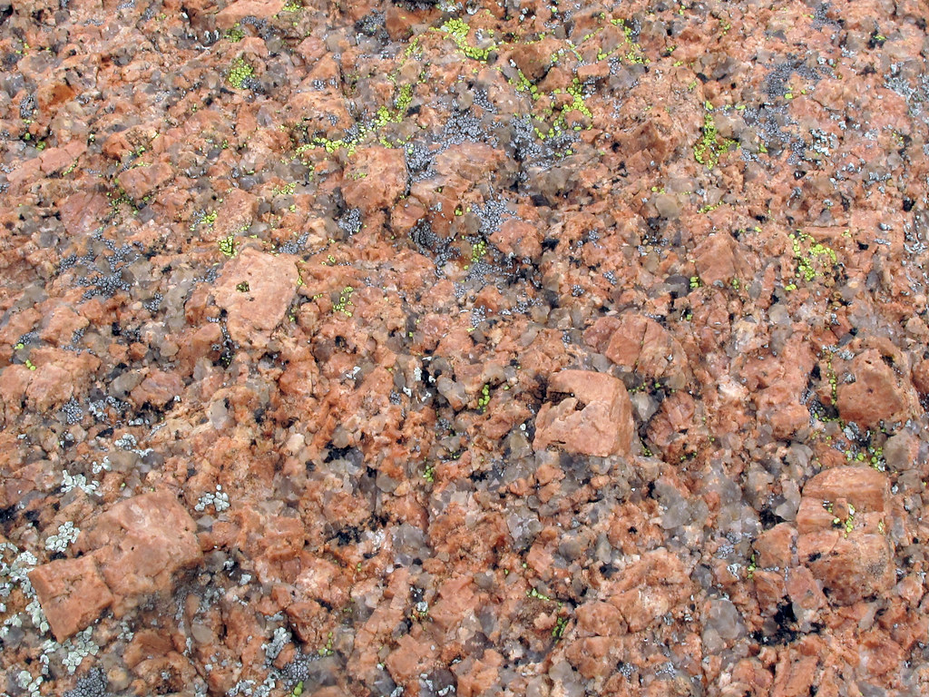
Town Mountain Granite up close.

the Town Mountain Granite(TMG)
Primary rock type - Granite:is precambrian coarse-grained, pink, quartz-plagioclase-microcline rock, in part porphyritic with large microcline phenocrysts. Occurs in plutons up to 13 mi in size that tend to be concordant circular vertical cylinders with concentric textural variaions; boundaries range from sharp and regular to highly irregular with wide zones of mixed rock. It is surrounded by a ring of gneiss and schist (Valley Spring gneiss and Packsaddle schist, respectively, also Precambrian), which is in turn surrounded by uplifted lower Paleozoic strata.
Secondary rock type - Porphyry

Few are aware of the Lone Star state's version of Lady Liberty.
This was my old stomping ground. We lived 4 blocks from the capitol building and as a brat, I was all over it, climbing the outside walls to get in the 2'nd floor windows, climbing the spiral staircase to get to the tip top overlook, to collecting spending money from the now long gone fish ponds.

Town Mountain Granite.

A major division of Texas Geology is the Ouachita Fold Belt.

1. Marfa Plume Agate
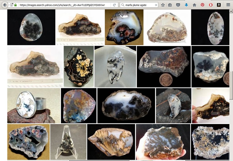
Lets start on the far left with the Marfa Basin. Who isn't fond of the Marfa Plume Agates?

Thank "Solitario" for them! -


Geology
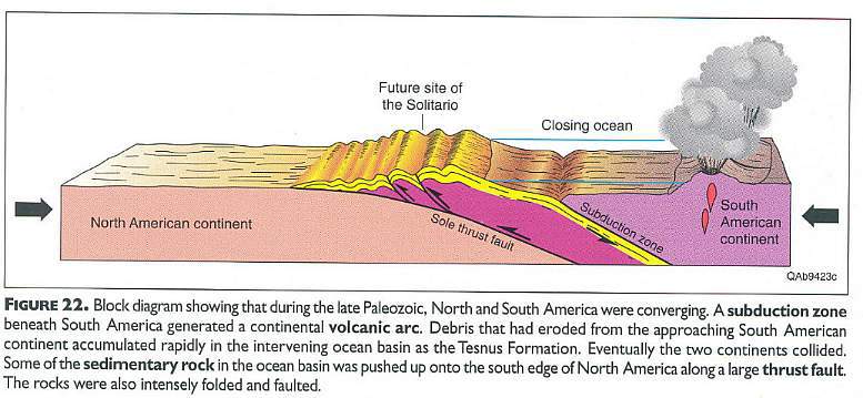
The Solitario is a structural dome developed in Paleozoic and Cretaceous rocks above an Eocene granite laccolith intrusion. The dome is associated with radial rhyolite to trachyte dikes and sills and erupted ash flow tuffs. The 16 km diameter dome contains a 6 by 2 km volcanic cauldera filled with collapse breccia, tuff, and trachyte lava.[2]
The Paleozoic rocks of the dome consist of a 2.6 km thick section of intensely folded Cambrian through Early Pennsylvanian sediments. The Paleozoic rocks were deformed and thrust into the area from the southeast during the Ouachita orogeny. Following the Permian uplift and erosion during most of the Mesozoic was followed by deposition of Cretaceous carbonate rocks which correlate with the Cretaceous of the Gulf Coast. The area was uplifted by the Laramide orogeny during latest Cretaceous. Following the Eocene intrusive and volcanic events of the Solitario, the area was partially covered by volcanic rocks from the adjacent Bofecillos volcanic center to the west of the area during the Oligocene and early Miocene. Erosion and downcutting following the Pleistocene deepening of the Rio Grande to the southwest and south have produced the current topographic expression of the area.[3]
2. Petrified Wood
Above and to the east, in the western Panhandle is the Chinle Petrified Wood - known here as "Docum."

Petrified Palm Wood is the Texas State Rock
statesymbolsusa.org/symbol-official-item/texas/state-dinosaur-fossil-state-rock-mineral/petrified-palmwood
And other Pet wood is found in many parts of the state.
txpetrifiedwood.com/
www.miim.com/thebside/texas99/mville.html
3.Flint
Flint
www.nps.gov/alfl/index.htm
Prized For More Than 13,000 Years
13,000 years ago this site was already well-known by mammoth hunters as a place to get the best stone for their tools. Centuries passed but the colorful flint found right here in the Texas panhandle never lost its value and usefulness. Visit and gain a sense of how integral this site was to the survival, commerce and culture of the High Plains.

paleoplanet69529.yuku.com/topic/28185/where-to-find-flint-in-texas#.WZsVo1GQz9I
status offlineokcman Tejas Rock Locations... #10 [-]
Near the sea shore of Houston - near the jettys you may find some flint - the jettys are often made from large blocks of limestone holding chert and flint nodules -
I have found many pieces of flint that way around Port Aransas Jettys near Corpus Christi - a secondary source is the local sand and gravel places - large nodules and small cobbles can be had for a song -
Near Houston in Baytown , Texas there is Tazz's Enterprises - you can get firewood, slabs of various rock materials like agates pretty inexpensive , and glass(its a rock shop) - don't stare at the Tazz's mohawk or his
wife who is 20 or 25 years his junior. Near College Station I have spent the night and found pieces of petrified wood - but no flint.
you will definitely have to go south and west to start finding anything that is decent to knap...Roundrock and of course Georgetown has a lot of quarries
and sand and gravel places. And JJ is right - I have traded points to a guy near San Antonio near the Alamo for some of the most beautiful cobbles ever....San Antonio has some nice stuff...
I also visited a large rock and gravel place there - spent an afternoon trying to go through a mountain of flint twice the size of my house - 3 buckets of spalls and they laughed at me when I tried to pay-
The KOA near downtown San Antonio has some nice cobbles - I camped out there. I also found some rock at round rock behind the Jack in Box next to I - 35 ....(you can laugh at the last one but it wasn't bad stuff)
4. Texas Topaz
Moving east into the staked Plains, how about some Texas Topaz! -Found weathering out of Pegmatites in Precambrian Rocks from Mason to Burnett


If you are going to search for Texas Topaz, it will help if you know what formations they will be found in.
lonestarjewelry.com/shop/custom.aspx?recid=3
Topaz was first recognized in Mason County in 1904. Old-timers remember stumbling onto the quartzlike gemstone while searching the creek beds for arrowheads. Sometimes the stones were so big, they could be used as doorstops. But it was the arrowhead that had value in those days. The topaz was just another pretty rock.
Mason County boasts the largest gem-quality topaz crystal ever found in North America. It is a 1,296-gram pale blue crystal that now resides in the Smithsonian Institution in Washington. Most pieces are considerably smaller, generally less than a couple of inches long with a diameter of less than an inch.
Texas topaz is usually colorless to white, though some of the most beautiful and startling gemstones are in the light-blue to sky-blue range. In color, size and clarity, Texas topaz is considered among the best in the United States. "Mason County is known for the best-quality stones," Seaquist said. "We have a lot of geology classes from the University of Texas come out here to look for it." But they don't find much.
Yeah, but . . . Where, what, how . . .
The first were found in creek beds like Comanche Creek, next to eroding Packsaddle schist folds that were formed way back when ancient North America slammed into Europe. Packsaddle and the surrounding Valley Spring Gneiss and Town Mountain granite were later intruded by pegmatites where penetrating fluorine gas transformed silicon and aluminum into topaz - a silicate mineral of aluminum and fluorine with the chemical formula Al2SiO4(F,OH)2.
Packsaddle Schist

PS in gold = Packsaddle Schist Locations.

So what does the "packsaddle" look like?
The next two images are from
scholarworks.sfasu.edu/cgi/viewcontent.cgi?article=1001&context=geology


Blue Topaz is the Texas state gemstone as well as the birthstone for the month of November. Blue Topaz is the Texas state gemstone as well as the birthstone for the month of November. It occurs naturally in many colors including blue, orange, brown, green, pink, beige and red. Colorless topaz, a the most common variation, can be treated by irradiation to produce a wide range of shades of blue. Thus treated, blue topaz is one of the most popular and widely used of all gemstones.
Blue topaz was adopted as the state gemstone as the result of legislation approved March 26, 1969. The same legislation also named petrified palm wood as the state stone. It occurs naturally in many colors including blue, orange, brown, green, pink, beige and red. It is especially common in the East Texas Piney Woods region and along the Gulf Coast.
5. Rare Earth Minerals
Buchanan Lake is the site of a famous meteorite impact that provided lots of rare earth minerals. Probably used in making the first transistors.

6 Oil
Oil? - - - in Texas?


